Hayle Estuary
Coordinates: 50°11′31″N 5°26′06″W / 50.192°N 5.435°W
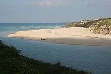
The Hayle Estuary (Cornish: Heyl, meaning estuary) is an estuary in west Cornwall, England, United Kingdom.
The estuary of the River Hayle consists of a main channel, with several other nearby tidal areas, including Lelant Saltings, Copperhouse Creek (Cornish: Est Logh, meaning eastern inlet) and Carnsew Pool (also known as Carnsew Basin).
It is included in the Hayle Estuary and Carrack Gladden Site of Special Scientific Interest.
The Royal Society for the Protection of Birds manages a nature reserve at the site.
History
In 1825 an Act of Parliament established the Hayle Bridge Causeway Turnpike Trust which was required to construct a bridge, causeway and turnpike over the Hayle River from Griggs Quay (grid reference SW545363) in the west to Phillack in the east. The turnpike was needed to ease the transport of copper ore to the port at Hayle for export. A second Act was passed in 1837 to establish the Griggs Quay to Penzance Turnpike and in 1839 an Act formed the a third trust, the Hayle and Redruth Turnpike to complete the turnpike to Redruth.[1] The running of the turnpike was overseen by the winner of a public auction. For the year 1880, the winning bid was £591 10s.[2]
See also
References
- ↑ Historic England & 1405965
- ↑ Cornish, Thomas (23 September 1880). "Hayle Bridge Causeway and Turnpike Road". The Cornishman (115). p. 1.
External links
| Wikimedia Commons has media related to Hayle Estuary. |
Cornwall Portal | |
| Unitary authorities | |
| Major settlements |
|
| Rivers | |
| Topics | |