Hayes Range
| Hayes Range | |
|---|---|
 | |
| Highest point | |
| Peak | Mount Hayes |
| Elevation | 13,832 ft (4,216 m) |
| Coordinates | 63°33′00″N 147°53′00″W / 63.55000°N 147.88333°WCoordinates: 63°33′00″N 147°53′00″W / 63.55000°N 147.88333°W |
| Dimensions | |
| Length | 147 mi (237 km) |
| Area | 13,406 sq mi (34,720 km2) |
| Geography | |
 Hayes Range Location in Alaska | |
| Country | United States |
| State/Province | Alaska |
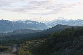
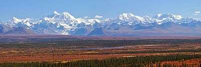
The Hayes Range is a part of the Alaska Range in Denali and Southeast Fairbanks, Alaska in the United States. The mountains are located to the east of Denali National Park and are located west of the Delta Mountains, from which they are separated by the Delta River. As the crow flies, the Hayes Range is located about 150 miles (240 km) south of Fairbanks, and 200 miles (320 km) northeast of Anchorage. The mountains extend about 147 miles (237 km) from east to west.[1]
The highest point of the range is Mount Hayes, 13,832 feet (4,216 m).[1]
References
- 1 2 "Hayes Range". Peakbagger. 2004. Retrieved 2016-12-26.
This article is issued from
Wikipedia.
The text is licensed under Creative Commons - Attribution - Sharealike.
Additional terms may apply for the media files.