Alaska Range
| Alaska Range | |
|---|---|
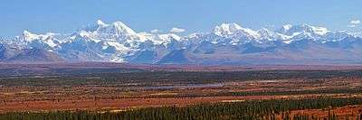
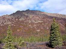
.jpg) Mount Hunt, Mount Huntington and other rugged peaks of the Alaska Range near Denali | |
| Highest point | |
| Peak | Denali |
| Elevation | 6,200.5 m (20,343 ft) |
| Coordinates | 63°04′10″N 151°00′26″W / 63.06944°N 151.00722°WCoordinates: 63°04′10″N 151°00′26″W / 63.06944°N 151.00722°W |
| Geography | |
 | |
| Country | United States |
| State | Alaska |
| Borders on | Pacific Coast Ranges |
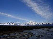
The Alaska Range is a relatively narrow, 650-km-long (400 mi) mountain range in the southcentral region of the U.S. state of Alaska, from Lake Clark at its southwest end[1] to the White River in Canada's Yukon Territory in the southeast. The highest mountain in North America, Denali, is in the Alaska Range. It is part of the American Cordillera.
The range is the highest in the world outside Asia and the Andes.
Description and history
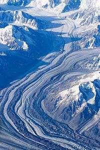
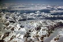
The range forms a generally east-west arc with its northernmost part in the center, and from there trending southwest towards the Alaska Peninsula and the Aleutians, and trending southeast into the Pacific Coast Ranges. The mountains act as a high barrier to the flow of moist air from the Gulf of Alaska northwards, and thus has some of the harshest weather in the world. The heavy snowfall also contributes to a number of large glaciers, including the Canwell, Castner, Black Rapids, Susitna, Yanert, Muldrow, Eldridge, Ruth, Tokositna, and Kahiltna Glaciers. Four major rivers cross the Range, including the Delta River, and Nenana River in the center of the range and the Nabesna and Chisana Rivers to the east.
The range is part of the Pacific Ring of Fire, and the Denali Fault that runs along the southern edge of the range is responsible for a number of earthquakes. Mount Spurr is a stratovolcano located in the northeastern end of the Aleutian Volcanic Arc of Alaska, USA which has two vents, the summit and nearby Crater Peak.
Parts of the range are protected within Wrangell-St. Elias National Park and Preserve, Denali National Park and Preserve, and Lake Clark National Park and Preserve. The George Parks Highway from Anchorage to Fairbanks, the Richardson Highway from Valdez to Fairbanks, and the Tok Cut-Off from Gulkana Junction to Tok, Alaska pass through low parts of the range. The Alaska Pipeline parallels the Richardson Highway.
Naming history
The name "Alaskan Range" appears to have been first applied to these mountains in 1869 by naturalist W. H. Dall. The name eventually became "Alaska Range" through local use. In 1849 Constantin Grewingk applied the name "Tschigmit" to this mountain range. A map made by the General Land Office in 1869 calls the southwestern part of the Alaska Range the "Chigmit Mountains" and the northeastern part the "Beaver Mountains".[2] However the Chigmit Mountains are now considered part of the Aleutian Range.
Major peaks
- Denali (6,190.5 m/20,310 ft)
- Mount Foraker (5,304 m/17,400 ft)
- Mount Hunter (4,442 m/14,573 ft)
- Mount Hayes (4,216 m/13,832 ft)
- Mount Silverthrone (4,029 m/13,218 ft)
- Mount Moffit (3,970 m/13,020 ft)
- Mount Deborah (3,761 m/12,339 ft)
- Mount Huntington (3,730 m/12,240 ft)
- Mount Brooks (3,624 m/11,890 ft)
- Mount Russell (3,557 m/11,670 ft)
Subranges (from west to east)
- Neacola Mountains[1]
- Revelation Mountains
- Teocalli Mountains
- Kichatna Mountains
- Central Alaska Range/Denali Massif
- Eastern Alaska Range/Hayes Range
- Delta Mountains
- Mentasta Mountains
- Nutzotin Mountains
Documented wilderness traverses of Alaska Range
- Mentasta Lake to Kitchatna Mountains (1981): Scott Woolums, George Beilstein, Steve Eck, and Larry Coxen by skis: first traverse. 375 miles (604 km) in 45 days.[3]
- Canada to Lake Clark (1996): Roman Dial, Carl Tobin, and Paul Adkins by mountain bike and packraft: first full length traverse. 775 miles (1,247 km) in 42 days.[4]
- Tok to Lake Clark (1996): Kevin Armstrong, Doug Woody, and Jeff Ottmers by snowshoe, foot, and packraft: first foot traverse. 620 miles (1,000 km) in 90 days.[5]
- Lake Clark to Mentasta Lake (2016): Gavin McClurg by paraglider and foot: first vol-biv (fly/camp) traverse. 466 miles (750 km) in 37 days.[6]
See also
References
- 1 2 Sources differ as to the exact delineation of the Alaska Range. The Board on Geographic Names entry is inconsistent; part of it designates Iliamna Lake as the southwestern end, and part of the entry has the range ending at the Telaquana and Neacola Rivers. Other sources identify Lake Clark, in between those two, as the endpoint. This also means that the status of the Neacola Mountains is unclear: it is usually identified as the northernmost subrange of the Aleutian Range, but it could also be considered the southernmost part of the Alaska Range.
- ↑ Name history from the Board on Geographic Names entry for the Alaska Range.
- ↑ American Alpine Journal (1982), Vol. 24. Pages 137-138
- ↑ "A Wild Ride," National Geographic Magazine (1997), Vol. 191. Pages 118-131
- ↑ American Alpine Journal (1997), Vol. 39. Pages 169-170
- ↑ Cross Country Magazine, Vol 171. Pages 52-52. Red Bull Media House Films "Under the Midnight Sun"
Further reading
| Wikimedia Commons has media related to Alaska Range. |
- Churkin, M., Jr., and C. Carter. (1996). Stratigraphy, structure, and graptolites of an Ordovician and Silurian sequence in the Terra Cotta Mountains, Alaska Range, Alaska [U.S. Geological Survey Professional Paper 1555]. Washington, D.C.: U.S. Department of the Interior, U.S. Geological Survey.
| Authority control |
|---|