Haug Range
| Haug Range | |
|---|---|
| Hauge Bjerge | |
 Location | |
| Highest point | |
| Peak | Kayser Mountain |
| Elevation | 1,094 m (3,589 ft) |
| Dimensions | |
| Length | 60 km (37 mi) E/W |
| Width | 10 km (6.2 mi) N/S |
| Geography | |
| Country | Greenland |
| Range coordinates | 81°30′N 59°35′W / 81.500°N 59.583°WCoordinates: 81°30′N 59°35′W / 81.500°N 59.583°W |
| Geology | |
| Age of rock | Lower Silurian |
The Haug Range (Danish: Hauge Bjerge)[1] is a mountain range in far northeastern Greenland. Administratively this range is part of the Qaasuitsup municipality. The range is located in Hall Land, one of the coldest places in Greenland.[2]
This mountain chain was named after Ivar Haug, who compiled the first Gazetteer of Greenland. The area of the range is characterized by Tundra climate.[3]
Geography
The Haug Range is an up to almost 1,100 m high little glaciated mountain range in Hall Land. It runs roughly from east to west across the peninsula, from the shores of the Nares Strait to the shores of the Newman Bay, separating the unglaciated Polaris Foreland in the north from the southern part of Hall Land.[4] 1,094 metres (3,589 ft) high Kayser Mountain, the highest elevation of the range, is located at its northeastern end.[5] The area of the Haug Rage is uninhabited.[5]
Pentamerus fossils dating back to the Lower Silurian have been found in this mountain range.[6] They belong to the Hauge Bjerge Formation.[7]
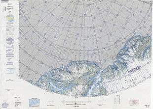 Map of the Nares Strait area. |
See also
Bibliography
References
- ↑ "Hauge Bjerge". Mapcarta. Retrieved 15 July 2016.
- ↑ Hall Land (Grønland)
- ↑ "Peel, M C; Finlayson, B L; McMahon, T A (2007). Updated world map of the Köppen-Geiger climate classification". Hydrology and Earth System Sciences 11: sid. 1633-1644. doi:10.5194/hess-11-1633-2007. Retrieved 15 July 2016.
- ↑ "Hall Land". Mapcarta. Retrieved 15 July 2016.
- 1 2 Google Earth
- ↑ Jin, Jisuo (2009). "SULCIPENTAMERUS(PENTAMERIDA, BRACHIOPODA) FROM THE LOWER SILURIAN WASHINGTON LAND GROUP, NORTH GREENLAND". Palaeontology. 52: 385–399. doi:10.1111/j.1475-4983.2009.00849.x.
- ↑ Hauge Bjerge Formation - Peary Land Group
External links