Hall Land
 Hall Land | |
| Geography | |
|---|---|
| Location | NW Greenland |
| Coordinates | 81°20′N 58°0′W / 81.333°N 58.000°WCoordinates: 81°20′N 58°0′W / 81.333°N 58.000°W |
| Adjacent bodies of water |
Hall Basin Newman Bay |
| Length | 150 km (93 mi) |
| Width | 70 km (43 mi) |
| Highest elevation | 1,094 m (3,589 ft) |
| Highest point | Kayser Mountain |
| Administration | |
|
Greenland (Denmark) | |
| Municipality | Qaasuitsup |
Hall Land is a peninsula in far northwestern Greenland. It is a part of the Qaasuitsup municipality. Hall Land is one of the coldest places in Greenland.[1]
The last live caribou reported from Northern Greenland were seen in Hall Land in 1922. They were most likely Peary caribou that had strayed across the channel from Ellesmere Island.[2]
Geography
Hall Land is located to the northeast of Daugaard-Jensen Land and the southwest of Nyeboe Land. It is surrounded to the north by the Robeson Channel of the Nares Strait and to the east by the Newman Bay. Hall Basin, the Petermann Fjord and the Petermann Glacier mark the western limits of Hall Land. To the south and southeast the peninsula is attached to the mainland and its ice cap.
The unglaciated Polaris Foreland lies in the northernmost part of Hall Land beyond the Haug Range.[3] 1,094 metres (3,589 ft) high Kayser Mountain, the highest elevation of the peninsula, is located at the northeastern end of the range.[4]
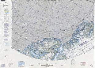 Map of the Nares Strait area. |
See also
References
- ↑ Hall Land (Grønland)
- ↑ Morten Meldgaard, (1986) The Greenland Caribou - Zoogeography, Taxonomy, and Population Dynamics, ISBN 978-87-635-1180-3 p. 44
- ↑ "Hall Land". Mapcarta. Retrieved 10 April 2016.
- ↑ GoogleEarth