Hatfield, Pretoria
| Hatfield | |
|---|---|
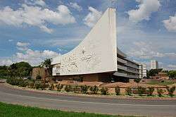 University of Pretoria's Administration building ("Die skip") on its Hatfield campus | |
 Hatfield  Hatfield Hatfield (South Africa)  Hatfield Hatfield (Africa) | |
| Coordinates: 25°44′53″S 28°14′17″E / 25.748°S 28.238°ECoordinates: 25°44′53″S 28°14′17″E / 25.748°S 28.238°E | |
| Country | South Africa |
| Province | Gauteng |
| Municipality | City of Tshwane |
| Main Place | Pretoria |
| Area[1] | |
| • Total | 1.97 km2 (0.76 sq mi) |
| Population (2011)[1] | |
| • Total | 9,274 |
| • Density | 4,700/km2 (12,000/sq mi) |
| Racial makeup (2011)[1] | |
| • Black African | 50.8% |
| • Coloured | 2.5% |
| • Indian/Asian | 5.3% |
| • White | 43.9% |
| • Other | 1.4% |
| First languages (2011)[1] | |
| • English | 33.1% |
| • Afrikaans | 28.9% |
| • Tswana | 7.0% |
| • Zulu | 6.0% |
| • Other | 25.0% |
| Time zone | UTC+2 (SAST) |
| Postal code (street) | 0002 |
| PO box | 0028 |
| Area code | 012 |
Hatfield is a suburb in Pretoria, South Africa with a high density of students and student accommodation due its proximity to the University of Pretoria's main campus.
Hatfield is home for one of the major campuses of University of Pretoria. Hatfield also houses one of the main stations for the Gautrain, South Africa's premiere mass rapid transit railway.
References
- 1 2 3 4 "Sub Place Hatfield". Census 2011.
.svg.png)
This article is issued from
Wikipedia.
The text is licensed under Creative Commons - Attribution - Sharealike.
Additional terms may apply for the media files.