Bronkhorstspruit
| Bronkhorstspruit | |
|---|---|
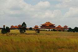 The Nan Hua Temple Complex in Bronkhorstspruit | |
 Bronkhorstspruit  Bronkhorstspruit Bronkhorstspruit (South Africa)  Bronkhorstspruit Bronkhorstspruit (Africa) | |
| Coordinates: 25°48′18″S 28°44′47″E / 25.80500°S 28.74639°ECoordinates: 25°48′18″S 28°44′47″E / 25.80500°S 28.74639°E | |
| Country | South Africa |
| Province | Gauteng |
| Municipality | City of Tshwane |
| Established | 1905 |
| Area[1] | |
| • Total | 3.11 km2 (1.20 sq mi) |
| Elevation | 1,375 m (4,511 ft) |
| Population (2011)[1] | |
| • Total | 3,720 |
| • Density | 1,200/km2 (3,100/sq mi) |
| Time zone | UTC+2 (SAST) |
| Postal code (street) | 1020 |
| PO box | 1020 |
| Area code | 013 |
Bronkhorstspruit is a town 50 km east of Pretoria, Gauteng, South Africa along the N4 highway towards Witbank. It lies on the border between the Gauteng and Mpumalanga provinces. It also consists of three townships called Zithobeni, Rethabiseng and Ekangala.
On 18 May 2011 Tshwane Metropolitan Municipality took over the municipal administration from the abolished Kungwini Local Municipality.
History
In 1858, a group of Voortrekkers settled in the Bronkhorstspruit creek, which was originally called Kalkoenkransrivier ('Turkey Cliff River'). The town was laid out on land of the farm Hondsrivier owned C.J.G. Erasmus and was initially named after him.[2] It adopted the name Bronkhorstspruit in 1935.[3]:296
On 20 December 1880 it was the scene of the action at Bronkhorstspruit, an important event in the early days of the First Boer War when a Boer Commando ambushed a British army column, 94th Regiment of Foot, near the present town en route from Lydenburg to Pretoria.[3]:296
There is disagreement about where the town got its name from. Some believe it was named after the farmer JG Bronkhorst, while others say that it was named after the plant, bronkors (Afrikaans for watercress), that grew in the region of the creek.[3]:296
Parks and greenspace
Ten kilometers to the south of the town lies the Bronkhorstspruit Dam.[3]:296
Economy
Agriculture
Being an agricultural area, maize, sorghum, groundnuts, sunflower seeds, sheep and cattle are grown and raised.[3]:296
Mining
Places of interest
Cultura Park, a suburb of Bronkhorstspruit, hosts the largest Buddhist temple in the Southern Hemisphere. Nan Hua Temple houses the South African theadquarters of the Humanistic Buddhist order.
References
External links
.svg.png)