Handenberg
| Handenberg | ||
|---|---|---|
| ||
 Handenberg Location within Austria | ||
| Coordinates: 48°08′00″N 13°00′30″E / 48.13333°N 13.00833°ECoordinates: 48°08′00″N 13°00′30″E / 48.13333°N 13.00833°E | ||
| Country | Austria | |
| State | Upper Austria | |
| District | Braunau am Inn | |
| Government | ||
| • Mayor | Gottfried Neumaier (ÖVP) | |
| Area | ||
| • Total | 27.59 km2 (10.65 sq mi) | |
| Elevation | 497 m (1,631 ft) | |
| Population (14 June 2016)[1] | ||
| • Total | 1,288 | |
| • Density | 47/km2 (120/sq mi) | |
| Time zone | UTC+1 (CET) | |
| • Summer (DST) | UTC+2 (CEST) | |
| Postal code | 5144 | |
| Area code | 07748 | |
| Vehicle registration | BR | |
| Website | www.handenberg.ooe.gv.at | |
Handenberg is an Austrian municipality in the district of Braunau am Inn in the Austrian state of Upper Austria.
Geography
The Fillmannsbach flows through the municipality from south to north.
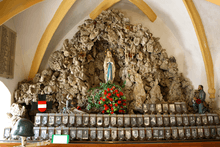
Lourdes Grotto in Handenberg
References
| Wikimedia Commons has media related to Handenberg. |
This article is issued from
Wikipedia.
The text is licensed under Creative Commons - Attribution - Sharealike.
Additional terms may apply for the media files.