Geretsberg
| Geretsberg | ||
|---|---|---|
 | ||
| ||
 Geretsberg Location within Austria | ||
| Coordinates: 48°05′20″N 12°56′05″E / 48.08889°N 12.93472°ECoordinates: 48°05′20″N 12°56′05″E / 48.08889°N 12.93472°E | ||
| Country | Austria | |
| State | Upper Austria | |
| District | Braunau am Inn | |
| Government | ||
| • Mayor | Josef Lechner (ÖVP) | |
| Area | ||
| • Total | 37.43 km2 (14.45 sq mi) | |
| Elevation | 491 m (1,611 ft) | |
| Population (14 June 2016)[1] | ||
| • Total | 1,126 | |
| • Density | 30/km2 (78/sq mi) | |
| Time zone | UTC+1 (CET) | |
| • Summer (DST) | UTC+2 (CEST) | |
| Postal codes | 5121, 5131, 5132, 5133 | |
| Area code | 07748 | |
| Vehicle registration | BR | |
| Website | ||
Geretsberg is a municipality in the district Braunau am Inn in the Austrian state of Upper Austria.
Geography
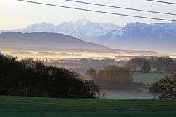
Geretsberg lies in the Innviertel. About 69 percent of the municipality is forest and 27 percent farmland.
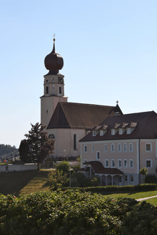
Church in Geretsberg
References
| Wikimedia Commons has media related to Geretsberg. |
This article is issued from
Wikipedia.
The text is licensed under Creative Commons - Attribution - Sharealike.
Additional terms may apply for the media files.