Hampstead, Maryland
| Hampstead, Maryland | ||
|---|---|---|
| Town | ||
_at_Maryland_State_Route_833_(Black_Rock_Road)_in_Hampstead%2C_Carroll_County%2C_Maryland.jpg) Northbound on Main Street in Hampstead | ||
| ||
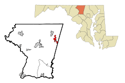 Location of Hampstead, Maryland | ||
| Coordinates: 39°36′37″N 76°51′5″W / 39.61028°N 76.85139°WCoordinates: 39°36′37″N 76°51′5″W / 39.61028°N 76.85139°W | ||
| Country | United States | |
| State | Maryland | |
| County | Carroll | |
| Incorporated | 1888[1] | |
| Area[2] | ||
| • Total | 3.21 sq mi (8.31 km2) | |
| • Land | 3.19 sq mi (8.26 km2) | |
| • Water | 0.02 sq mi (0.05 km2) | |
| Elevation | 928 ft (283 m) | |
| Population (2010)[3] | ||
| • Total | 6,323 | |
| • Estimate (2016)[4] | 6,355 | |
| • Density | 2,000/sq mi (760/km2) | |
| Time zone | UTC-5 (Eastern (EST)) | |
| • Summer (DST) | UTC-4 (EDT) | |
| ZIP code | 21074 | |
| Area code(s) | 410,443 | |
| FIPS code | 24-36500 | |
| GNIS feature ID | 0590408 | |
| Website |
www | |
Hampstead is a town in Carroll County in the U.S. state of Maryland. The population was 6,323 at the 2010 census.[5]
History
Between 1736 and 1738, Robert Owings was assigned to "cut a new road as Christopher Gist had marked it" south from Conewago (now Hanover, Pennsylvania) to a point about halfway to Fort Garrison in Baltimore County. The village of Spring Garden became a stage-line stop on the new road and later became the town of Hampstead, named after Hampstead, in England.[6] The first settlers to the area were English immigrants who made their way west from the Port of Philadelphia. They were followed by Scots and Germans. Hampstead was used by farmers from surrounding areas as a center to obtain goods brought from Baltimore and to send produce to markets in Baltimore and Pennsylvania. The level and fertile land, coupled with the availability of lime, gave farmers important advantages for successful farming. In 1879, the Harrisburg Division of the Western Maryland Railroad reached Hampstead. The accessibility of the railroad attracted new residents and made dairy farming profitable.
Hampstead has developed from a farming community to a modern town of about 6,300 residents. Community activities center around the town’s numerous organizations and its schools - Hampstead Day, the Christmas Village, and school sporting events, for examples.
Hampstead’s Town Office was once located in a side room of the old First National Bank building on Main Street. (This building is now the Police Department’s station.) During the Depression the bank closed and was later purchased by Mayor Les Wheeler, who in 1950 rented it to the Town. In the late 1960s the Town Office moved to the basement of Hampstead Baptist Church on S. Carroll Street. In 1980 the church moved into a larger structure along Route 30 and Town Office, along with the Police Department, was able to utilize the entire building on S. Carroll Street. In 2000 the Police Department moved into the old First National Bank building, now fully restored - bringing the Town full circle. Although the Mayor and Council had the authority since 1888 to appoint constables, it wasn’t until the 1950s that James Boone became the Town’s first official police officer.
Incorporated in 1888, the Town of Hampstead celebrated its 125th Anniversary in 2013.
Hampstead School was listed on the National Register of Historic Places in 2002.[7] (This school had been empty and derelict before the Town facilitated a transfer of the property from Carroll County Government to Landex Inc. Landex then rehabilitated the building into a retirement living community known as The Residences at Hampstead School.)
Geography
Hampstead is located at 39°36′37″N 76°51′5″W / 39.61028°N 76.85139°W (39.610303, -76.851493).[8] According to the United States Census Bureau, the town has a total area of 3.21 square miles (8.31 km2), of which, 3.19 square miles (8.26 km2) is land and 0.02 square miles (0.05 km2) is water.[2]
Hampstead is approximately 3 miles (5 km) south of Manchester, 6 miles (10 km) east of Westminster, and 9 miles (14 km) north of Reisterstown.
Demographics
| Historical population | |||
|---|---|---|---|
| Census | Pop. | %± | |
| 1860 | 198 | — | |
| 1870 | 235 | 18.7% | |
| 1880 | 306 | 30.2% | |
| 1890 | 521 | 70.3% | |
| 1900 | 480 | −7.9% | |
| 1910 | 555 | 15.6% | |
| 1920 | 566 | 2.0% | |
| 1930 | 905 | 59.9% | |
| 1940 | 664 | −26.6% | |
| 1950 | 677 | 2.0% | |
| 1960 | 696 | 2.8% | |
| 1970 | 961 | 38.1% | |
| 1980 | 1,293 | 34.5% | |
| 1990 | 2,608 | 101.7% | |
| 2000 | 5,060 | 94.0% | |
| 2010 | 6,323 | 25.0% | |
| Est. 2016 | 6,355 | [4] | 0.5% |
| U.S. Decennial Census[9] | |||
2010 census
As of the census[3] of 2010, there were 6,323 people, 2,415 households, and 1,658 families residing in the town. The population density was 1,982.1 inhabitants per square mile (765.3/km2). There were 2,500 housing units at an average density of 783.7 per square mile (302.6/km2). The racial makeup of the town was 94.0% White, 2.0% African American, 0.3% Native American, 1.4% Asian, 0.9% from other races, and 1.5% from two or more races. Hispanic or Latino of any race were 3.0% of the population.
There were 2,415 households of which 42.5% had children under the age of 18 living with them, 52.8% were married couples living together, 11.4% had a female householder with no husband present, 4.5% had a male householder with no wife present, and 31.3% were non-families. 26.7% of all households were made up of individuals and 11.1% had someone living alone who was 65 years of age or older. The average household size was 2.62 and the average family size was 3.20.
The median age in the town was 35.2 years. 28.4% of residents were under the age of 18; 7.7% were between the ages of 18 and 24; 30.1% were from 25 to 44; 23.9% were from 45 to 64; and 9.8% were 65 years of age or older. The gender makeup of the town was 47.3% male and 52.7% female.
2000 census
As of the census[10] of 2000, there were 5,060 people, 1,787 households, and 1,327 families residing in the town. The population density was 1,887.1 people per square mile (729.0/km²). There were 1,851 housing units at an average density of 690.3 per square mile (266.7/km²). The racial makeup of the town was 97.79% White, 0.79% African American, 0.06% Native American, 0.51% Asian, 0.06% from other races, and 0.79% from two or more races. Hispanic or Latino of any race were 1.09% of the population.
There were 1,787 households out of which 50.7% had children under the age of 18 living with them, 59.3% were married couples living together, 11.4% had a female householder with no husband present, and 25.7% were non-families. 21.6% of all households were made up of individuals and 6.7% had someone living alone who was 65 years of age or older. The average household size was 2.83 and the average family size was 3.32.
In the town, the population was spread out with 34.7% under the age of 18, 5.8% from 18 to 24, 39.5% from 25 to 44, 14.2% from 45 to 64, and 5.8% who were 65 years of age or older. The median age was 31 years. For every 100 females, there were 94.3 males. For every 100 females age 18 and over, there were 88.0 males.
The median income for a household in the town was $56,655, and the median income for a family was $62,460. Males had a median income of $45,000 versus $30,407 for females. The per capita income for the town was $22,730. About 1.3% of families and 2.4% of the population were below the poverty line, including 1.5% of those under age 18 and 6.4% of those age 65 or over.
Education
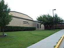
The main schools In Hampstead are North Carroll Middle School, Shiloh Middle School, Spring Garden Elementary School and Hampstead Elementary School, which also service other towns and unincorporated areas nearby.
Awards
In 2012 Hampstead was named "Best Place To Raise Children in Maryland" by Bloomberg Businessweek and "Safest Place to Live in Maryland" by Movoto.
In 2014 the Hampstead Farmers' Market was presented with the first "Carroll County Downtown Community Builder Award" by Carroll County Economic Development.
In 2016 Hampstead was ranked the Fourth Most Affordable Town in Maryland in which to live.
Zippia listed Hampstead as the 2nd Best City in Maryland to Achieve Work-Life Balance.
Business
There are many successful businesses in Hampstead, especially on its Main Street corridor.
- FUCHS North America, the U.S. subsidiary of the world's largest privately-owned spice and food seasoning company, has its corporate headquarters and state-of-the-art manufacturing facility on a 20+ acre campus just off Hampstead's Main Street. The company is a recognized industry leader which sells industrial seasoning blends and spices across the U.S., Europe, and the world, with unique strengths in the snack food seasoning industry.
- The headquarters of JoS. A. Bank Clothiers is located in Hampstead.
Notable people
Katie Zaferes, triathlete Thomas 'Tommy B' Bowman, Skateboarder, Co-Star season 3 of Fuel TV's "Camp Woodward", host of TommyPalooza
References
- ↑ "Hampstead". Maryland Manual. Retrieved 25 June 2017.
- 1 2 "US Gazetteer files 2010". United States Census Bureau. Retrieved 2013-01-25.
- 1 2 "American FactFinder". United States Census Bureau. Retrieved 2013-01-25.
- 1 2 "Population and Housing Unit Estimates". Retrieved June 9, 2017.
- ↑ "Profile of General Population and Housing Characteristics: 2010 Demographic Profile Data (DP-1): Hampstead town, Maryland". U.S. Census Bureau, American Factfinder. Retrieved August 6, 2012.
- ↑ Gannett, Henry (1905). The Origin of Certain Place Names in the United States. Govt. Print. Off. p. 148.
- ↑ National Park Service (2008-04-15). "National Register Information System". National Register of Historic Places. National Park Service.
- ↑ "US Gazetteer files: 2010, 2000, and 1990". United States Census Bureau. 2011-02-12. Retrieved 2011-04-23.
- ↑ "Census of Population and Housing". Census.gov. Retrieved June 4, 2015.
- ↑ "American FactFinder". United States Census Bureau. Retrieved 2008-01-31.
External links
| Wikimedia Commons has media related to Hampstead, Maryland. |
Municipalities and communities of Carroll County, Maryland, United States | ||
|---|---|---|
| Cities | 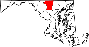 | |
| Towns | ||
| CDP | ||
| Other communities |
| |
| Footnotes | ‡This populated place also has portions in an adjacent county | |