Detour, Maryland
| Detour, Maryland | |
|---|---|
| Unincorporated community | |
_between_Keysville_Road_and_Circle_Drive_in_Detour%2C_Carroll_County%2C_Maryland.jpg) View east along MD 77 in Detour | |
 Detour Location within the state of Maryland  Detour Detour (the US) | |
| Coordinates: 39°36′14″N 77°16′05″W / 39.60389°N 77.26806°WCoordinates: 39°36′14″N 77°16′05″W / 39.60389°N 77.26806°W | |
| Country | United States |
| State | Maryland |
| County | Caroll |
| Time zone | UTC-5 (Eastern (EST)) |
| • Summer (DST) | UTC-4 (EDT) |
Detour is an unincorporated community in Carroll County, Maryland, United States.[1]
History
A post office called Detour was established in 1905, and remained in operation until 1993.[2] According to tradition, the indirect route of the railroad extending to the site accounts for the name.[3]
William and Catherine Biggs Farm was listed on the National Register of Historic Places in 2001.[4]
References
- ↑ "Geographic Names Information System". Detour (Populated Place). U.S. Geological Survey. 2009-01-29.
- ↑ "Post Offices". Jim Forte Postal History. Retrieved 5 January 2017.
- ↑ Moyer, Armond; Moyer, Winifred (1958). The origins of unusual place-names. Keystone Pub. Associates. p. 33.
- ↑ National Park Service (2008-04-15). "National Register Information System". National Register of Historic Places. National Park Service.
Municipalities and communities of Carroll County, Maryland, United States | ||
|---|---|---|
| Cities | 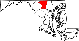 | |
| Towns | ||
| CDP | ||
| Other communities |
| |
| Footnotes | ‡This populated place also has portions in an adjacent county | |
This article is issued from
Wikipedia.
The text is licensed under Creative Commons - Attribution - Sharealike.
Additional terms may apply for the media files.