Hall Island (Arctic)
| Russian: Остров Галля | |
|---|---|
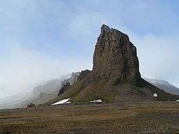 View of Cape Tegethoff | |
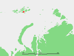 Location of Hall Island in the Franz Josef Archipelago | |
| Geography | |
| Location | Arctic |
| Coordinates | 80°05′N 58°01′E / 80.083°N 58.017°E |
| Archipelago | Franz Josef Archipelago |
| Area | 1,049 km2 (405 sq mi) |
| Highest elevation | 502 m (1,647 ft) |
| Highest point | Kupol Moskvy |
| Administration | |
Hall Island (Russian: Остров Галля; Ostrov Gallya) is an island in Franz Josef Land, Arkhangelsk Oblast, Russia.
History
This island was discovered on August 30, 1873, by the Austro-Hungarian North Pole Expedition. It was the first major island of the Franz Josef group on which the expedition members set foot.
In 1898-99 a small camp was built at Mys Tegetkhof (Cape Tegethoff, 80°05′N 58°01′E / 80.083°N 58.017°E) by the Walter Wellman expedition. It contains a marker commemorating the discovery of the archipelago. Cape Tegethoff was named after the main ship of the Austro-Hungarian explorers, which had been named in honor of Austrian admiral Wilhelm von Tegetthoff.[1][2]
Geography
Hall Island is almost completely covered by glaciers. Its highest point is 502 m (1,647 ft) and it is the summit of the Kupol Moskvy (Купол Москвы) ice dome that covers the central part of the island. Besides the ice dome there is a glacier with its terminus in the southern shore, the Sonklar Glacier.[3]
The only relatively large areas free of permanent ice are located in its southern end, where there are two headlands, Cape Tegethoff (Mys Tegetkhoff), and also Cape Ozernyy (Mys Ozernyy), on Littrov Peninsula, (Poluostrov Littrova). There is also a very small unglacierized area around its eastern cape, Mys Frankfurt, and another in its northwestern point, Cape Wiggins (Mys Uigginsa).
Hall Island's area is 1,049 km2 (405 sq mi) and it is one of the largest islands in the group. There is a wide bay on the southeastern side of Hall Island known as Hydrographer Bay (Zaliv Gidrografov) and a smaller one west of the Littrov Peninsula called Bukhta Surovaya.
Hall Island is located very close to the eastern shores of MacKlintok Island, separated from it by a narrow sound. To the southeast there is a wider strait separating Hall Island from Salm Island known in Russian as Proliv Lavrova. The strait to the east is the large Avstriskiy Proliv.
Hall Island was named after American Arctic explorer Charles Francis Hall.
Adjacent minor islands
- Right off Hall Island's northern shore lie three small islets called Brown Islands (Ostrova Brounova). They were named in honor of George Brown, of the Royal Navy, who went in the 1850-1854 expedition in search of Sir John Franklin, under the command of Captain R. M'Clure, on the Investigator.
- 6 km (3.7 mi) west of Hall island's northwestern cape lies oval-shaped 5 km (3.1 mi) long Newcomb Island (Остров Нюкомба, Ostrov N'yukomba). Unglacierized. Highest point 67 m (220 ft). This island was named after Raymond Lee Newcomb, the naval officer in charge of the 1882–84 party searching for the ill-fated DeLong's expedition on ship Jeannette.
- 1.5 km (0.93 mi) off the northeastern side of Hall Island's eastern bay lies small but steep Berghaus Island (Остров Бергхауз, Ostrov Bergkhauz), reaching a height of 372 m (1,220 ft). Unglacierized. This island was named after cartographer Heinrich Berghaus (1797-1884).
See also
References
- ↑ Travellers and Explorers, 1846–1900. § 35. Arctic Exploration.
- ↑ Franklin Expedition and Arctic Exploration collection
- ↑ "Kupol Moskvy". Mapcarta. Retrieved 6 October 2016.
External links
- populargeograf.ru
- GEO - (in Russian)
- List of islands and islets (in Russian): ru:Список островов России