Halifax Street, Adelaide
| Halifax Street South Australia | |
|---|---|
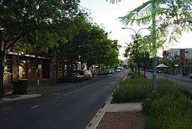 | |
| View of Halifax Street facing east between King William and Pulteney streets | |
| Adelaide | |
| General information | |
| Type | Street |
| Location | Adelaide |
| Length | 1.5 km (0.9 mi)[1] |
| Major junctions | |
| west end | King William Street |
| east end | East Terrace |
Halifax Street is a street in the south-eastern sector of the centre of Adelaide, South Australia.[2][3] It runs east–west between East Terrace and King William Street, crossing Hutt Street and Pulteney Street and passing through Hurtle Square.[2][3] It was named after Sir Charles Wood (later Charles Wood, 1st Viscount Halifax), British Member of Parliament for Halifax.[4]
Halifax Street is one of the intermediate-width streets of the Adelaide grid, at 1 1⁄2 chains (99 ft; 30 m) wide.
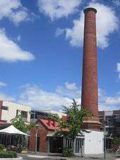
Circa 1844 Halifax Street became the location of one of Adelaide's first breweries, founded by William Henry Clark[6] who later built a flour mill close by. The brewery and mill were sited on city acres 564 and 603 between Halifax and Gilles streets which, from 1909 to 1950, housed Adelaide's rubbish incinerator.[7]
Junction list
| Location | km[1] | mi | Destinations | Notes | |
|---|---|---|---|---|---|
| Adelaide city centre | 0 | 0.0 | King William Street | Continues as Sturt Street | |
| 0.55 | 0.34 | Pulteney Street | In Hurtle Square | ||
| 1.1 | 0.68 | Hutt Street | |||
| 1.5 | 0.93 | East Terrace | |||
| 1.000 mi = 1.609 km; 1.000 km = 0.621 mi | |||||
See also
![]()
References
- 1 2 Google (11 December 2016). "Halifax Street, Adelaide" (Map). Google Maps. Google. Retrieved 11 December 2016.
- 1 2 2003 Adelaide Street Directory, 41st Edition. UBD (A Division of Universal Press Pty Ltd). 2003. ISBN 0-7319-1441-4.
- 1 2 Map of the Adelaide CBD, North Adelaide and the Adelaide Parklands.
- ↑ History of Adelaide Through Street Names
- ↑ Postcards: The Greek on Halifax: In the Adelaide City region of South Australia
- ↑ "Local Intelligence". Adelaide Observer (66). 28 September 1844. p. 4. Retrieved 22 May 2017 – via National Library of Australia.
- ↑ "Refuse Destructor". Evening Journal. XLII (11544). Adelaide. 9 March 1908. p. 1. Retrieved 22 May 2017 – via National Library of Australia.
Streets and squares of Adelaide city centre | |||||||||||||
|---|---|---|---|---|---|---|---|---|---|---|---|---|---|
| |||||||||||||
Coordinates: 34°55′57″S 138°36′33″E / 34.9325°S 138.6093°E