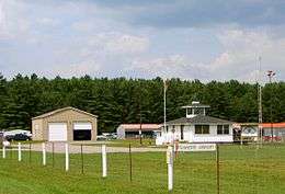
Haliburton/Stanhope Municipal Airport
| Haliburton/Stanhope Municipal Airport | |||||||||||
|---|---|---|---|---|---|---|---|---|---|---|---|
 | |||||||||||
| Summary | |||||||||||
| Airport type | Public | ||||||||||
| Operator | Township of Algonquin Highlands | ||||||||||
| Location | Haliburton, Ontario | ||||||||||
| Time zone | EST (UTC−05:00) | ||||||||||
| • Summer (DST) | EDT (UTC−04:00) | ||||||||||
| Elevation AMSL | 1,066 ft / 325 m | ||||||||||
| Coordinates | 45°06′39″N 078°38′24″W / 45.11083°N 78.64000°WCoordinates: 45°06′39″N 078°38′24″W / 45.11083°N 78.64000°W | ||||||||||
| Website | http://www.stanhopeairport.com/ | ||||||||||
| Map | |||||||||||
 CND4 Location in Ontario | |||||||||||
| Runways | |||||||||||
| |||||||||||
|
Source: Canada Flight Supplement[1] | |||||||||||
Haliburton/Stanhope Municipal Airport, (TC LID: CND4), is located 6.9 nautical miles (12.8 km; 7.9 mi) northwest of Haliburton, Ontario, Canada.
See also
References
- ↑ Canada Flight Supplement. Effective 0901Z 19 July 2018 to 0901Z 13 September 2018.
| By name | |
|---|---|
| By location indicator | |
| By province/territory | |
| By area | |
| National Airports System | |
| Related | |
| |
This article is issued from
Wikipedia.
The text is licensed under Creative Commons - Attribution - Sharealike.
Additional terms may apply for the media files.