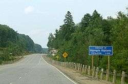
Algonquin Highlands
| Algonquin Highlands | |
|---|---|
| Township (lower-tier) | |
| Township of Algonquin Highlands | |
 | |
 Algonquin Highlands | |
| Coordinates: 45°24′N 78°45′W / 45.400°N 78.750°WCoordinates: 45°24′N 78°45′W / 45.400°N 78.750°W | |
| Country |
|
| Province |
|
| County | Haliburton |
| Government | |
| • Type | Township |
| • Mayor | Carol Moffatt |
| • Federal riding | Haliburton—Kawartha Lakes—Brock |
| • Prov. riding | Haliburton—Kawartha Lakes—Brock |
| Area[1] | |
| • Land | 1,004.76 km2 (387.94 sq mi) |
| Elevation | 443 m (1,453 ft) |
| Population (2016)[1] | |
| • Total | 2,351 |
| • Density | 2.3/km2 (6/sq mi) |
| Time zone | UTC-5 (EST) |
| • Summer (DST) | UTC-4 (EDT) |
| Canadian postal code | K0M 1J0 |
| Area code(s) | 705 |
| Website | www.algonquinhighlands.ca |
Algonquin Highlands is a township located in Haliburton County, Ontario, Canada. It has a population of 2,351. The northeastern section of the township is included in Algonquin Provincial Park.
The township was formed through the amalgamation of Stanhope and Sherborne et al. townships, the latter of which included McClintock, Livingstone, Lawrence and Nightingale. It was thereafter briefly known as the Township of Sherborne, Stanhope, McClintock, Livingstone, Lawrence and Nightingale until it was renamed to its current name in March 2001.
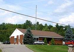
The township lacks a commercial center, but its municipal offices are located on North Shore Road, 5 km north of Carnarvon at 45°05′09″N 78°41′36″W / 45.08583°N 78.69333°W. A satellite municipal office is located in Dorset, the main street of which straddles the border of Algonquin Highlands to the east and Lake of Bays to the west.
Communities
The township includes half the village of Dorset, part of Carnarvon and the hamlets of Boshkung, Buttermilk Falls, Halls Lake, Little Hawk Lake, Maple Lake, Ox Narrows, and Oxtongue Lake.
Demographics
| Canada census – Algonquin Highlands community profile | |||
|---|---|---|---|
| 2011 | 2006 | ||
| Population: | 2156 (9.1% from 2006) | 1976 (8.2% from 2001) | |
| Land area: | 1,004.76 km2 (387.94 sq mi) | 1,002.12 km2 (386.92 sq mi) | |
| Population density: | 2.1/km2 (5.4/sq mi) | 2.0/km2 (5.2/sq mi) | |
| Median age: | 54.8 (M: 55.4, F: 54.3) | ||
| Total private dwellings: | 3878 | 3624 | |
| Median household income: | $47,450 | ||
| References: 2011[2] 2006[3] earlier[4] | |||
According to the Canada 2006 Census:[5]
- Private dwellings occupied by usual residents: 868 (total dwellings: 3624)
- Mother tongue:
- English as first language: 92.1%
- French as first language: 1.3%
- English and French as first language: 0%
- Other as first language: 6.6%
Population trend:[6]
- Population in 2011: 2156
- Population in 2006: 1976
- Population in 2001: 1827
- Population in 1996:
- Sherborne and Others (township): 487
- Stanhope (township): 1200
- Population in 1991:
- Sherborne and Others (township): 535
- Stanhope (township): 1178
See also
References
- 1 2 "Algonquin Highlands census profile". 2011 Census of Population. Statistics Canada. Retrieved 2012-02-13.
- ↑ "2011 Community Profiles". Canada 2011 Census. Statistics Canada. July 5, 2013. Retrieved 2012-02-13.
- ↑ "2006 Community Profiles". Canada 2006 Census. Statistics Canada. March 30, 2011. Retrieved 2012-02-13.
- ↑ "2001 Community Profiles". Canada 2001 Census. Statistics Canada. February 17, 2012.
- ↑ Statistics Canada 2006 Census - Algonquin Highlands community profile
- ↑ Statistics Canada: 1996, 2001, 2006 census
- "Algonquin Highlands". Geographical Names Data Base. Natural Resources Canada. Retrieved 2010-07-12.
- "Topographic Map sheets 31E2 & 31E7". Atlas of Canada. Natural Resources Canada. 2006-02-06. Archived from the original on 22 January 2009. Retrieved 2008-12-15.
External links
Places adjacent to Algonquin Highlands | ||||||||||
|---|---|---|---|---|---|---|---|---|---|---|
| ||||||||||