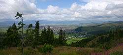
Gheorgheni
| Gheorgheni Gyergyószentmiklós | |||
|---|---|---|---|
| Municipality | |||
 | |||
| |||
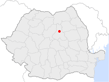 Location of Gheorgheni | |||
| Coordinates: 46°43′12″N 25°35′24″E / 46.72000°N 25.59000°ECoordinates: 46°43′12″N 25°35′24″E / 46.72000°N 25.59000°E | |||
| Country |
| ||
| County | Harghita County | ||
| Status | Municipality | ||
| Government | |||
| • Mayor | Zoltán Nagy (Hungarian Civic Party) | ||
| Area | |||
| • Total | 90.17 km2 (34.81 sq mi) | ||
| Elevation | 816 m (2,677 ft) | ||
| Population (2011) | |||
| • Total | 18,377 | ||
| • Density | 200/km2 (530/sq mi) | ||
| Ethnicity | |||
| • Hungarians | 87.54% | ||
| • Romanians | 10.79% | ||
| Time zone | UTC+2 (EET) | ||
| • Summer (DST) | UTC+3 (EEST) | ||
| Postal code | 535500 | ||
| Area code(s) | (+40) 02 66 | ||
| Vehicle registration | HR | ||
| Website |
www | ||


Gheorgheni (Romanian pronunciation: [ɡe̯orˈɡenʲ]; Hungarian: Gyergyószentmiklós Hungarian pronunciation: [ˈɟɛrɟoːsɛntmikloːʃ] (![]()
- Covacipeter / Kovácspéter
- Lacu Roșu / Gyilkostó
- Vargatac / Vargatag
- Visafolio / Visszafolyó
Nearby are two natural sites, the Red Lake and Cheile Bicazului, a narrow canyon through the Eastern Carpathian Mountains forming the border with Neamț County.
History
The city historically formed part of the Székely Land region of Transylvania province. It was first mentioned in 1332. It belonged to the Kingdom of Hungary, to the Principality of Transylvania (1557–1765) and the Grand Duchy of Transylvania (1765–1867). Between 1867–1918 it fell within the Kingdom of Hungary. Administratively, the town belonged to Gyergyószék, then, from 1876 until 1918 to the Csík County in the Austria-Hungary. After World War I, by the terms of the Treaty of Trianon of 1920, it became part of Romania and fell within Ciuc County. As a result of the Second Vienna Award, it belonged to Hungary again between 1940 and 1944. After World War II, it came under Romanian administration and became part of Romania in 1947. Between 1952 and 1960, it formed part of the Hungarian Autonomous Province, then, of the Mureș-Hungarian Autonomous Province until it was abolished in 1968. Since then, the commune is part of Harghita County.
Demographics
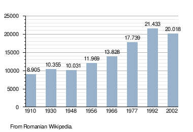
As of 2011, the city had a population of 17,705, of which 86.13% (15,250) are Székely Hungarians forming a majority. 1,988 or 11.22% are Romanians. Demographic movement according to the censuses:
Politics
The City Council has 17 members:
| Party | Seats | Current Council | |||||||||||
|---|---|---|---|---|---|---|---|---|---|---|---|---|---|
| Hungarian Civic Party | 11 | ||||||||||||
| Democratic Union of Hungarians in Romania | 6 | ||||||||||||
Twinnings


References
| Wikimedia Commons has media related to Gheorgheni. |
