Municipality of the District of Guysborough
| Guysborough | |||
|---|---|---|---|
| District municipality | |||
| Municipality of the District of Guysborough | |||
 | |||
| |||
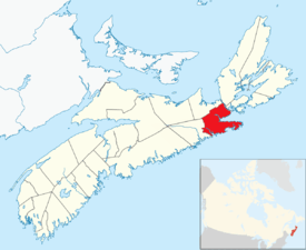 Location of the Municipality of the District of Guysborough | |||
| Coordinates: 44°26′00″N 64°35′57″W / 44.433333°N 64.599167°WCoordinates: 44°26′00″N 64°35′57″W / 44.433333°N 64.599167°W | |||
| Country |
| ||
| Province |
| ||
| County | Guysborough | ||
| Founded | 1604 | ||
| Incorporated | April 17, 1879 | ||
| Government | |||
| • Type |
Council of the Municipality of the District of Guysborough | ||
| • Municipal Seat | Guysborough | ||
| • Warden | Vernon Pitts | ||
| Area[1] | |||
| • Land | 2,116.86 km2 (817.32 sq mi) | ||
| Population (2016)[2] | |||
| • Total | 4,670 | ||
| • Change 2011-16 |
| ||
| • Census ranking | 751 of 4,870 | ||
| Electoral districts | |||
| • Federal | Cape Breton—Canso | ||
| • Provincial | Guysborough–Eastern Shore–Tracadie | ||
| Time zone | UTC-4 (AST) | ||
| • Summer (DST) | UTC-3 (ADT) | ||
| Area code(s) | 902 | ||
| Dwellings | 2,889 | ||
| Median Income* | $34,987 CDN | ||
| Website |
www | ||
| |||

Guysborough, officially named the Municipality of the District of Guysborough, is a district municipality in Guysborough County, Nova Scotia, Canada. Statistics Canada classifies the district municipality as a municipal district.
It is home to the Boylston and Salsman Provincial Parks. The parks are located between Boylston and Guysborough.
History
The area was originally called Chedabouctou and was the site of one of a fishing post of Nicolas Denys. In 1682, a permanent settlement was started by Clerbaud Bergier. A group cleared land and spent the winter with the first crops being planted in 1683. Louis-Alexandre des Friches de Meneval landed at Chedabouctou in 1687 when arriving to take up his position as governor of Acadia. The community is named after Sir Guy Carleton.[3]
Geography
Occupying the eastern half of Guysborough County, the district municipality's administrative centre is the community of Guysborough. The district completely surrounds the Town of Mulgrave and it borders the Municipality of the District of St. Mary's to the west, the Municipality of the County of Antigonish to the north and the Strait of Canso to the east.
Demographics
In the 2016 Census of Population conducted by Statistics Canada, the Municipality of the District of Guysborough recorded a population of 4,670 living in 2,197 of its 3,196 total private dwellings, a change of −6.5% from its 2011 population of 4,995. With a land area of 2,116.86 km2 (817.32 sq mi), it had a population density of 2.2/km2 (5.7/sq mi) in 2016.[2]
|
|
See also
References
- 1 2 2006 Statistics Canada Community Profile: Guysborough Municipal District, Nova Scotia
- 1 2 "Population and dwelling counts, for Canada, provinces and territories, and census subdivisions (municipalities), 2016 and 2011 censuses – 100% data (Nova Scotia)". Statistics Canada. February 8, 2017. Retrieved February 12, 2017.
- ↑ https://archive.org/stream/placenamesofprov00browuoft#page/62/mode/2up
- ↑ Statistics Canada: 1996, 2001, 2006 census
- ↑ 2011 Census
External links

- Official website
Places adjacent to Municipality of the District of Guysborough | ||||||||||
|---|---|---|---|---|---|---|---|---|---|---|
| ||||||||||
| Historical counties | |
|---|---|
| Economic regions | |
| Regional municipalities | |
| County municipalities | |
| District municipalities | |
| Towns | |
| Villages | |
| Lists | |
| |