Groton Bank Historic District
|
Groton Bank Historic District | |
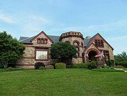 Bill Memorial Library, designed by Stephen C. Earle, is a contributing property in the district | |
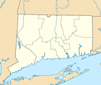  | |
| Location | Roughly bounded by the Thames River, Broad, Cottage, and Latham Sts., Groton, Connecticut |
|---|---|
| Coordinates | 41°21′24″N 72°4′55″W / 41.35667°N 72.08194°WCoordinates: 41°21′24″N 72°4′55″W / 41.35667°N 72.08194°W |
| Area | 50 acres (20 ha) |
| Architect | Multiple |
| Architectural style | Mixed (more than 2 styles from different periods) |
| NRHP reference # | 83001287[1] |
| Added to NRHP | March 24, 1983 |
The Groton Bank Historic District, also known as Groton Heights, is a primarily residential 50-acre (20 ha) historic district located in the City of Groton (within the Town of Groton) in Connecticut. The district was added to the National Register of Historic Places on March 24, 1983.[1]
The district has an inverted U-shape (formed by Thames, Broad, and Monument streets) and its boundaries are based on an 1868 map, to include an area developed mostly during 1820-1860, reflecting a period of growth when Groton was a significant whaling and shipbuilding center. Although Groton was settled by English colonists in the mid-17th century, it has few colonial-era structures, since many were destroyed during the Battle of Groton Heights in the American Revolutionary War. A number of post-independence 18th-century houses survive, including the Major Noyes Barber house, built in 1810, which is a Federal style structure.[2]
The district encompasses a well-preserved neighborhood that grew in the 18th and 19th centuries, originally as a shipbuilding center, and contains a representative cross-section of architectural styles from its periods of growth. A fine example of Italianate architecture is the Groton Heights Baptist Church, built in 1878. From later in the 19th century, a good example of Queen Anne architecture is the Thomas Miner House on Monument Street, built about 1894. Non-residential buildings in the district include a number of late 19th-century commercial blocks on Thames Street, and the Bill Memorial Library, a high-style example of Richardsonian Romanesque design by Stephen C. Earle.[2]
See also
- Fort Griswold State Park, located just south of the district
- National Register of Historic Places listings in New London County, Connecticut
References
- 1 2 National Park Service (2009-03-13). "National Register Information System". National Register of Historic Places. National Park Service.
- 1 2 Sarah J. Zimmerman and John Herzan (January 1981). "National Register of Historic Places Inventory-Nomination: Groton Bank Historic District / Groton Bank/Groton Heights". National Park Service. and Accompanying 27 photos from 1979
| Topics | |
|---|---|
| Lists by states |
|
| Lists by insular areas | |
| Lists by associated states | |
| Other areas | |
| |