Grenfell Street, Adelaide
| Grenfell Street South Australia | |
|---|---|
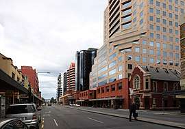 | |
| Grenfell Street, looking east from Gawler Place | |
| General information | |
| Type | Street |
| Length | 1.0 km (0.6 mi)[1] |
| Opened | 1837 |
| Major junctions | |
| Western end | King William Street |
| Pulteney Street (Hindmarsh Square), Frome Street | |
| Eastern end | East Terrace |
Grenfell Street (34°55′26″S 138°36′07″E / 34.924°S 138.602°E) is a major street in the north-east quarter of the centre[2] of the city of Adelaide, South Australia. The street runs west-east from King William Street to East Terrace. On the other side of King William Street, it continues as Currie Street. Its intersection with Pulteney Street is encircled by Hindmarsh Square.
Grenfell Street was named after Pascoe St Leger Grenfell, a British businessman and valued member of the South Australian Church Society. His significant donation of an acre of land on North Terrace was used for the construction of the Holy Trinity Church — one of the first churches built in the city.[3] Raikes Currie was Treasurer of the South Australian Church Society, and his name his used for the western continuation of Grenfell Street across King William Street. Grenfell also donated another 40 acres of country land for the use of the church as glebe lands. This land later became the suburb of Trinity Gardens.
The section of the street which runs parallel to Rundle Mall features many retail outlets, as well as the southern entrances of many of the arcades, side-streets, and eateries of the mall. Office buildings and night spots also populate the street. The eastern end is occupied on the south side by Tandanya, a museum of Indigenous Australian art, and on the north side by the East End Markets redevelopment.
Grenfell Street runs from King William Street to East Terrace, Adelaide. It is one of the intermediate–width streets of the Adelaide grid, at 1 1⁄2 chains (99 ft; 30 m) wide.
Junction list
| Location | km[4] | mi | Destinations | Notes | |
|---|---|---|---|---|---|
| Adelaide city centre | 0 | 0.0 | King William Street | Continues as Currie Street | |
| 0.2 | 0.12 | Gawler Place | |||
| 0.55 | 0.34 | Pulteney Street | |||
| 0.75 | 0.47 | Frome Street | |||
| 1.0 | 0.62 | East Terrace | Continues as the bus-only O-Bahn Busway tunnel under the Adelaide Parklands (under construction in 2016) | ||
| 1.000 mi = 1.609 km; 1.000 km = 0.621 mi | |||||
See also
![]()
References
- ↑ Google. "Grenfell Street" (Map). Google Maps. Google.
- ↑ 2003 Adelaide Street Directory, 41st Edition. UBD (A Division of Universal Press Pty Ltd). 2003. ISBN 0-7319-1441-4.
- ↑ "History of Adelaide Through Street Names - Streets Named on the 23rd May, 1837". 2005-03-04. Retrieved 2009-11-09.
- ↑ Google (11 December 2016). "Grenfell Street, Adelaide" (Map). Google Maps. Google. Retrieved 11 December 2016.
Streets and squares of Adelaide city centre | |||||||||||||
|---|---|---|---|---|---|---|---|---|---|---|---|---|---|
| |||||||||||||
| Wikimedia Commons has media related to Grenfell Street. |