Peckham Rye
| Peckham Rye | |
|---|---|
 Peckham Rye Common | |
 Peckham Rye Peckham Rye shown within Greater London | |
| Population | 13,518 (2011 Census. Ward)[1] |
| London borough | |
| Ceremonial county | Greater London |
| Region | |
| Country | England |
| Sovereign state | United Kingdom |
| Post town | LONDON |
| Postcode district | SE15/SE22 |
| Dialling code | 020 |
| Police | Metropolitan |
| Fire | London |
| Ambulance | London |
| EU Parliament | London |
| London Assembly | |
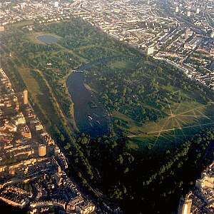
Peckham Rye is an open space and road in the London Borough of Southwark in London, England. The roughly triangular open space, managed by Southwark Council, consists of two congruent areas, with Peckham Rye Common to the north and Peckham Rye Park to the south.[2] The road Peckham Rye forms the western and eastern perimeter of the open space. Peckham Rye is also Cockney rhyming slang for tie (necktie).
Location
Peckham Rye railway station on Rye Lane is a short distance north of the open space in Peckham. To the east is Nunhead, to the south is Honor Oak and to the west is East Dulwich. Peckham Rye is a ward in Southwark, forming part of the Camberwell and Peckham constituency. There are several key roads that lead to the park including Barry Road and Friern Road. Barry Road connects the Rye with Dulwich library while Friern Road is named after a friary that once existed.
History

It was on the Rye in the 1760s that the artist William Blake claimed to have seen visions, including one of "a tree filled with angels, bright angelic wings bespangling every bough like stars.[3] " The novel The Ballad of Peckham Rye by Muriel Spark is based around this area. The park in the 50's - 70s was the site for a yearly fair. Peckham Rye is now the venue of an annual popular music festival held in May each year. https://peckhamryemusicfestival.co.uk/
The land for Peckham Rye Park was purchased by the London County Council for £51,000 and declared open on 14 May 1894. At that time the park was 54 acres (220,000 m2), 13 acres being occupied by Homestall Farm.[4] One of the first features of the new park, an ornamental 'Old English Garden' was created. It was later renamed the 'Sexby Garden' after Colonel J.J.Sexby the London County Council's first Chief Officer of Parks. It was re-developed in 1936 and the paths re-laid with york stone paving.[5]
During World War II, part of the Common became a Prisoner of War camp for Italian prisoners of war.
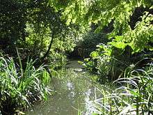
The River Peck was largely enclosed in 1823. Today, parts of this stream can still be seen on the west side of Peckham Rye Park.
Local landmarks

References
- ↑ "Southwark Ward population 2011". Neighbourhood Statistics. Office for National Statistics. Archived from the original on 21 October 2016. Retrieved 12 October 2016.
- ↑ Southwark Council - Peckham Rye Park and Common Archived 2008-08-21 at the Wayback Machine.
- ↑ "Archived copy". Archived from the original on 2012-01-18. Retrieved 2011-09-27.
- ↑ "Opening Of Peckham-Rye Park". The Times. 15 May 1894. p. 9.
- ↑ "What a Difference a Year Makes". www.londongardenstrust.org. Archived from the original on 4 March 2016. Retrieved 25 April 2018.
External links
| Districts | 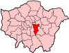 | |
|---|---|---|
| Attractions |
| |
| Markets | ||
| Bridges and tunnels | ||
| Parks and open spaces |
| |
| Constituencies | ||
| Tube and rail stations | ||
| Other topics | ||
- Know Your Ryes, local landmarks with "Rye" and "Peckham Rye" in their names