Grampound Road
| Grampound Road | |
|---|---|
 Grampound Road | |
 Grampound Road Grampound Road shown within Cornwall | |
| OS grid reference | SW915505 |
| Civil parish | |
| Unitary authority | |
| Ceremonial county | |
| Region | |
| Country | England |
| Sovereign state | United Kingdom |
| Post town | Truro |
| Postcode district | TR2 |
| EU Parliament | South West England |
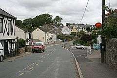
Grampound Road is a village in the parish of Ladock, Cornwall, England, 3 kilometres (1.9 mi) north-west of Grampound[1][2]
The railway station of that name was opened on 4 May 1859 and closed in 1964. A small village known as Grampound Road grew up around the railway station and continues to expand despite the station closing (along with other stations on the line) on 5 October 1964.[3]
An annual horse fair was held in the 19th-century; organised by Mr Joseph H Griggs of Nantellan. The 1882 fair, was at that time considered to be the most successful, with events including hurdle and bank jumping.[4]
See also
References
- ↑ Ordnance Survey: Landranger map sheet 200 Newquay & Bodmin (Camelford & St Austell) (Map). Ordnance Survey. ISBN 978-0-319-22938-5.
- ↑ "Grampound Road". Explore Britain. Retrieved 6 November 2017.
- ↑ "Scorrier to Lostwithiel". Cornwall Railway Gallery. Retrieved 6 November 2017.
- ↑ "Grampound-Road Horse Fair". The Cornishman (195 (185)). 6 April 1882.
Cornwall Portal | |
| Unitary authorities | |
| Major settlements |
|
| Rivers | |
| Topics | |
This article is issued from
Wikipedia.
The text is licensed under Creative Commons - Attribution - Sharealike.
Additional terms may apply for the media files.