Grade II* listed buildings in New Forest (district)
There are over 20,000 Grade II* listed buildings in England. This page is a list of these buildings in the district of New Forest in Hampshire.
New Forest
| Name | Location | Type | Completed [note 1] | Date designated | Grid ref.[note 2] Geo-coordinates |
Entry number [note 3] | Image |
|---|---|---|---|---|---|---|---|
| Abbey Mill | Beaulieu, New Forest | Mill | In use until 1940 | 8 October 1959 | SU3876102294 50°49′08″N 1°27′04″W / 50.8189°N 1.451131°W |
1156800 | 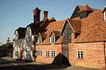 |
| Barn and attached Farm Range 60m south-east of Beufre Farmhouse | Beufre, Beaulieu, New Forest | Cistercian Monastery | possibly monastic construction | 10 June 1987 | SU3860901127 50°48′30″N 1°27′12″W / 50.808416°N 1.453411°W |
1156695 | 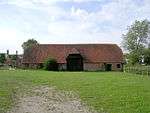 |
| Length of North of Abbey Precinct Wall 180m north of Shireburn House | Beaulieu Manor Estate, Beaulieu, New Forest | Abbey | Late 13th century | 8 October 1959 | SU3897702871 50°49′27″N 1°26′53″W / 50.824074°N 1.448004°W |
1351195 |  |
| Length of South Abbey Precinct Wall, East of Entrance to Palace House | Beaulieu, New Forest | Abbey | Late 13th century | 8 October 1959 | SU3889202436 50°49′13″N 1°26′57″W / 50.820168°N 1.449257°W |
1094412 | |
| Length of West Wall of Abbey Precinct, 100 Metres North West of Motor Museum | Beaulieu Manor Estate, Beaulieu, New Forest | Abbey | Late 13th century | 8 October 1959 | SU3851502666 50°49′20″N 1°27′17″W / 50.822261°N 1.454584°W |
1094423 | |
| Monks Well | Hilltop, Beaulieu, New Forest | Abbey | Late 13th century | 10 June 1987 | SU3972903072 50°49′33″N 1°26′14″W / 50.82583°N 1.437307°W |
1094408 | |
| Outer Gatehouse Ruins and Length of Precinct Wall Running East to Abbey Gate Cottages | Beaulieu Manor Estate, Beaulieu, New Forest | Abbey | Late 13th century | 8 October 1959 | SU3876802367 50°49′10″N 1°27′04″W / 50.819556°N 1.451024°W |
1156673 | |
| Walls to Courtyard and Bridge on South Side of Palace House | Beaulieu Manor Estate, Beaulieu, New Forest | Moat | Early 18th century | 10 June 1987 | SU3874102417 50°49′12″N 1°27′05″W / 50.820007°N 1.451402°W |
1302762 | |
| Winepress | Beaulieu Manor Estate, Beaulieu, New Forest | Abbey | Late 13th century | 8 October 1959 | SU3877902736 50°49′22″N 1°27′03″W / 50.822873°N 1.450829°W |
1351196 | |
| Boldre Grange | Battramsley, Boldre, New Forest | Country House | 1872-4 | 13 May 1987 | SZ3137398880 50°47′19″N 1°33′23″W / 50.788646°N 1.556295°W |
1351025 | |
| Burard-Neale Monument | Walhampton, Boldre, New Forest | Obelisk | 1840 | 8 April 1976 | SZ3324695881 50°45′42″N 1°31′48″W / 50.761574°N 1.529995°W |
1351049 | 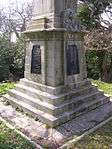 |
| Church of St John | Boldre, New Forest | Parish Church | Norman | 8 October 1959 | SZ3236499307 50°47′33″N 1°32′32″W / 50.792432°N 1.5422°W |
1094785 | 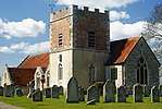 |
| Newtown Park | South Baddesley, Boldre, New Forest | Country House | 18th century | 8 October 1959 | SZ3437996954 50°46′16″N 1°30′50″W / 50.771157°N 1.513832°W |
1301405 | |
| Pylewell House | Pylewell Park, Boldre, New Forest | Country House | Mid 19th century | 13 May 1987 | SZ3536095831 50°45′40″N 1°30′00″W / 50.761°N 1.500029°W |
1351015 | 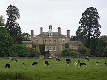 |
| Walhampton House now Walhampton School | Walhampton, Boldre, New Forest | Country House/School | Early 18th century | 13 May 1987 | SZ3316396674 50°46′07″N 1°31′52″W / 50.76871°N 1.531101°W |
1157615 |  |
| Church of St Peter | Bramshaw, New Forest | Parish Church | Mid 13th century | 8 October 1959 | SU2647916647 50°56′55″N 1°37′28″W / 50.948655°N 1.624442°W |
1301290 | 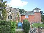 |
| Warrens House | Warrens Park, Bramshaw, New Forest | Country House | c. 1800 | 8 October 1959 | SU2749515072 50°56′04″N 1°36′36″W / 50.934445°N 1.610097°W |
1094773 | |
| Barn 30m south of Home Farm Cottages | Breamore Park, Breamore, New Forest | Threshing Barn | Late 16th century | 14 April 1986 | SU1494418776 50°58′06″N 1°47′19″W / 50.968211°N 1.788555°W |
1350956 | |
| Breamore House | Breamore Park, Breamore, New Forest | Country House | 1583 | 25 February 1958 | SU1527019029 50°58′14″N 1°47′02″W / 50.970478°N 1.783902°W |
1094935 | 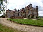 |
| Dairy Cottages | Charford, Breamore, New Forest | House | 18th century | 23 August 1979 | SU1687418931 50°58′10″N 1°45′40″W / 50.969552°N 1.761063°W |
1350918 | |
| North Charford Manor House | Charford, Breamore, New Forest | House | 16th century | 30 September 1964 | SU1706719482 50°58′28″N 1°45′30″W / 50.974501°N 1.758288°W |
1302005 | |
| Church of St Nicholas | Brockenhurst, New Forest | Parish Church | 12th century | 13 May 1987 | SU3052501766 50°48′53″N 1°34′05″W / 50.814643°N 1.568086°W |
1094740 | 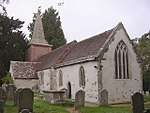 |
| Rhinefield House Hotel | Rhinefield, Brockenhurst, New Forest | Country House | 1888-90 | 28 July 1986 | SU2645203629 50°49′54″N 1°37′33″W / 50.831595°N 1.625764°W |
1094743 |  |
| Court Farm House | Damerham, New Forest | House | 14th century | 30 September 1964 | SU1099016029 50°56′37″N 1°50′42″W / 50.943598°N 1.844946°W |
1350950 |  |
| Moyles Court House now Moyles Court School | Rockford, Ellingham, Harbridge and Ibsley, New Forest | Country House/School | Late 17th century | 30 September 1964 | SU1619208513 50°52′33″N 1°46′16″W / 50.87589°N 1.771235°W |
1095007 | 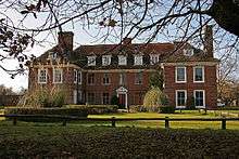 |
| Somerley House | Somerley Park Estate, Ellingham, Harbridge and Ibsley, New Forest | Country House | 1792-1795 | 30 September 1964 | SU1342207883 50°52′13″N 1°48′38″W / 50.870295°N 1.810627°W |
1350879 | 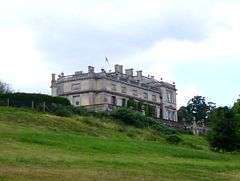 |
| Exbury House | Exbury Estate, Exbury and Lepe, New Forest | Country House | 18th century | 8 October 1959 | SU4238100054 50°47′55″N 1°24′00″W / 50.798505°N 1.400004°W |
1094360 | 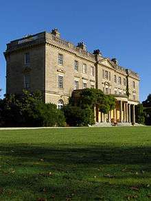 |
| Calshot Castle | Calshot, Fawley, New Forest | Castle | 1538-1541 | 10 June 1987 | SU4887702487 50°49′12″N 1°18′27″W / 50.819872°N 1.307513°W |
1302351 | 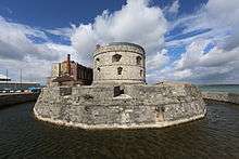 |
| Luttrell's Tower | Eaglehurst, Fawley, New Forest | Tower | c. 1780 | 8 October 1959 | SU4769000930 50°48′21″N 1°19′28″W / 50.80597°N 1.324564°W |
1094367 | 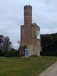 |
| Main Hangar (Calshot former RNAS Station, immediately south of Castle) | Calshot, Fawley, New Forest | Seaplane Shed (type F) | First World War | 8 April 1988 | SU4887702333 50°49′07″N 1°18′27″W / 50.818487°N 1.307533°W |
1095046 |  |
| Type G Hangar (Calshot former RNAS Station approx 130m south-west of Castle) | Calshot, Fawley, New Forest | Sports Building | 1994 | 7 January 1994 | SU4880602435 50°49′10″N 1°18′31″W / 50.81941°N 1.308527°W |
1251278 |  |
| Watersports Hangar (Calshot former RNAS Station circa 250m west of Castle) | Calshot, Fawley, New Forest | Sports Building | 1994 | 8 April 1988 | SU4872202427 50°49′10″N 1°18′35″W / 50.819345°N 1.309721°W |
1095045 | 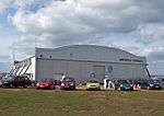 |
| Bickton Manor Farmhouse | Bickton, Fordingbridge, New Forest | Farmhouse | Late 15th century | 30 September 1964 | SU1484312476 50°54′42″N 1°47′25″W / 50.911563°N 1.790248°W |
1350971 | |
| Fryern Court | Upper Burgate, Fordingbridge, New Forest | House | Early 16th century | 30 September 1964 | SU1427516174 50°56′41″N 1°47′53″W / 50.94483°N 1.798183°W |
1166571 | 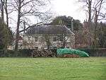 |
| Road Bridge over River Avon | Fordingbridge, New Forest | Road Bridge | 14th century or 15th century | 30 September 1964 | SU1493714215 50°55′38″N 1°47′20″W / 50.927198°N 1.78884°W |
1301381 | 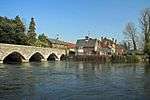 |
| The Old Manor House | Fordingbridge, New Forest | House | Late 17th century | 30 September 1964 | SU1496514387 50°55′43″N 1°47′18″W / 50.928744°N 1.788435°W |
1167019 | 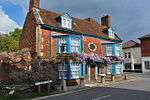 |
| Efford House | Everton, Hordle, New Forest | House | circa 1820 or before | 22 December 1953 | SZ2993694434 50°44′55″N 1°34′37″W / 50.748742°N 1.577041°W |
1275023 | |
| Venards House | North Gorley, Hyde, New Forest | House | Late 17th century | 30 September 1964 | SU1611410932 50°53′52″N 1°46′20″W / 50.897645°N 1.772237°W |
1350990 | |
| Bellevue House and adjoining Former Stables | Lymington and Pennington, New Forest | House | 18th century | 22 December 1953 | SZ3235595475 50°45′29″N 1°32′34″W / 50.757974°N 1.542663°W |
1275490 | |
| Boundary Wall and Gate at Quadrille Court | Lymington and Pennington, New Forest | Gate | 18th century | 28 October 1974 | SZ3213195401 50°45′26″N 1°32′45″W / 50.757321°N 1.545845°W |
1222298 | |
| Garden Wall to Elm Grove House | Lymington and Pennington, New Forest | Garden Wall | 18th century | 28 October 1974 | SZ3229195229 50°45′21″N 1°32′37″W / 50.755765°N 1.543592°W |
1234599 | 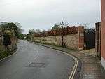 |
| Ivy House, No 63 High St and Area Railings of Twynham House | Lymington and Pennington, New Forest | House | 18th century | 22 December 1953 | SZ3221095455 50°45′28″N 1°32′41″W / 50.757802°N 1.544721°W |
1217678 |  |
| Monmouth House (including the Former Office of the Clerk to the Justices) | Lymington and Pennington, New Forest | House | Older | 22 December 1953 | SZ3215495394 50°45′26″N 1°32′44″W / 50.757256°N 1.54552°W |
1222296 |  |
| Gate with Overthrow at Monmouth House | Lymington and Pennington, New Forest | Gate | 18th century | 28 October 1974 | SZ3214995405 50°45′26″N 1°32′44″W / 50.757356°N 1.54559°W |
1274709 | |
| Parish Church of St Thomas the Apostle | Lymington and Pennington, New Forest | Parish Church | 13th century | 22 December 1953 | SZ3218195442 50°45′28″N 1°32′42″W / 50.757686°N 1.545133°W |
1217370 |  |
| Quadrille Court Nos 1, 2 and 3 | Lymington and Pennington, New Forest | House | Late 17th century | 22 December 1953 | SZ3211895375 50°45′26″N 1°32′46″W / 50.757087°N 1.546032°W |
1274710 | |
| Southend House | Lymington and Pennington, New Forest | House | Early 18th century | 22 December 1953 | SZ3220395360 50°45′25″N 1°32′41″W / 50.756948°N 1.544828°W |
1234367 | |
| 40 and 42, High Street | Lymington and Pennington, New Forest | House | Early 19th century | 28 October 1974 | SZ3242095499 50°45′29″N 1°32′30″W / 50.758186°N 1.54174°W |
1275485 | |
| 60, High Street | Lymington and Pennington, New Forest | House | late C18/early 19th century | 22 December 1953 | SZ3219295407 50°45′27″N 1°32′42″W / 50.757371°N 1.54498°W |
1275436 | |
| Foxlease | Clay Hill, Lyndhurst, New Forest | Country House | Late 18th century | 8 October 1959 | SU2991907070 50°51′45″N 1°34′35″W / 50.862369°N 1.576256°W |
1167113 |  |
| High Coxlease | Clay Hill, Lyndhurst, New Forest | Country House | 1898 | 13 May 1987 | SU2993906672 50°51′32″N 1°34′34″W / 50.858789°N 1.576005°W |
1167115 | |
| The Queen's House | Lyndhurst, New Forest | Hunting Lodge | Medieval | 8 April 1976 | SU2972808135 50°52′19″N 1°34′44″W / 50.871956°N 1.578884°W |
1167237 |  |
| Marchwood House | Marchwood Park, Marchwood, New Forest | Country House | 1820 | 10 June 1987 | SU3911209220 50°52′52″N 1°26′43″W / 50.881155°N 1.445411°W |
1094335 | |
| Manor House and attached Wall | Martin, New Forest | Farmhouse | Early 17th century | 30 September 1964 | SU0675319759 50°58′38″N 1°54′19″W / 50.977203°N 1.905185°W |
1167353 | 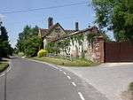 |
| Bridge House including Railings in Front | Ringwood, New Forest | House | Mid 18th century | 30 September 1964 | SU1444305235 50°50′47″N 1°47′46″W / 50.846459°N 1.796221°W |
1350899 | |
| Church of St Peter and St Paul | Ringwood, New Forest | Meeting Hall | C20 | 30 September 1964 | SU1452205360 50°50′51″N 1°47′42″W / 50.847581°N 1.795094°W |
1094964 |  |
| Manor House | Ringwood, New Forest | Manor House | Early C18, earlier core | 30 September 1964 | SU1489405490 50°50′55″N 1°47′23″W / 50.848741°N 1.789805°W |
1178471 |  |
| Meeting House | Ringwood, New Forest | Nonconformist Meeting House | 1727 | 30 September 1964 | SU1473305277 50°50′49″N 1°47′32″W / 50.846829°N 1.7921°W |
1094968 |  |
| Eyre Coote Monument | West Park Estate, Rockbourne, New Forest | Monument | 1827 | 30 September 1964 | SU1171516339 50°56′47″N 1°50′05″W / 50.946371°N 1.834617°W |
1167928 |  |
| Church of St Michael and All Angels | Sopley, New Forest | Parish Church | 13th century or earlier origins | 30 September 1964 | SZ1564696715 50°46′11″N 1°46′46″W / 50.769812°N 1.779494°W |
1302276 |  |
| Peterson's Tower | Sway, New Forest | Tower | 1879-1885 | 11 April 1975 | SZ2798796740 50°46′10″N 1°36′16″W / 50.769575°N 1.604492°W |
1296880 |  |
| Church of St Mary | Eling Hill, Totton and Eling, New Forest | Parish Church | Saxon | 8 October 1959 | SU3669212459 50°54′38″N 1°28′46″W / 50.910439°N 1.479484°W |
1094344 | 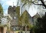 |
| Redbridge Bridge | Totton and Eling, New Forest | Road Bridge | 17th century | 8 October 1959 | SU3699513713 50°55′18″N 1°28′30″W / 50.921695°N 1.475048°W |
1351230 | 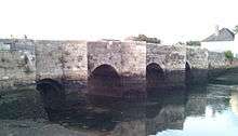 |
| Redbridge Bridge | Redbridge, Totton and Eling, New Forest | Road Bridge | 17th century | 8 October 1981 | SU3699513713 50°55′18″N 1°28′30″W / 50.921695°N 1.475048°W |
1091972 | 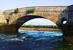 |
| The Old Rectory | Eling Hill, Totton and Eling, New Forest | Apartment | C20 | 10 June 1987 | SU3674712332 50°54′33″N 1°28′43″W / 50.909293°N 1.478715°W |
1094348 |  |
| Tide Mill | Eling Causeway, Totton and Eling, New Forest | Dam | Mid 18th century | 29 March 1959 | SU3650212520 50°54′40″N 1°28′56″W / 50.910999°N 1.482181°W |
1179062 |  |
Notes
- ↑ The date given is the date used by Historic England as significant for the initial building or that of an important part in the structure's description.
- ↑ Sometimes known as OSGB36, the grid reference is based on the British national grid reference system used by the Ordnance Survey.
- ↑ The "List Entry Number" is a unique number assigned to each listed building and scheduled monument by Historic England.
External links
![]()
This article is issued from
Wikipedia.
The text is licensed under Creative Commons - Attribution - Sharealike.
Additional terms may apply for the media files.