Grünheide (Mark)
| Grünheide (Mark) | ||
|---|---|---|
| ||
 Grünheide (Mark) Location of Grünheide (Mark) within Oder-Spree district _in_LOS.png) | ||
| Coordinates: 52°25′00″N 13°49′00″E / 52.41667°N 13.81667°ECoordinates: 52°25′00″N 13°49′00″E / 52.41667°N 13.81667°E | ||
| Country | Germany | |
| State | Brandenburg | |
| District | Oder-Spree | |
| Government | ||
| • Mayor | Arne Christiani (Ind.) | |
| Area | ||
| • Total | 125.92 km2 (48.62 sq mi) | |
| Elevation | 35 m (115 ft) | |
| Population (2017-12-31)[1] | ||
| • Total | 8,554 | |
| • Density | 68/km2 (180/sq mi) | |
| Time zone | CET/CEST (UTC+1/+2) | |
| Postal codes | 15537 | |
| Dialling codes | 03362 | |
| Vehicle registration | LOS | |
| Website | www.gemeinde-gruenheide.de | |
.png)
Grünheide (Mark) is a municipality in the Oder-Spree district, in Brandenburg, Germany. It is situated south-east of Berlin.
Geography
Division of the town
Grünheide consists of the following districts:
- Grünheide (Mark) with the villages Grünheide, Alt Buchhorst, Bergluch, Gottesbrück and Fangschleuse
- Hangelsberg
- Kagel
- Kienbaum
- Mönchwinkel
- Spreeau
Demography
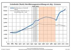 Development of Population since 1875 within the Current Boundaries (Blue Line: Population; Dotted Line: Comparison to Population Development of Brandenburg state; Grey Background: Time of Nazi rule; Red Background: Time of Communist rule)
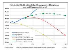 Recent Population Development and Projections (Population Development before Census 2011 (blue line); Recent Population Development according to the Census in Germany in 2011 (blue bordered line); Projection by the Brandenburg state for 2005-2030 (yellow line); Projection by the Brandenburg state for 2014-2030 (red line); Projection by the Bertelsmann Foundation for 2012-2030 (green line)
| Grünheide (Mark): Population development within the current boundaries (2017)[2] | ||||||||||||||||||||||||||||||||||||||||||||||||||||||||||||||||||||||||||||||||||||||||||||||||||||||||||||||||||||||||||||||||||||||
|---|---|---|---|---|---|---|---|---|---|---|---|---|---|---|---|---|---|---|---|---|---|---|---|---|---|---|---|---|---|---|---|---|---|---|---|---|---|---|---|---|---|---|---|---|---|---|---|---|---|---|---|---|---|---|---|---|---|---|---|---|---|---|---|---|---|---|---|---|---|---|---|---|---|---|---|---|---|---|---|---|---|---|---|---|---|---|---|---|---|---|---|---|---|---|---|---|---|---|---|---|---|---|---|---|---|---|---|---|---|---|---|---|---|---|---|---|---|---|---|---|---|---|---|---|---|---|---|---|---|---|---|---|---|---|
|
|
| ||||||||||||||||||||||||||||||||||||||||||||||||||||||||||||||||||||||||||||||||||||||||||||||||||||||||||||||||||||||||||||||||||||
See also
Personalities
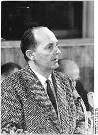
Robert Havemann Berlin Volkskammer in 1960
- Curt Herrmann (1854-1929), Impressionist, lived in the mansion with a tower in the village part of the Hangelsberg from the year 1750.
- Fritz Rasp (1891-1976), actor, lived during his time in Berlin in his own house in what is today's Mönchwinkel.
- Robert Havemann (1910-1982), chemist, communist, resistance fighter against the National Socialism and Critical Critic in the GDR. Havemann lived in his house in today's district of Grünheide from 1976 to 1979 because of his criticism of the SED
References
- ↑ "Bevölkerung im Land Brandenburg nach amtsfreien Gemeinden, Ämtern und Gemeinden 31. Dezember 2017 (Fortgeschriebene amtliche Einwohnerzahlen auf Grundlage des Zensus 2011)". Amt für Statistik Berlin-Brandenburg (in German). 2018.
- ↑ Detailed data sources are to be found in the Wikimedia Commons.Population Projection Brandenburg at Wikimedia Commons
External links
![]()
- Official website (in German)
- Tourism in Grünheide (in German)
This article is issued from
Wikipedia.
The text is licensed under Creative Commons - Attribution - Sharealike.
Additional terms may apply for the media files.