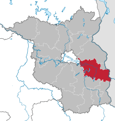
Oder-Spree
| Oder-Spree | |
|---|---|
| District | |
 | |
| Country |
|
| State | Brandenburg |
| Capital | Beeskow |
| Area | |
| • Total | 2,242 km2 (866 sq mi) |
| Population (31 December 2017)[1] | |
| • Total | 178,347 |
| • Density | 80/km2 (210/sq mi) |
| Time zone | UTC+01:00 (CET) |
| • Summer (DST) | UTC+02:00 (CEST) |
| Vehicle registration | LOS |
| Website | landkreis-oder-spree.de |
Oder-Spree is a Kreis (district) in the eastern part of Brandenburg, Germany. Neighboring are (from north clockwise) the district Märkisch-Oderland, the district-free city Frankfurt (Oder), Poland, the districts Spree-Neiße and Dahme-Spreewald, and the Bundesland Berlin.
Geography
The district is named after the two major rivers in the district - the Spree river forms a large bend within the district; the Oder river constitutes the eastern border.
History
The district was created in 1993 by merging the districts Eisenhüttenstadt, Beeskow and Fürstenwalde, and the district-free city Eisenhüttenstadt.
Demography
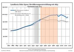 Development of Population since 1875 within the Current Boundaries (Blue Line: Population; Dotted Line: Comparison to Population Development of Brandenburg state)
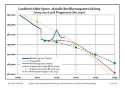 Recent Population Development and Projections (Population Development before Census 2011 (blue line); Recent Population Development according to the Census in Germany in 2011 (blue bordered line); Projection by the Brandenburg state for 2005-2030 (yellow line); Projection by the Brandenburg state for 2014-2030 (red line); Projection by the Bertelsmann Foundation for 2012-2030 (green line)
| Landkreis Oder-Spree: Population development within the current boundaries (2017)[2] | ||||||||||||||||||||||||||||||||||||||||||||||||||||||||||||||||||||||||||||||||||||||||||||||||||||||||||||||||||||||||||||||||||||||
|---|---|---|---|---|---|---|---|---|---|---|---|---|---|---|---|---|---|---|---|---|---|---|---|---|---|---|---|---|---|---|---|---|---|---|---|---|---|---|---|---|---|---|---|---|---|---|---|---|---|---|---|---|---|---|---|---|---|---|---|---|---|---|---|---|---|---|---|---|---|---|---|---|---|---|---|---|---|---|---|---|---|---|---|---|---|---|---|---|---|---|---|---|---|---|---|---|---|---|---|---|---|---|---|---|---|---|---|---|---|---|---|---|---|---|---|---|---|---|---|---|---|---|---|---|---|---|---|---|---|---|---|---|---|---|
|
|
| ||||||||||||||||||||||||||||||||||||||||||||||||||||||||||||||||||||||||||||||||||||||||||||||||||||||||||||||||||||||||||||||||||||
Coat of arms
 |
The coat of arms shows symbols for the three former districts which make up the district. In the top left quarter is the coat of arms of the Bishops of Lebus, who had their seat in Fürstenwalde. The second quarter shows the checkered bar of the Cistercian Order as the symbol of the Abbey of Neuzelle, who until 1817 owned most of the territory which later became the district Eisenhüttenstadt. The two quarters in the bottom symbolize the former district Beeskow. The three knives in the left are the symbol of the Lords of Strehla, the deer antler the symbol of the Lords of Biberstein, who in 1317 succeeded the Lords of Strehla as the Lords of Beeskow and Storkow. |
Towns and municipalities
The capital of the district is Beeskow, but Fürstenwalde (Spree) is the biggest town, with a population of 31,000 people.
| Amt-free towns | Ämter | |
|---|---|---|
|
|
2. Neuzelle 3. Odervorland |
5. Schlaubetal 6. Spreenhagen |
| 1seat of the Amt; 2town | ||
References
- ↑ "Bevölkerung im Land Brandenburg nach amtsfreien Gemeinden, Ämtern und Gemeinden 31. Dezember 2017 (Fortgeschriebene amtliche Einwohnerzahlen auf Grundlage des Zensus 2011)". Amt für Statistik Berlin-Brandenburg (in German). 2018.
- ↑ Detailed data sources are to be found in the Wikimedia Commons.Population Projection Brandenburg at Wikimedia Commons
External links
| Wikimedia Commons has media related to Oder-Spree. |
- Official website (German)
- Website Beeskow (German)
- Website Eisenhüttenstadt (German)
- Website Fürstenwalde (German)
- Website Schöneiche (English)
| Urban districts | |
|---|---|
| Rural districts | |