Gothenburg, Nebraska
| Gothenburg, Nebraska | |
|---|---|
| City | |
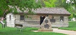 Pony Express station in Ehmen Park, Gothenburg | |
 Location of Gothenburg, Nebraska | |
| Coordinates: 40°55′54″N 100°9′34″W / 40.93167°N 100.15944°WCoordinates: 40°55′54″N 100°9′34″W / 40.93167°N 100.15944°W | |
| Country | United States |
| State | Nebraska |
| County | Dawson |
| Government | |
| • Mayor | Joyce Hudson |
| Area[1] | |
| • Total | 3.64 sq mi (9.43 km2) |
| • Land | 3.59 sq mi (9.30 km2) |
| • Water | 0.05 sq mi (0.13 km2) |
| Elevation | 2,569 ft (783 m) |
| Population (2010)[2] | |
| • Total | 3,574 |
| • Estimate (2016)[3] | 3,475 |
| • Density | 980/sq mi (380/km2) |
| Time zone | UTC-6 (Central (CST)) |
| • Summer (DST) | UTC-5 (CDT) |
| ZIP code | 69138 |
| Area code(s) | 308 |
| FIPS code | 31-19385 |
| GNIS feature ID | 0829595[4] |
| Website | http://www.ci.gothenburg.ne.us/ |
Gothenburg is a city in Dawson County, Nebraska, United States. It is part of the Lexington, Nebraska Micropolitan Statistical Area. The population was 3,574 at the 2010 census.
History
Gothenburg, Nebraska is named after Gothenburg, Sweden, and is noted for its Swedish heritage. Gothenburg, Nebraska, and Gothenburg (Swedish: Göteborg), Sweden, are believed to be the only two cities named Gothenburg in the world.[5]
Gothenburg was founded in 1882 by Olof Bergstrom. After coming to America from Sweden in 1881, Bergstrom worked for a time on the Union Pacific Railroad, then homesteaded in Dawson County near Gothenburg. He eventually became a land agent for the UP. Bergstrom selected the site that was to become Gothenburg and located a farmstead about a mile north. The Union Pacific Railroad laid out the original town of eight blocks parallel to the railroad tracks. Bergstrom made several return trips to Sweden to lead groups of settlers to Dawson County.[6]
Geography
Gothenburg is located at 40°55′54″N 100°9′34″W / 40.93167°N 100.15944°W (40.931560, -100.159381).[7]
According to the United States Census Bureau, the city has a total area of 3.64 square miles (9.43 km2), of which, 3.59 square miles (9.30 km2) is land and 0.05 square miles (0.13 km2) is water.[1]
Demographics
| Historical population | |||
|---|---|---|---|
| Census | Pop. | %± | |
| 1890 | 535 | — | |
| 1900 | 819 | 53.1% | |
| 1910 | 1,730 | 111.2% | |
| 1920 | 1,754 | 1.4% | |
| 1930 | 2,322 | 32.4% | |
| 1940 | 2,330 | 0.3% | |
| 1950 | 2,977 | 27.8% | |
| 1960 | 3,050 | 2.5% | |
| 1970 | 3,158 | 3.5% | |
| 1980 | 3,479 | 10.2% | |
| 1990 | 3,232 | −7.1% | |
| 2000 | 3,619 | 12.0% | |
| 2010 | 3,574 | −1.2% | |
| Est. 2016 | 3,475 | [3] | −2.8% |
| U.S. Decennial Census[8] 2012 Estimate[9] | |||
2010 census
As of the census[2] of 2010, there were 3,574 people, 1,494 households, and 974 families residing in the city. The population density was 995.5 inhabitants per square mile (384.4/km2). There were 1,664 housing units at an average density of 463.5 per square mile (179.0/km2). The racial makeup of the city was 97.3% White, 0.2% African American, 0.3% Native American, 0.3% Asian, 0.8% from other races, and 1.2% from two or more races. Hispanic or Latino of any race were 4.8% of the population.
There were 1,494 households of which 33.5% had children under the age of 18 living with them, 51.7% were married couples living together, 9.8% had a female householder with no husband present, 3.7% had a male householder with no wife present, and 34.8% were non-families. 31.4% of all households were made up of individuals and 16.1% had someone living alone who was 65 years of age or older. The average household size was 2.34 and the average family size was 2.94.
The median age in the city was 40.4 years. 27.1% of residents were under the age of 18; 5.7% were between the ages of 18 and 24; 22.5% were from 25 to 44; 25.2% were from 45 to 64; and 19.4% were 65 years of age or older. The gender makeup of the city was 47.3% male and 52.7% female.
2000 census
As of the census of 2000, there were 3,619 people, 1,457 households, and 989 families residing in the city. The population density was 1,422.6 people per square mile (550.1/km²). There were 1,575 housing units at an average density of 619.1 per square mile (239.4/km²). The racial makeup of the city was 97.37% White, 0.44% African American, 0.33% Native American, 0.17% Asian, 1.22% from other races, and 0.47% from two or more races. Hispanic or Latino of any race were 3.62% of the population. 45.4% were of German, 11.0% Swedish, 10.9% Irish and 8.9% American ancestry according to Census 2000.
There were 1,457 households out of which 32.3% had children under the age of 18 living with them, 55.0% were married couples living together, 9.7% had a female householder with no husband present, and 32.1% were non-families. 29.2% of all households were made up of individuals and 15.9% had someone living alone who was 65 years of age or older. The average household size was 2.41 and the average family size was 2.96.
In the city, the population was spread out with 27.1% under the age of 18, 7.5% from 18 to 24, 24.8% from 25 to 44, 20.8% from 45 to 64, and 19.8% who were 65 years of age or older. The median age was 38 years. For every 100 females, there were 87.3 males. For every 100 females age 18 and over, there were 84.7 males.
As of 2000 the median income for a household in the city was $35,990, and the median income for a family was $40,729. Males had a median income of $31,589 versus $20,162 for females. The per capita income for the city was $17,034. About 6.1% of families and 7.1% of the population were below the poverty line, including 7.0% of those under age 18 and 9.1% of those age 65 or over.
Points of interest
- The Pony Express Trail runs through Gothenburg. There are two original Pony Express Stations in Gothenburg. In 1931, a station located on the Upper 96 Ranch, four miles east of Fort McPherson in Lincoln County, was donated to the city. The station was moved to Ehmen Park in central Gothenburg.[10] A second station is still in its original location, on the Lower 96 Ranch four miles south of Gothenburg; it is open to the public on a limited basis.
- Swedish Crosses Cemetery, a cemetery where wrought iron crosses mark the graves of three children of Swedish immigrants is located two miles north and two miles west of Gothenburg. A Nebraska Historical Marker was dedicated in August 1991.
- Wild Horse Golf Club is located northwest of Gothenburg and is infamous for its high winds, fast greens, and "wooga", or the native grass that is used as the second cut. Golf Week Magazine rated it #1 "Best Course Under $50" as well as 21st Best Modern Course in the United States (2007).
- The Gothenburg Historical Museum, organized in 1980, contains many historical artifacts from the Dawson County area.
- The Sod House Museum was established in Gothenburg in 1988. The museum stands next to a full-scale replica of an authentic sod house, together with a barn, windmills and life-sized barbed wire sculptures.
Notable residents
- Chris Dishman, professional American football player, was born in Gothenburg
- Ben Kuroki, the only Japanese-American to serve in the US Army Air Force in the Pacific during World War II, was born in Gothenburg
- Jay Novacek, professional American football player, attended Gothenburg High School.
References
- 1 2 "US Gazetteer files 2010". United States Census Bureau. Archived from the original on 2012-01-24. Retrieved 2012-06-24.
- 1 2 "American FactFinder". United States Census Bureau. Retrieved 2012-06-24.
- 1 2 "Population and Housing Unit Estimates". Retrieved June 9, 2017.
- ↑ "US Board on Geographic Names". United States Geological Survey. 2007-10-25. Retrieved 2008-01-31.
- ↑ Scandinavian Leadership. "Olof Bergstrom". Retrieved 2011-01-27.
- ↑ Olof Bergstrom (Nebraska State Historical Society)
- ↑ "US Gazetteer files: 2010, 2000, and 1990". United States Census Bureau. 2011-02-12. Retrieved 2011-04-23.
- ↑ United States Census Bureau. "Census of Population and Housing". Archived from the original on May 12, 2015. Retrieved October 18, 2013.
- ↑ "Annual Estimates of the Resident Population: April 1, 2010 to July 1, 2012". Archived from the original on October 19, 2013. Retrieved October 18, 2013.
- ↑ "Division Two: Stations Between Fort Kearney and Horseshoe Creek". NPS: Pony Express Historic Resource Study. Retrieved 2010-07-18.
| Wikimedia Commons has media related to Gothenburg, Nebraska. |
External links
- Gothenburg's Homepage
- Gothenburg Public Schools
- Gothenburg Times
- Gothenburg Historical Museum
- Pony Express Station Museum
Municipalities and communities of Dawson County, Nebraska, United States | ||
|---|---|---|
| Cities | ||
| Villages | ||
| CDP | ||
| Unincorporated communities | ||
| Former communities | ||