Goonhavern
Coordinates: 50°20′31″N 5°06′40″W / 50.342°N 5.111°W
Goonhavern
| |
|---|---|
| District |
|
| Shire county | |
| Region | |
| Country | England |
| Sovereign state | United Kingdom |
| Post town | TRURO |
| Postcode district | TR4 |
| Dialling code | 01872 |
| Police | Devon and Cornwall |
| Fire | Cornwall |
| Ambulance | South Western |
| EU Parliament | South West England |
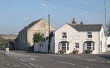
Goonhavern (Cornish: Goonhavar)[1] is a village in north Cornwall, England, UK. It is on the A3075 Newquay to Chiverton Cross road, about two miles east of Perranporth.[2] It is in the civil parish of Perranzabuloe
As well as a village store/post office, a garden centre and several campsites, there is a public house named 'The New Inn' in the centre of the village. Until recently, a model village[3] was a visitor attraction beside the B3285 just south-east of Goonhavern. A traditional village show is held in the community hall in July with prizes awarded for the local produce, flower arrangements, art, craft and photography.
A railway branch-line to Perranporth and St Agnes ran through Goonhavern from c.1905 but the line was closed by Dr Beeching's cuts in the 1960s and today there is little sign of its precise route through the village centre.
References
- ↑ Place-names in the Standard Written Form (SWF) : List of place-names agreed by the MAGA Signage Panel Archived 2013-05-15 at the Wayback Machine.. Cornish Language Partnership.
- ↑ Ordnance Survey: Landranger map sheet 200 Newquay & Bodmin ISBN 978-0-319-22938-5
- ↑ Ordnance Survey: Explorer map sheet 104 Redruth & St Agnes ISBN 978-0-319-24034-2
| Wikimedia Commons has media related to Goonhavern. |
Cornwall Portal | |
| Unitary authorities | |
| Major settlements |
|
| Rivers | |
| Topics | |