Goodmanham
| Goodmanham | |
|---|---|
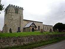
 Goodmanham village centre by the church | |
 Goodmanham Goodmanham shown within the East Riding of Yorkshire | |
| Population | 244 (2011 census)[1] |
| OS grid reference | SE889431 |
| • London | 165 mi (266 km) S |
| Civil parish |
|
| Unitary authority | |
| Ceremonial county | |
| Region | |
| Country | England |
| Sovereign state | United Kingdom |
| Post town | YORK |
| Postcode district | YO43 |
| Dialling code | 01430 |
| Police | Humberside |
| Fire | Humberside |
| Ambulance | Yorkshire |
| EU Parliament | Yorkshire and the Humber |
| UK Parliament | |
Goodmanham (historically Godmundingaham, the home of the people of Godmund mentioned in the year 627 in Bede's Historia ecclesiastica gentis Anglorum ) is a small village and civil parish in the East Riding of Yorkshire, England. It is situated approximately 2 miles (3 km) to the north-east of Market Weighton. The village is situated on the Yorkshire Wolds Way National Trail, a long distance footpath. According to the 2011 UK Census, Goodmanham parish had a population of 244,[1] an increase on the 2001 UK Census figure of 218.[2]
The village is built in a favourable position on a south-facing slope of the Yorkshire Wolds between two streams. It has a copious supply of water from numerous springs and naturally occurring limestone for building. The land is extraordinarily fertile in this region and people have lived here since prehistoric times.
History
The earliest traces of settlement are from the stone age. There are many ancient burial sites.[3] The boundaries of the village lie along the lines of ancient earthworks and these are evidence that it was a prehistoric place of worship. Near the western boundary of the village lies one of the most ancient roads of Britain, later adopted by the Romans. Settlement at this time is indicated by finds of Samian ware and coins of the period. Later in Saxon times, after the recall of the Roman legions, the village reached a position of great importance and fame. It became the site of the high shrine of Anglo Saxon Northumbria, a great temple of Woden, the father of the gods. The dramatic overthrow of this temple in 627 AD by the high priest Coifi upon the conversion of King Edwin of Northumbria is related by St Bede in his History of the English Church and People (Historia ecclesiastica gentis Anglorum).
"I have known long since" [Coifi] said, "that there is nothing in this religion that we have professed...the more I sought the truth of it the less I found...this can give us life salvation and eternal happiness...I advise that we burn the useless sanctuary – and who better than myself as an example?" [4]
So saying, he borrowed a war stallion and a war axe (in the Old English version of Bede's history it is a spear "and nom his spere on hond ") both of which were forbidden to him as a priest. He galloped to the temple and flung the weapon into the holy place. Seeing that no harm came to him, the company that followed him demolished the shrine and burned it to the ground.
It is often said that Coifi rode from Edwin's council in York to destroy the temple at Goodmanham, a distance of around 20 miles (32 km). Local tradition has it that the ride was from the king's summer camp at Londesborough, which is two miles from Goodmanham.
Although Goodmanham is very near to York, the capital of Viking England, we have no information about Goodmanham from that period. It is next found as a listing in the Domesday Book produced under William the Conqueror at the time of the Norman conquest. A few names of resident farmers are given: Colgri, Orm, Norman, William de Coleville. These names show the presence of Normans now occupying the land.
The church of All Hallows now stands on or near the site of the original pagan temple. This church dates from around 1130 AD and replaces an earlier one of wooden construction built in the Saxon period. The church was designated a Grade I listed building in 1986 and is now recorded in the National Heritage List for England, maintained by Historic England.[5] A tumulus, located to the south-west of the village, is also supposed to contain ruins. One of the many sacred wells in Britain dedicated to St Helena is located nearby.[6]
In 1823 Baines' History, Directory and Gazetteer of the County of York gave an alternative Goodmanham name of "Godmundin Graham". The village was a parish in the Wapentake of Harthill, and partly in the Liberty of St Peter. Population at the time was 220, with occupations including fifteen farmers, a boot & shoe maker, a corn miller, a shoemaker, a wheelwright, a blacksmith who was also the parish clerk, and the licensed victualler of The Star public house. A carrier operated between the village and Market Weighton and Beverley once a week.[7]
Notable people
- Richard Foster, (20 August 1856 – 5 January 1932). He emigrated to South Australia in 1880. Held various posts including Commissioner for Public Works, Minister for Industry, Minister for Works and Railways.[8]
- William Featherby, (18 August 1888 – 20 November 1958), county cricketer for Yorkshire, lived and worked locally to Goodmanham all his life.[9] He is buried in the churchyard.
References
- 1 2 UK Census (2011). "Local Area Report – Goodmanham Parish (1170211187)". Nomis. Office for National Statistics. Retrieved 18 February 2018.
- ↑ "2001 Census: Key Statistics: Parish Headcounts: Area: Goodmanham CP (Parish)". Neighbourhood Statistics. Office for National Statistics. Retrieved 16 May 2008.
- ↑ "The Tumuli of the Yorkshire Wolds". Semi-Weekly Wisconsin. Milwaukee, Wisconsin. 21 November 1866. p. 1 – via newspapers.com.
- ↑ Mee, Arthur. 1000 Heroes: Immortal Men & Women Of Every Age & Every Land.
- ↑ Historic England. "Church of All Hallows (1084132)". National Heritage List for England. Retrieved 12 August 2013.
- ↑ Paulus (5 August 2006). "St. Helen's Well (Goodmanham)". The Modern Antiquarian. Archived from the original on 29 September 2007. Retrieved 18 December 2010.
- ↑ Baines, Edward (1823). History, Directory and Gazetteer of the County of York. pp. 210–211.
- ↑ McDonald, D. I. (1981). "Foster, Richard Witty (1856–1932)". Australian Dictionary of Biography. Canberra: Australian National University. Retrieved 28 April 2013.
- ↑ "England / player / William Featherby". Cricinfo. Retrieved 16 June 2015.
- Langdale, Thomas (1822). A Topographical Dictionary of Yorkshire.
- Purvis, Rev J.S., Rector of Goodmanham (c. 1945). Goodmanham Church and Village.
- Whelan, Edna; Taylor, Ian (1989). Yorkshire Holy Wells and Sacred Springs. Northern Lights, Dunnington.
- Gazetteer – A–Z of Towns Villages and Hamlets. East Riding of Yorkshire Council. 2006. p. 6.
External links

- Goodmanham Parish Council's Website
- Goodmanham on Market Weighton's website
- The ancient parish of Goodmanham: historical and genealogical information at GENUKI.
- History of the Kingdom of Northumbria – Edwin's conversion
- Goodmanham in the Domesday Book