Goderich Airport
| Goderich Airport Goderich Municipal Airport | |||||||||||||||||||
|---|---|---|---|---|---|---|---|---|---|---|---|---|---|---|---|---|---|---|---|
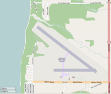 Map of the airport | |||||||||||||||||||
| Summary | |||||||||||||||||||
| Airport type | Public | ||||||||||||||||||
| Operator | Municipality of Goderich | ||||||||||||||||||
| Location | Goderich, Ontario | ||||||||||||||||||
| Time zone | EST (UTC−05:00) | ||||||||||||||||||
| • Summer (DST) | EDT (UTC−04:00) | ||||||||||||||||||
| Elevation AMSL | 709 ft / 216 m | ||||||||||||||||||
| Coordinates | 43°46′04″N 081°42′39″W / 43.76778°N 81.71083°WCoordinates: 43°46′04″N 081°42′39″W / 43.76778°N 81.71083°W | ||||||||||||||||||
| Website | www.goderich.ca/.../airport.asp | ||||||||||||||||||
| Map | |||||||||||||||||||
 CYGD Location in Ontario | |||||||||||||||||||
| Runways | |||||||||||||||||||
| |||||||||||||||||||
Goderich Airport (ICAO: CYGD), also known as Goderich Municipal Airport, is a registered aerodrome located 1.5 nautical miles (2.8 km; 1.7 mi) north of Goderich, Ontario, Canada. The aerodrome is best known as the home of Sky Harbour Aircraft, an aircraft paint shop.
The airport is classified as an airport of entry by Nav Canada and is staffed by the Canada Border Services Agency. CBSA officers at this airport currently can handle general aviation aircraft only, with no more than 15 passengers.[1]
History
During World War II, Goderich Airport hosted No. 12 Elementary Flying Training School(EFTS) for the British Commonwealth Air Training Plan, providing initial pilot training for aircrews using the Fleet Finch. Like most of the other EFTS this school was ran by a civilian flying club, in this case, the school was operated by the Kitchener-Waterloo and the County of Huron Flying Clubs.[3] No. 12 EFTS opened on October 14, 1940 and closed on July 14, 1944.
Aerodrome Information
In approximately 1942 the aerodrome was listed at 43°46′N 81°43′W / 43.767°N 81.717°W with a Var. 6 degrees W and elevation of 700 feet (213 m). The runway data lists a Turf - All Way Field - 3200'[4]
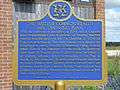 BCATP Summary Plaque
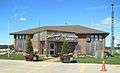 Sky Harbour Terminal - Goderich Airport
 BCATP Lancaster Cairn
.jpg) Commandos training at Sky Harbour in 1943.
Commandos training at Sky Harbour in 1943..jpg) Flyover and the BCATP buildings, between 1940-1944.
Flyover and the BCATP buildings, between 1940-1944.
References
- 1 2 Canada Flight Supplement. Effective 0901Z 19 July 2018 to 0901Z 13 September 2018.
- ↑ Synoptic/Metstat Station Information Archived December 1, 2011, at the Wayback Machine.
- ↑ Hatch, F. J. (1983). The Aerodrome of Democracy: Canada and the British Commonwealth Air Training Plan, 1939-1945. Ottawa: Directorate of History, Department of National Defence. ISBN 0660114437.
- ↑ Staff writer (c. 1942). Pilots Handbook of Aerodromes and Seaplane Bases Vol. 1. Royal Canadian Air Force. p. 115.
External links
- Goderich Municipal Airport (official site)
- Goderich Municipal / Skyharbour Airport on COPA's Places to Fly airport directory
| By name | |
|---|---|
| By location indicator | |
| By province/territory | |
| By area | |
| National Airports System | |
| Related | |
| |