Georgetown East Main Street Residential District
|
Georgetown East Main Street Residential District | |
 | |
  | |
| Location | Georgetown, Kentucky |
|---|---|
| Coordinates | 38°12′34″N 84°33′15″W / 38.20944°N 84.55417°WCoordinates: 38°12′34″N 84°33′15″W / 38.20944°N 84.55417°W |
| Area | 22 acres (8.9 ha) |
| Architect | Multiple |
| Architectural style | Classical Revival, Late Victorian, Federal |
| NRHP reference # | 78001396[1] |
| Added to NRHP | June 7, 1978 |
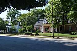
The Georgetown East Main Street Residential District is a 22 acres (8.9 ha) historic district located in Georgetown, Kentucky. The area was added to the U.S. National Register of Historic Places in 1978. It included 41 contributing buildings.[1]
The district has an irregular shape, generally running along Main St. between Warrendale Ave. and Mulberry St. [2]
A few properties in the district are:
- Scott County Post Office (1914-15)
- Georgetown Presbyterian (1865-70), brick Gothic Revival church
- James Emison House (1820), one half of a two-story double brick house[2]
References
- 1 2 National Park Service (2010-07-09). "National Register Information System". National Register of Historic Places. National Park Service.
- 1 2 Ann Bevins (July 1977). "National Register of Historic Places Inventory/Nomination: Georgetown East Main Street Residential District". National Park Service. Retrieved February 25, 2018. With 46 photos from 1973-76.
| Topics | |
|---|---|
| Lists by states |
|
| Lists by insular areas | |
| Lists by associated states | |
| Other areas | |
| |
This article is issued from
Wikipedia.
The text is licensed under Creative Commons - Attribution - Sharealike.
Additional terms may apply for the media files.