Geography of Piedmont
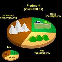
The Geography of Piedmont is that of a territory predominantly mountainous, 43.3%, but with extensive areas of hills which represent 30.3% of the territory, and of plains (26.4%).
To the north and to the west Piedmont is surrounded by the Alps, to the south by the Apennines, and to the east by the Po plain. Rocky hills are the main geographical features
To the west Piedmont borders with France, to the north with Valle d'Aosta and Switzerland, to the east with Lombardy and Emilia Romagna, and to the south with Liguria.
Piedmont is the second largest of the 20 administrative regions of Italy, after Sicily. It is broadly contiguous with the upper part of the drainage basin of the river Po which rises from the slopes of Monviso in the west of the region and is Italy’s largest river. The Po collects all the waters provided within the semicircle of mountains (Alps and Apennines) which surround the region on three sides.
From the highest peaks the land slopes down to hilly areas, (not always, though, sometimes there is a brusque transition from the mountains to the plains) and then to the upper, and then the lower Pianura Padana. The boundary between the first and the second is characterised by risorgive, springs typical of the pianura padana which supply fresh water both to the rivers and to a dense network of irrigation canals.
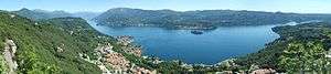
Lago Maggiore and the line of the rivers Ticino and Sesia separate Piemont from Lombardy.
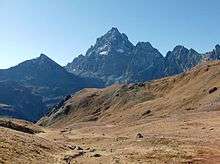
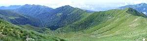
The countryside, then, is very varied: one passes from the rugged peaks of the massifs of Monte Rosa and of Gran Paradiso (national park), to the damp rice paddies of the Vercellese and Novarese; from the gentle hillsides of the Langhe and of Monferrato to the plains, often polluted and studded with a mixture of farms and industrial concerns.
Orography
Mountains
Principal mountains:
- Monte Rosa 4634 m
- Gran Paradiso 4061 m
- Monviso 3841 m
- Uia di Ciamarella 3676 m
- Monte Leone 3552 m
- Rocciamelone 3538 m
- Pierre Menue 3505 m
- Corno Bianco 3320 m
- Punta Ramiere 3303 m
- Bric Bouchet 3216 m
- Monte Matto 3097 m
- Monte Albergian 3041 m
- Rocca la Meia 2831 m
- Monte Giavino 2766 m
- Punta Marguareis 2651 m
- Monte Bram 2357 m
- Monte Barone 2044 m
- Monte Antola 1597 m
- Mottarone 1492 m
- Monte Musinè 1150 m
Valleys
As Piedmont is bounded to the north and to the west by the Alps, and to the south by the Apennines it is rich in valleys of very varied dimensions. There follows a list of some of the valleys of the region starting at the north of the boundary with Lombardy and proceeding anti-clockwise:
- Val d'Ossola
- Valle Anzasca
- Valle Antrona
- Val Bognanco
- Val Divedro
- Valle Antigorio
- Val Formazza
- Val Vigezzo
- Valsesia
- Val Mastallone
- Val d'Otro
- Val Vogna
- Val Sessera
- Valle Strona di Mosso
- Valle Cervo
- Valchiusella
- Valle dell'Orco
- Valli di Lanzo
- Val grande di Lanzo
- Val d'Ala
- Valle di Viù
- Val Ceronda
- Val di Susa
- Val Sangone
- Val Chisone
- Val Pellice
- Valle Po
- Valle Maira
- Val Varaita
- Valle Stura di Demonte
- Valle Gesso
- Val Bormida
- Val Curone
- Valle Scrivia
- Val Borbera
Hydrography
Rivers
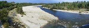
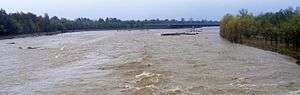
The largest river in Piedmont is the Po. Other important rivers, in order of their mean rate of discharge, include:
| Name | Length | Mean discharge |
|---|---|---|
| Ticino | 280 km | 350 m³/s |
| Tanaro | 276 km | 123 m³/s |
| Dora Baltea | 160 km | 110 m³/s |
| Sesia | 138 km | 70 m³/s |
| Toce | 84 km | 69.9 m³/s[1] |
| Stura di Demonte | 111 km | 47 m³/s |
| Bormida | 154 km | 40 m³/s |
| Orco | 100 km | 28 m³/s |
| Stura di Lanzo | 68.8 km | 26.1 m³/s[1] |
| Dora Riparia | 125 km | 25 m³/s |
| Cervo | 65 km | 21.9 m³/s[1] |
| Pellice | 53 km | 21.3 m³/s[1] |
| Agogna | 140 km | 16 m³/s |
| Bormida di Spigno | 80 km | 9 m³/s |
| Malone | 40 km | 8.8 m³/s |
| Sessera | 35 km | 7.5m³/s |
| Soana | 24 km | 7.1 m³/s[1] |
| Belbo | 86 km | 6m³/s |
| Sangone | 47 km | 3.9m³/s |
Lakes
The principal lakes of Piedmont are:
- Lago Maggiore 212 km²
- Lago d'Orta 18.2 km²
- Lago di Viverone 5.8 km²
- Lago di Mergozzo 1.85 km²
- Lago di Candia 1.52 km²
- The five lakes of the Serra di Ivrea
- Lago Sirio 1.4 km²
- Lago San Michele
- Lago Nero
- Lago Pistono
- Lago di Campagna (or Lago di Cascinette)
References
- 1 2 3 4 5 AA.VV. "Elaborato I.c/7". Piano di Tutela delle Acque - Revisione del 1º luglio 2004; Caratterizzazione bacini Idrografici (PDF). Regione Piemonte. Archived from the original (PDF) on 2012-02-25. Retrieved 2012-06-05.