Sessera Valley
| Sessera Valley | |
|---|---|
| Valle Sessera | |
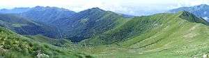 The valley seen from Cime delle Guardie | |
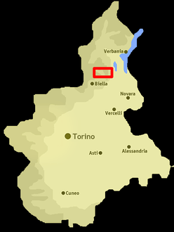 Location of the valley in Piedmont, NW Italy | |
| Floor elevation | 450–2,556 m (1,476–8,386 ft) |
| Length | around 20 km (12 mi) west east |
| Geology | |
| Type | River valley |
| Geography | |
| Location | Province of Biella, Piedmont, Italy |
| Coordinates | 45°43′00″N 8°14′00″E / 45.7167°N 8.2333°ECoordinates: 45°43′00″N 8°14′00″E / 45.7167°N 8.2333°E |
Sessera Valley (in Italian Valle Sessera) is a valley in north-east of Piedmont in the Province of Biella, Italy.
Etymology
The valley takes its name from the river Sessera, a right-hand tributary of the Sesia which flows through the valley.
Geography
The municipalities of the lowest part of the valley are Ailoche, Caprile, Coggiola, Crevacuore, Guardabosone, Pray and Portula.[1] Its highest part is used as pasture and administratively is divided in several exclaves belonging to the municipalities of the central part of the Province of Biella.[2]
Notable summits
Among the notable summits which surround the valley (al belonging to the Biellese Alps) there are:
- Monte Bo - 2.556 m
- Testone delle Tre Alpi - 2.081 m
- Cima dell'Asnas - 2.039 m
- Monte Barone - 2.044 m
- Cima delle Guardie - 2.001 m
Nature conservation
The highest part of the valley and some surrounding areas are included in a SIC (Site of Community Importance) of 10,786.73 ha called Val Sessera (code IT1130002).[3]
See also
Notes and references
- ↑ Carta Tecnica Regionale raster 1:10.000 (vers.3.0) of Regione Piemonte - 2007
- ↑ Alta Valsessera, Centro Studi Biellesi (DocBi), on-line: www.docbi.it Archived 2012-08-06 at the Wayback Machine., accessed in December 2012
- ↑ Siti di Importanza Comunitaria (SIC), Regione Piemonte, list on gis.csi.it Archived 2016-03-03 at the Wayback Machine. (accessed on April 2013)
External links
| Wikimedia Commons has media related to Valle Sessera. |