Genga, Marche
| Genga | |
|---|---|
| Comune | |
| Comune di Genga | |
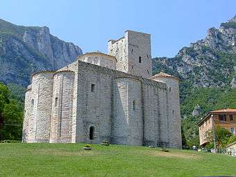 San Vittore Abbey. | |
 Genga Location of Genga in Italy | |
| Coordinates: 43°26′N 12°56′E / 43.433°N 12.933°ECoordinates: 43°26′N 12°56′E / 43.433°N 12.933°E | |
| Country | Italy |
| Region | Marche |
| Province | Ancona (AN) |
| Frazioni | Avenale, Bivio Filipponi, Camponocecchio, Capolavilla, Casamontanara, Cerqueto, Colcello, Colleponi, Falcioni, Gattuccio, Meleto, Monticelli, Palombare, Pianello, Pierosara, Rocchetta, Rosenga, San Donnino, San Fortunato, San Vittore, Trapozzo, Trinquelli, Vallemania, Valtreara |
| Government | |
| • Mayor | Raniero Nepi |
| Area | |
| • Total | 72 km2 (28 sq mi) |
| Elevation | 320 m (1,050 ft) |
| Population (2008) | |
| • Total | 1,984 |
| • Density | 28/km2 (71/sq mi) |
| Demonym(s) | Gengarini |
| Time zone | UTC+1 (CET) |
| • Summer (DST) | UTC+2 (CEST) |
| Postal code | 60040 |
| Dialing code | 0732 |
| Patron saint | St. Clemens |
| Saint day | November 23 |
| Website | Official website |
Genga is a town and comune of province of Ancona in the Italian region of the Marche, on the Sentino river about 7 kilometres (4 mi) downstream and east of Sassoferrato and 12 kilometres (7 mi) north of Fabriano.
The town is best known as the ancestral home of the noble family of the della Genga, the most famous member of which was Pope Leo XII.
Main sights
- the Romanesque abbey at S. Vittore alle Chiuse (11th century).
- the Roman Bridge in the same hamlet, about 8 kilometres (5 mi) southeast of town.
- Museum of the church of San Clemente. It houses a triptych and a 15th-century banner by Antonio da Fabriano.
- Spaelaeo-Palaeontologic Museum, including a famous fossil of an Ichthyosaur found in the area in 1976.
The Frasassi Caves, about 5 kilometres (3 mi) south-southeast, are among the most visited natural curiosities in central Italy.
External links
![]()

This article is issued from
Wikipedia.
The text is licensed under Creative Commons - Attribution - Sharealike.
Additional terms may apply for the media files.