Geneseo, Kansas
| Geneseo, Kansas | |
|---|---|
| City | |
 Location within Rice County and Kansas | |
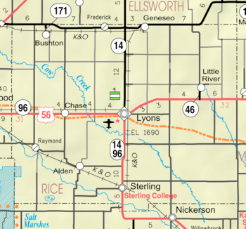 KDOT map of Rice County (legend) | |
| Coordinates: 38°30′58″N 98°09′24″W / 38.51611°N 98.15667°WCoordinates: 38°30′58″N 98°09′24″W / 38.51611°N 98.15667°W | |
| Country | United States |
| State | Kansas |
| County | Rice |
| Township | Victoria |
| Area[1] | |
| • Total | 0.58 sq mi (1.50 km2) |
| • Land | 0.58 sq mi (1.50 km2) |
| • Water | 0 sq mi (0 km2) |
| Elevation | 1,755 ft (535 m) |
| Population (2010)[2] | |
| • Total | 267 |
| • Estimate (2016)[3] | 264 |
| • Density | 460/sq mi (180/km2) |
| Time zone | UTC-6 (Central (CST)) |
| • Summer (DST) | UTC-5 (CDT) |
| ZIP code | 67444 |
| Area code | 620 |
| FIPS code | 20-26075 [4] |
| GNIS ID | 475564[5] |
Geneseo is a city in Rice County, Kansas, United States.[5] As of the 2010 census, the city population was 267.[6]
History
For millennia, the land now known as Kansas was inhabited by Native Americans. In 1803, most of modern Kansas was secured by the United States as part of the Louisiana Purchase. In 1854, the Kansas Territory was organized, then in 1861 Kansas became the 34th U.S. state. In 1867, Rice County was founded.
Geneseo was founded in 1886.[7] It was named after Geneseo, Illinois.[8]
Geography
According to the United States Census Bureau, the city has a total area of 0.58 square miles (1.50 km2), all of it land.[1]
Climate
The climate in this area is characterized by hot, humid summers and generally mild to cool winters. According to the Köppen Climate Classification system, Geneseo has a humid subtropical climate, abbreviated "Cfa" on climate maps.[9]
Demographics
| Historical population | |||
|---|---|---|---|
| Census | Pop. | %± | |
| 1890 | 399 | — | |
| 1900 | 466 | 16.8% | |
| 1910 | 566 | 21.5% | |
| 1920 | 561 | −0.9% | |
| 1930 | 536 | −4.5% | |
| 1940 | 632 | 17.9% | |
| 1950 | 660 | 4.4% | |
| 1960 | 558 | −15.5% | |
| 1970 | 453 | −18.8% | |
| 1980 | 496 | 9.5% | |
| 1990 | 382 | −23.0% | |
| 2000 | 272 | −28.8% | |
| 2010 | 267 | −1.8% | |
| Est. 2016 | 264 | [3] | −1.1% |
| U.S. Decennial Census | |||
2010 census
As of the census[2] of 2010, there were 267 people, 129 households, and 73 families residing in the city. The population density was 460.3 inhabitants per square mile (177.7/km2). There were 169 housing units at an average density of 291.4 per square mile (112.5/km2). The racial makeup of the city was 95.9% White, 0.7% from other races, and 3.4% from two or more races. Hispanic or Latino of any race were 4.1% of the population.
There were 129 households of which 16.3% had children under the age of 18 living with them, 42.6% were married couples living together, 8.5% had a female householder with no husband present, 5.4% had a male householder with no wife present, and 43.4% were non-families. 39.5% of all households were made up of individuals and 13.9% had someone living alone who was 65 years of age or older. The average household size was 2.07 and the average family size was 2.70.
The median age in the city was 52.8 years. 17.6% of residents were under the age of 18; 4.6% were between the ages of 18 and 24; 16.8% were from 25 to 44; 39.7% were from 45 to 64; and 21.3% were 65 years of age or older. The gender makeup of the city was 57.3% male and 42.7% female.
2000 census
As of the census[4] of 2000, there were 272 people, 136 households, and 81 families residing in the city. The population density was 472.7 people per square mile (181.1/km²). There were 171 housing units at an average density of 297.2 per square mile (113.8/km²). The racial makeup of the city was 97.79% White, 0.37% African American, 0.74% Native American, 0.74% Asian, and 0.37% from two or more races. Hispanic or Latino of any race were 0.37% of the population.
There were 136 households out of which 21.3% had children under the age of 18 living with them, 46.3% were married couples living together, 8.8% had a female householder with no husband present, and 40.4% were non-families. 37.5% of all households were made up of individuals and 18.4% had someone living alone who was 65 years of age or older. The average household size was 2.00 and the average family size was 2.60.
In the city, the population was spread out with 18.4% under the age of 18, 5.9% from 18 to 24, 20.6% from 25 to 44, 29.8% from 45 to 64, and 25.4% who were 65 years of age or older. The median age was 48 years. For every 100 females, there were 107.6 males. For every 100 females age 18 and over, there were 101.8 males.
The median income for a household in the city was $20,795, and the median income for a family was $29,250. Males had a median income of $27,083 versus $20,000 for females. The per capita income for the city was $21,998. About 8.2% of families and 9.7% of the population were below the poverty line, including 7.1% of those under the age of eighteen and 5.9% of those sixty five or over.
Education
Geneseo is served by USD 327 Ellsworth-Kanopolis-Geneseo. School unification consolidated Ellsworth, Geneseo and Kanopolis schools into USD 327. The district high school is located in Ellsworth. The Ellsworth High School mascot is Ellsworth Bearcats.[10]
Geneseo High School was closed through school unification in 1980. The Geneseo High School mascot was Geneseo Dragons.[11]
Media
- Newspaper
The Geneseo Journal was originally called the Geneseo Herald from 1887 to 1899, then it became Geneseo Post from 1908 to 1909. From 1979 through 1983 it was known as Geneseo Galaxy.[12]
Notable people
- John S. Gibson, Jr. - One of the nation's youngest mayors who later moved to California and became a member of the Los Angeles City Council
See also
References
- 1 2 "US Gazetteer files 2010". United States Census Bureau. Archived from the original on 2012-01-24. Retrieved 2012-07-06.
- 1 2 "American FactFinder". United States Census Bureau. Retrieved 2012-07-06.
- 1 2 "Population and Housing Unit Estimates". Retrieved June 9, 2017.
- 1 2 "American FactFinder". United States Census Bureau. Archived from the original on 2013-09-11. Retrieved 2008-01-31.
- 1 2 U.S. Geological Survey Geographic Names Information System: Geneseo
- ↑ "2010 City Population and Housing Occupancy Status". U.S. Census Bureau. Archived from the original on July 21, 2011. Retrieved September 26, 2011.
- ↑ Kansas State Historical Society (1916). Biennial Report of the Board of Directors of the Kansas State Historical Society. Kansas State Printing Plant. p. 273.
- ↑ "Profile for Geneseo, Kansas". ePodunk. Retrieved 22 June 2014.
- ↑ Climate Summary for Geneseo, Kansas
- ↑ "USD 327". USD 327. Retrieved 4 January 2017.
- ↑ "Western Kansas Basketball Results", Great Bend Tribune, 13 December 1967, p.5.
- ↑ "Publications". Kansas State Historical Society. Retrieved 15 October 2009.
Further reading
External links
| Wikimedia Commons has media related to Geneseo, Kansas. |
- City
- Schools
- USD 327, local school district
- Maps
- Geneseo City Map, KDOT
Municipalities and communities of Rice County, Kansas, United States | ||
|---|---|---|
| Cities | 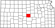 | |
| Unincorporated communities | ||
| Townships | ||