Geita District
| Geita District | |
|---|---|
| District | |
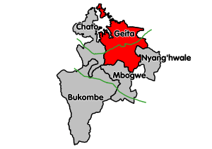 Map showing Geita District's location within Geita Region. | |
 Geita District Geita District  Geita District Geita District (Africa) .svg.png) Geita District Geita District (Earth) | |
| Coordinates: 02°55′00″S 032°15′00″E / 2.91667°S 32.25000°ECoordinates: 02°55′00″S 032°15′00″E / 2.91667°S 32.25000°E | |
| Country | Tanzania |
| Region | Geita |
| District | Geita |
| Population (2012)[1] | |
| • Total | 807,619 |
| Time zone | UTC+3 (EAT) |
| Postcode | 30xxx |
| Area code(s) | 028 |
| Website | District website |
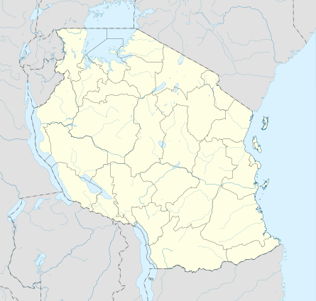
Geita District is located in the Geita Region of Tanzania.[2] According to the 2012 census, the population of the district was 807,619.[1] The district is bordered to the east by Mwanza Region and Nyang'hwale District, to the south by Shinyanga Region and Mbogwe District, and to the west by Chato District.
History
Prior to the creation of the Geita Region in March 2012,[3] the Geita District was part of the Mwanza Region.[4]
Transport
Road
Paved trunk road T4 from Mwanza to Bukoba passes through the district from east to west.[5]
Economy
Mining
Geita Gold Mine is located within Geita District, 4km west of the town of Geita. The mine is currently being owned and managed by AngloGold Ashanti.[6]
Tourism
Rubondo Island National Park is located on an island in Lake Victoria that is a part of Geita District. It can be reached by ferry from Nkome, a village in the north of the district.[7]
Wards
As of the 2012 census, Geita District was divided administratively into 35 wards:[1]
- Bugalama
- Bugulula
- Bujula
- Bukoli
- Bukondo
- Bulela
- Bung'wangoko
- Busanda
- Butobela
- Chigunga
- Ihanamilo
- Isulwabutundwe
- Kagu
- Kakubilo
- Kalangalala
- Kamena
- Kamhanga
- Kasamwa
- Kaseme
- Katoma
- Katoro
- Lubanga
- Lwamgasa
- Lwezera
- Mtakuja
- Nkome
- Nyachiluluma
- Nyakagomba
- Nyakamwaga
- Nyamalimbe
- Nyamigota
- Nyanguku
- Nyarugusu
- Nzera
- Senga
References
- 1 2 3 Population Distribution by Administrative Units, United Republic of Tanzania, 2013 Archived May 2, 2013, at the Wayback Machine.
- ↑ "Tanzania: State Gazettes New Regions, Districts". Daily News. Dar es Salaam, Tanzania. 9 March 2012. Archived from the original on August 23, 2012.
- ↑ Staff (9 March 2012). "Tanzania: State Gazettes New Regions, Districts". Daily News. Dar es Salaam, Tanzania. Archived from the original on August 23, 2012.
- ↑ (in Swahili)"Taarifa Kwa Umma: Notisi Ya Kuanzisha Mikoa Na Wilaya", Ofisi Ya Waziri Mkuu Tawala Za Mikoa Na Serikali Za Mitaa, 9 September 2011
- ↑ "Geita Roads Network" (PDF). Tanroads. Retrieved 21 September 2016.
- ↑ "AngloGold Ashanti in Tanzania". AngloGold Ashanti. Retrieved 21 September 2016.
- ↑ "Rubondo Island National Park". Tanzania National Parks. Archived from the original on 29 September 2012. Retrieved 21 September 2016.