Garrett, Pennsylvania
| Garrett, Pennsylvania | |
|---|---|
| Borough | |
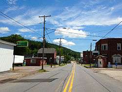 Garrett, Pennsylvania, looking east on PA 653 (Jackson St). | |
| Motto(s): The Town that goes on and on | |
 Location of Garrett in Somerset County, Pennsylvania. | |
 Location of Garrett in Somerset County, Pennsylvania. | |
| Coordinates: 39°51′49″N 79°03′40″W / 39.86361°N 79.06111°WCoordinates: 39°51′49″N 79°03′40″W / 39.86361°N 79.06111°W | |
| Country | United States |
| State | Pennsylvania |
| County | Somerset |
| Settled | 1869 |
| Incorporated | 1900 |
| Government | |
| • Type | Borough Council |
| Area[1] | |
| • Total | 0.51 sq mi (1.31 km2) |
| • Land | 0.51 sq mi (1.31 km2) |
| • Water | 0.00 sq mi (0.00 km2) |
| Population (2010) | |
| • Total | 456 |
| • Estimate (2016)[2] | 431 |
| • Density | 851.78/sq mi (329.10/km2) |
| Time zone | UTC-5 (Eastern (EST)) |
| • Summer (DST) | UTC-4 (EDT) |
| Zip code | 15542 |
| Area code(s) | 814 |
| FIPS code | 42-28520 |
Garrett is a borough in Somerset County, Pennsylvania, United States. It is part of the Johnstown, Pennsylvania Metropolitan Statistical Area. The population was 449 at the 2000 census.
Geography
Garrett is located at 39°51′49″N 79°3′40″W / 39.86361°N 79.06111°W (39.863563, -79.061159).[3]
According to the United States Census Bureau, the borough has a total area of 0.7 square miles (1.8 km2).
Garrett sits at the confluence of the Buffalo Creek and the Casselman River. The Casselman River is believed to be named for the Landgraviate of Hesse-Kassel or Hesse-Cassel in Germany. An imperial immediacy (German: Reichsfreiheit or Reichsunmittelbarkeit) which was a privileged feudal and political status, a form of statehood, which a city, religious entity or feudal principality of minor lordship could attain within the Holy Roman Empire.
Demographics
| Historical population | |||
|---|---|---|---|
| Census | Pop. | %± | |
| 1880 | 253 | — | |
| 1900 | 488 | — | |
| 1910 | 848 | 73.8% | |
| 1920 | 850 | 0.2% | |
| 1930 | 878 | 3.3% | |
| 1940 | 872 | −0.7% | |
| 1950 | 761 | −12.7% | |
| 1960 | 617 | −18.9% | |
| 1970 | 616 | −0.2% | |
| 1980 | 563 | −8.6% | |
| 1990 | 520 | −7.6% | |
| 2000 | 449 | −13.7% | |
| 2010 | 456 | 1.6% | |
| Est. 2016 | 431 | [2] | −5.5% |
| Sources:[4][5][6] | |||
As of the census[5] of 2000, there were 449 people, 168 households, and 128 families residing in the borough. The population density was 606.3 people per square mile (234.3/km²). There were 180 housing units at an average density of 243.0 per square mile (93.9/km²). The racial makeup of the borough was 99.55% White, and 0.45% from two or more races.
There were 168 households out of which 33.3% had children under the age of 18 living with them, 61.3% were married couples living together, 10.7% had a female householder with no husband present, and 23.8% were non-families. 21.4% of all households were made up of individuals and 12.5% had someone living alone who was 65 years of age or older. The average household size was 2.67 and the average family size was 3.07.
In the borough the population was spread out with 26.9% under the age of 18, 10.0% from 18 to 24, 26.5% from 25 to 44, 20.0% from 45 to 64, and 16.5% who were 65 years of age or older. The median age was 34 years. For every 100 females there were 98.7 males. For every 100 females age 18 and over, there were 91.8 males.
The median income for a household in the borough was $24,609, and the median income for a family was $27,375. Males had a median income of $23,542 versus $15,625 for females. The per capita income for the borough was $10,935. About 12.1% of families and 15.8% of the population were below the poverty line, including 17.3% of those under age 18 and 15.3% of those age 65 or over.
Notable landmarks in Garrett include a 10 MW wind farm, the first large-scale wind facility constructed in the eastern U.S.
History
Garrett was first settled in 1869 and was incorporated in 1900.
Garrett is named for the president of the Baltimore and Ohio Railroad John Work Garrett.[7] John W. Garrett served as president of the Baltimore and Ohio Railroad from 1858–1884 and was born in Baltimore, Maryland on July 31, 1820. He was the second son of Elizabeth Stouffer and Robert Garrett. He married Rachel Ann Harrison, the daughter of Thomas Harrison, a Baltimore merchant. They had one daughter, Mary and two sons Robert and Thomas Harrison Garrett.
The Western Maryland Railroad ran in an East to West direction on the Brooklyn side of Garrett. It is the current site of the Great Allegheny Passage. A 150-mile system of biking and hiking trails connecting Cumberland, Maryland and Pittsburgh. Which was constructed on the former Western Maryland railroad bed. The Connellsville Extension of the Western Maryland Railroad was built west from Cumberland, Maryland, to Connellsville, Pennsylvania, beginning around 1906 and was completed in 1912. In 1964, the Chesapeake and Ohio Railway (C&O) and the Baltimore and Ohio Railroad (B&O) jointly filed for permission to acquire control of the Western Maryland Railway with the Interstate Commerce Commission (ICC). In 1973, as part of the Chessie System, the Western Maryland ownership went to C&O and it was operated by the B&O. In 1987, it was merged into the C&O which itself became part of CSX Transportation.
References
- ↑ "2016 U.S. Gazetteer Files". United States Census Bureau. Retrieved Aug 14, 2017.
- 1 2 "Population and Housing Unit Estimates". Retrieved June 9, 2017.
- ↑ "US Gazetteer files: 2010, 2000, and 1990". United States Census Bureau. 2011-02-12. Retrieved 2011-04-23.
- ↑ "Census of Population and Housing". U.S. Census Bureau. Archived from the original on 12 May 2015. Retrieved 11 December 2013.
- 1 2 "American FactFinder". United States Census Bureau. Archived from the original on 2013-09-11. Retrieved 2008-01-31.
- ↑ "Incorporated Places and Minor Civil Divisions Datasets: Subcounty Resident Population Estimates: April 1, 2010 to July 1, 2012". Population Estimates. U.S. Census Bureau. Archived from the original on 17 June 2013. Retrieved 11 December 2013.
- ↑ Gannett, Henry (1905). The Origin of Certain Place Names in the United States. Govt. Print. Off. p. 135.
Municipalities and communities of Somerset County, Pennsylvania, United States | ||
|---|---|---|
| Boroughs | 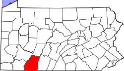 | |
| Townships | ||
| CDPs | ||
| Unincorporated communities | ||
| Footnotes | ‡This populated place also has portions in an adjacent county or counties | |