Addison Township, Somerset County, Pennsylvania
| Addison Township, Pennsylvania | |
|---|---|
| Township | |
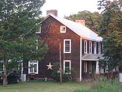 The Wable-Augustine Tavern, a historic site in the township | |
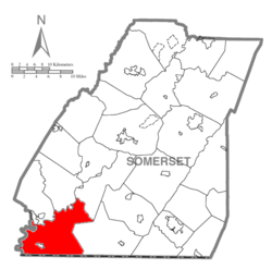 Map of Somerset County, Pennsylvania Highlighting Addison Township | |
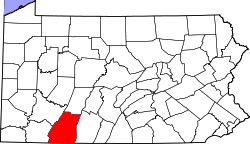 Map of Somerset County, Pennsylvania | |
| Country | United States |
| State | Pennsylvania |
| County | Somerset |
| Settled | 1764 |
| Incorporated | 1800 |
| Area[1] | |
| • Total | 63.20 sq mi (163.69 km2) |
| • Land | 61.40 sq mi (159.01 km2) |
| • Water | 1.80 sq mi (4.67 km2) |
| Population (2010) | |
| • Total | 974 |
| • Estimate (2016)[2] | 937 |
| • Density | 15.26/sq mi (5.89/km2) |
| Time zone | UTC-5 (Eastern (EST)) |
| • Summer (DST) | UTC-4 (EDT) |
| FIPS code | 42-111-00404 |
Addison Township is a township in Somerset County, Pennsylvania, United States. The population was 1,019 at the 2000 census. It is part of the Johnstown, Pennsylvania Metropolitan Statistical Area.
History
The Wable-Augustine Tavern was added to the National Register of Historic Places in 1995.[3]
Geography
According to the United States Census Bureau, the township has a total area of 63.4 square miles (164 km2), of which, 61.7 square miles (160 km2) of it is land and 1.7 square miles (4.4 km2) of it (2.74%) is water.
Demographics
| Historical population | |||
|---|---|---|---|
| Census | Pop. | %± | |
| 2010 | 974 | — | |
| Est. 2016 | 937 | [2] | −3.8% |
| U.S. Decennial Census[4] | |||
As of the census[5] of 2000, there were 1,019 people, 435 households, and 301 families residing in the township. The population density was 16.5 people per square mile (6.4/km²). There were 964 housing units at an average density of 15.6/sq mi (6.0/km²). The racial makeup of the township was 99.71% White, 0.10% Native American, 0.10% Asian, 0.10% from other races. Hispanic or Latino of any race were 0.20% of the population.
There were 435 households out of which 23.7% had children under the age of 18 living with them, 59.3% were married couples living together, 6.0% had a female householder with no husband present, and 30.6% were non-families. 27.4% of all households were made up of individuals and 14.7% had someone living alone who was 65 years of age or older. The average household size was 2.33 and the average family size was 2.78.
In the township the population was spread out with 19.9% under the age of 18, 5.7% from 18 to 24, 23.9% from 25 to 44, 28.7% from 45 to 64, and 21.8% who were 65 years of age or older. The median age was 45 years. For every 100 females there were 105.9 males. For every 100 females age 18 and over, there were 106.6 males.
The median income for a household in the township was $29,792, and the median income for a family was $33,654. Males had a median income of $28,750 versus $19,688 for females. The per capita income for the township was $16,889. About 11.1% of families and 14.3% of the population were below the poverty line, including 13.5% of those under age 18 and 18.8% of those age 65 or over.
References
- ↑ "2016 U.S. Gazetteer Files". United States Census Bureau. Retrieved Aug 14, 2017.
- 1 2 "Population and Housing Unit Estimates". Retrieved June 9, 2017.
- ↑ National Park Service (2010-07-09). "National Register Information System". National Register of Historic Places. National Park Service.
- ↑ "Census of Population and Housing". Census.gov. Retrieved June 4, 2016.
- ↑ "American FactFinder". United States Census Bureau. Archived from the original on 2013-09-11. Retrieved 2008-01-31.
Municipalities and communities of Somerset County, Pennsylvania, United States | ||
|---|---|---|
| Boroughs | | |
| Townships | ||
| CDPs | ||
| Unincorporated communities | ||
| Footnotes | ‡This populated place also has portions in an adjacent county or counties | |
Coordinates: 39°46′00″N 79°17′59″W / 39.76667°N 79.29972°W