Garhakota
| Garhakota | |
|---|---|
| city | |
 Garhakota Location in Madhya Pradesh, India  Garhakota Garhakota (India) | |
| Coordinates: 23°46′N 79°09′E / 23.77°N 79.15°ECoordinates: 23°46′N 79°09′E / 23.77°N 79.15°E | |
| Country |
|
| State | Madhya Pradesh |
| District | Sagar |
| Elevation | 373 m (1,224 ft) |
| Population (2011) | |
| • Total | 32,726 |
| Languages | |
| • Official | Hindi |
| Time zone | UTC+5:30 (IST) |
| ISO 3166 code | IN-MP |
| Vehicle registration | MP |
Garhakota is a city and a municipality in Sagar district in the state of Madhya Pradesh, India.
Geography
Garhakota is located at 23°46′N 79°09′E / 23.77°N 79.15°E.[1] It has an average elevation of 373 metres (1,223 feet).
Demographics
As of 2001 India census,[2] Garhakota had a population of 26,877. Males constitute 52% of the population and females 48%. Garhakota has an average literacy rate of 67%, higher than the national average of 59.5%: male literacy is 77%, and female literacy is 57%. In Garhakota, 16% of the population is under 6 years of age.
Many archeological surveys revealed that it has been a place of importance for many civilizations.
Tourism
- Shri Parsvanath Digamber Jain Atishaya Kshetra, Pateriaji
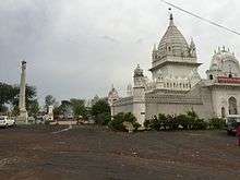
This temple is more than 200 years old, built by Seth Radha Kishanjun Shah out of his one day earning from the cotton trade in 1782 A.D. (V.S. 1839). The principal deity of Pateria is Lord Parsvanath (The 23rd Teerthankar). This idol is two metres in height in Padmasana posture build in Black Stone with three serpent hoods. The spire of this temple is 27 metres high surrounded by a thick wall. [3]
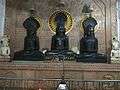
- Shri Dig. Jain Chaudhari Mandir
This temple was built in 1891(V.S. 1948), has eighteen metre high spire. It consist 63 idols, moolnayak of this temple is an idol of Lord Parsvanath having 1,000 serpent hoods.
- Garhakota Fort,
The nearby Garhakota fort has rivers Sunar and Gadhairi on the two sides. It covers 11 acres. This fort was the residence of Rajput Kings of Garhakota. In 19th century, during the first freedom struggle of India in 1857, Rani of Jhansi Lakshmi Bai wrote a letter to Raja Mardan Singh Bahadur of Garhakota to prepare against British troops and to stop them at Sagar. Mardan Singh and Gunthai Pateriya killed in the battle. The fort was raided and demolished by Sir Hugh Rose in 1858 in the course of Ghadar.[4]
- Pateriya Fort, JagannathJi Temple
Another fort was situated behind the main fort which was the residence of Pateriyas. They were Zameendars of Pateriya Riyasat and close associates of the Rajput Kings of Garhakota. They were Jijhotiya Brahmins. "Pateriya" was not their original surname. That was their title or "upadhi" which was awarded by the Bundela King Jujhar Singh for their victorious participation in battles against the Moguls in 17th century. Pateriya Fort, Gopalji Krishna temple, Jagannathji Pateriya Vishnu temple and Shiv temple were built in 16th century AD. The Pateriya fort was abandoned after the Ghadar rampage. Land records evidence are available at Revenue Office of Rehli tehsil; 1874 acres in name of Munna Lal Patriya of Garhakota, after the independence in 1947.
 Pateriaji main vedi
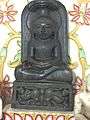 Pateriaji Garbha Griha Bhattarka Mahendrakirti
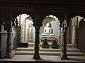 Garhakota Chaudary mandir main vedi
References
- ↑ Falling Rain Genomics, Inc - Garhakota
- ↑ "Census of India 2001: Data from the 2001 Census, including cities, villages and towns (Provisional)". Census Commission of India. Archived from the original on 2004-06-16. Retrieved 2008-11-01.
- ↑ http://jain.org.in/tirth-Pateria%20M.%20P.html
- ↑ The Revolt in Central India 1857-59 By Reginald George Burton, India. Army. Intelligence Branch, Government Monotype Press, 1908 p. 98