Garfield Township, Jackson County, Kansas
| Garfield Township | |
|---|---|
| Township | |
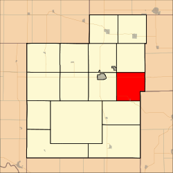 Location in Jackson County | |
| Coordinates: 39°26′00″N 95°37′36″W / 39.43333°N 95.62667°WCoordinates: 39°26′00″N 95°37′36″W / 39.43333°N 95.62667°W | |
| Country | United States |
| State | Kansas |
| County | Jackson |
| Area | |
| • Total | 34 sq mi (88.06 km2) |
| • Land | 33.83 sq mi (87.62 km2) |
| • Water | 0.17 sq mi (0.43 km2) 0.49% |
| Elevation | 1,112 ft (339 m) |
| Population (2000) | |
| • Total | 624 |
| • Density | 18.4/sq mi (7.1/km2) |
| GNIS feature ID | 0478198 |
Garfield Township is a township in Jackson County, Kansas, USA. As of the 2000 census, its population was 624.
Geography
Garfield Township covers an area of 34 square miles (88.06 square kilometers); of this, 0.17 square miles (0.43 square kilometers) or 0.49 percent is water. The stream of Bills Creek runs through this township.
Cities and towns
- Denison (vast majority)
Unincorporated towns
- Carbon (historical)
(This list is based on USGS data and may include former settlements.)
Adjacent townships
- Straight Creek Township (north)
- Kapioma Township, Atchison County (east)
- Delaware Township, Jefferson County (southeast)
- Cedar Township (south)
- Franklin Township (west)
- Liberty Township (northwest)
Major highways
- K-16
- K-116
References
External links
Municipalities and communities of Jackson County, Kansas, United States | ||
|---|---|---|
| Cities | 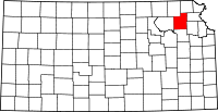 | |
| Unincorporated communities | ||
| Indian reservations | ||
| Townships | ||
| Footnotes | ‡This populated place also has portions in an adjacent county or counties | |
This article is issued from
Wikipedia.
The text is licensed under Creative Commons - Attribution - Sharealike.
Additional terms may apply for the media files.