Garabit viaduct
| Garabit Viaduct | |
|---|---|
 | |
| Coordinates | 44°58′31″N 3°10′39″E / 44.97528°N 3.17750°E |
| Carries | railway |
| Crosses | river Truyère |
| Characteristics | |
| Material | Wrought iron |
| Total length | 565 m (1,854 ft) |
| Longest span | 165 m (541 ft) |
| History | |
| Architect | Gustave Eiffel |
| Construction start | 1882 |
| Construction end | 1884 |
| Construction cost | 3,100,000 francs |
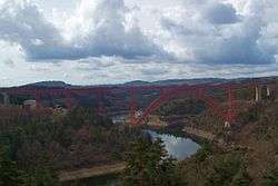
The Garabit Viaduct (Viaduc de Garabit in French) is a railway arch bridge spanning the Truyère, near Ruynes-en-Margeride, Cantal, France, in the mountainous Massif Central region.
The bridge was constructed between 1882 and 1884 by Gustave Eiffel, with structural engineering by Maurice Koechlin,[1] and was opened in 1885. It is 565 m (1,854 ft) in length and has a principal arch of 165 m (541 ft) span.[2]
Background
By the late 1870s, Eiffel & Cie, the company founded by Eiffel in partnership with Théophile Seyrig, had established a place among the leading French engineering companies. Between 1875 and 1877, the company had built the Maria Pia Bridge over the Douro at Porto, and when the construction of a railway between Marvejols and Neussargues, both in Cantal, was proposed, the work of constructing a viaduct to cross the Truyère was given to Eiffel without the usual process of competitive tendering. That was at the recommendation of the state engineers since the technical problems involved were similar to those of the Maria Pia Bridge. Indeed, it was Eiffel & Cie's success with that project that had led to the proposal for a viaduct at Garabit.[3]
Design and construction
 |
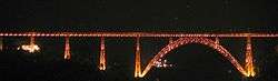 |
Opening with a single track in November 1885, the Garabit Viaduct was 565 m (1,854 ft) long and weighed 3,587 tonnes (3,530 long tons; 3,954 short tons). Even more impressively, the actual deflection (load displacement) was measured at 8 millimetres (0.315 in), just what had been calculated by Eiffel. At 124 m (407 ft) above the river, the bridge was the world's highest when it was built.[4][5] The overall project cost was 3,100,000 francs.[6]
Until 11 September 2009, one regular passenger train each way passed daily over the viaduct: a Corail route from Clermont-Ferrand to Béziers. On that date, the viaduct closed after cracks were discovered in one of the foundation piles.[7] After a safety inspection, the Garabit viaduct reopened the next month, with a speed limit of 10 km/h (6 mph) for all traffic.[8]
In popular culture
In 1976, it was used to represent the condemned "Cassandra Crossing" bridge in the film The Cassandra Crossing.[9] In the film, the bridge is depicted as being unused and derelict for 30 or 40 years and is considered dangerous, to the extent that people living nearby moved away fearing it could collapse.
References
- ↑ Loyrette 1985, p. 77
- ↑ Loyrette 1985, p. 81
- ↑ Loyrette 1985, p. 77
- ↑ HighestBridges.com
- ↑ Harvie 2006, p. 52
- ↑ Le Viaduc de Garabit at www.cantalpassion.com
- ↑ La Montagne, 12 September 2009
- ↑ "140 camions en plus par jour (et des autocars TER) si la ligne des Causses ferme", La Montagne, 20 July 2014
- ↑ Billington 1983, p. 92.
Bibliography
- Billington, David P. The Tower and the Bridge: The New Art of Structural Engineering. Princeton, New Jersey: Princeton University Press, 1983. ISBN 978-0-691-02393-9.
- Harvie, David I. Eiffel: The Genius Who Reinvented Himself. Stroud, Gloucestershire: Sutton, 2006 ISBN 0-7509-3309-7
- Loyrette, Henri. Gustave Eiffel. New York: Rizzoli,1985 ISBN 0-8478-0631-6