Neussargues-Moissac
| Neussargues-Moissac | |
|---|---|
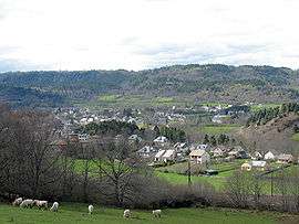 A general view of Neussargues-Moissac | |
 Neussargues-Moissac Location within Auvergne-Rhône-Alpes region  Neussargues-Moissac | |
| Coordinates: 45°07′45″N 2°58′37″E / 45.1292°N 2.9769°ECoordinates: 45°07′45″N 2°58′37″E / 45.1292°N 2.9769°E | |
| Country | France |
| Region | Auvergne-Rhône-Alpes |
| Department | Cantal |
| Arrondissement | Saint-Flour |
| Canton | Murat |
| Area1 | 13.62 km2 (5.26 sq mi) |
| Population (2008)2 | 968 |
| • Density | 71/km2 (180/sq mi) |
| Time zone | UTC+1 (CET) |
| • Summer (DST) | UTC+2 (CEST) |
| INSEE/Postal code | 15141 /15170 |
| Elevation | 738–1,022 m (2,421–3,353 ft) |
|
1 French Land Register data, which excludes lakes, ponds, glaciers > 1 km2 (0.386 sq mi or 247 acres) and river estuaries. 2 Population without double counting: residents of multiple communes (e.g., students and military personnel) only counted once. | |
Neussargues-Moissac (in Occitan Nuçargue-Moissac) is a former commune in the Cantal department in south-central France. On 1 December 2016, it was merged into the new commune Neussargues en Pinatelle.[1][2]
Population
| Historical population | ||
|---|---|---|
| Year | Pop. | ±% |
| 1962 | 1,247 | — |
| 1968 | 1,252 | +0.4% |
| 1975 | 1,213 | −3.1% |
| 1982 | 1,186 | −2.2% |
| 1990 | 1,231 | +3.8% |
| 1999 | 1,030 | −16.3% |
| 2008 | 968 | −6.0% |
Sights
- Château St Benoît: owned by the family of Olivier Messiaen's first wife, Claire Delbos. Messiaen worked on L'Ascension there.
- Castle Marguerite (Villa ou Château Marguerite): 19th century building.
- The Valley of Alagnon
The Alagnon River is tributary of the Allier River
Personalities
- Olivier Messiaen[3][4]
- Claire Delbos, violinist, first wife of the composer Olivier Messiaen.
See also
References
- ↑ Arrêté préfectoral 21 September 2016 (in French)
- ↑ Arrêté préfectoral, correcting the creation date
- ↑ OM 022a - L'Ascension, pour orchestre [Paris /Neussargues, mai /juillet 1932 puis Monaco,mai /juillet 1933 > 9 février 1934].
- ↑ OM 022b - L'Ascension, pour orgue [Neussargues, été 1933 puis Paris, 1934].
External links
| Wikimedia Commons has media related to Neussargues-Moissac. |
- (in French) about Mr. Maurice Guibal Murat at the end of the 19th century: a city, a mayor, a newspaper by Jean-Louis Philippart
- (in English) http://www.neussargues-moissac.fr/gb_patrimoine.htm
- (in English) Volcano Park of Auvergne on the UNEP-WCMC site
- Infography about Olivier Messiaen
- (in French) Albepierre-Bredons
This article is issued from
Wikipedia.
The text is licensed under Creative Commons - Attribution - Sharealike.
Additional terms may apply for the media files.