Gage Park, Chicago
| Gage Park | |
|---|---|
| Community area | |
| Community Area 63 - Gage Park | |
.jpg) Gage Park branch of Chicago Public Library on 55th Street. | |
 Location within the city of Chicago | |
| Coordinates: 41°47.4′N 87°41.4′W / 41.7900°N 87.6900°WCoordinates: 41°47.4′N 87°41.4′W / 41.7900°N 87.6900°W | |
| Country |
|
| State |
|
| County | Cook |
| City | Chicago |
| Neighborhoods |
list
|
| Area | |
| • Total | 2.24 sq mi (5.80 km2) |
| Population (2015) | |
| • Total | 41,202[1] |
| Demographics 2015[1] | |
| • White | 3.54% |
| • Black | 3.26% |
| • Hispanic | 92.25% |
| • Asian | 0.85% |
| • Other | 0.10% |
| Time zone | UTC-6 (CST) |
| • Summer (DST) | UTC-5 (CDT) |
| ZIP Codes | parts of 60609, 60629, 60632 and 60636 |
| Median income | $38,852[1] |
| Source: U.S. Census, Record Information Services | |
Gage Park is one of Chicago's 77 well-defined community areas, located on the city's southwest side; it is also the name of a park within the neighborhood. Gage Park's population is largely working-class, and its housing stock is mostly bungalows. For generations, the neighborhood was Eastern European and Irish Catholic. The neighborhood remains overwhelmingly Catholic with the addition of many Hispanic residents.
History
The development of Gage Park began in 1873 when South Park Commissioner George W. Gage began working on a planned park at the intersection of Western Ave. and Garfield Boulevard. Upon Gage's death in 1875, the park was renamed Gage Park in his honor.
The area developed after Gage's passing, slowly adding more and more land and offering up more services to the local community. By 1919, Gage Park had added more land and the park now included ball fields, tennis courts, separate men's and women's gymnasiums, gardens, and a wading pool. A large field house and auditorium was later added in 1928, with a large mural by Tom Lea added in 1931.
On February 4, 2016, the bodies of six people were discovered in a home on the 5700 block of South California Avenue.
Education
Chicago Public Schools operates district public schools.[2]
- K-8 schools include Carson, Fulton, Henderson, Hernandez, Morrill, Nightingale, Sandoval, Sawyer, and Tonti[3]
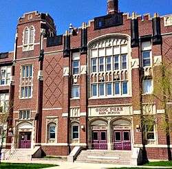
- Gage Park High School serves most of the community area. Some sections are served by Hubbard, Kelly, and Solorio high schools.[4] Gage Park High School is located on South Rockwell Street, where 728 students attended during the 2013-2014 school year. Of the 728, 96.6% were from low-income households and 18.3% are homeless. The average ACT score in 2014 was 15.2 with the state average being 20. [5]
The United Neighborhood Organization operates the charter schools Rufino Tamayo School and the UNO Soccer Academy .[6]
| Historical population | |||
|---|---|---|---|
| Census | Pop. | %± | |
| 1930 | 31,535 | — | |
| 1940 | 30,343 | −3.8% | |
| 1950 | 30,149 | −0.6% | |
| 1960 | 28,244 | −6.3% | |
| 1970 | 26,698 | −5.5% | |
| 1980 | 24,445 | −8.4% | |
| 1990 | 26,957 | 10.3% | |
| 2000 | 39,193 | 45.4% | |
| 2010 | 39,894 | 1.8% | |
| Est. 2015 | 41,202 | 3.3% | |
| [1][7] | |||
Notable people
- Victor Adeyanju, defensive end in the National Football League. Adeyanju, who lived in Gage Park from age seven until graduating high school, played for the St. Louis Rams from 2006 to 2010.[8]
References
- 1 2 3 4 "Community Data Snapshot - Gage Park" (PDF). cmap.illinois.gov. MetroPulse. Retrieved November 29, 2017.
- ↑ "Gage Park." City of Chicago. Retrieved on January 21, 2017. Compare this map to the CPS maps.
- ↑ "South" (elementary school zones). Chicago Public Schools. July 19, 2013. Retrieved on January 11, 2017.
- ↑ "West Central South" (high school zones). Chicago Public Schools. July 19, 2013. Retrieved on January 11, 2017.
- ↑ "Gage Park High School (9-12) - City of Chicago SD 299". Illinois Report Card. Illinois State Board of Education. Retrieved 17 June 2015.
- ↑ "UNO Charter Schools Archived April 30, 2012, at the Wayback Machine.." United Neighborhood Organization. Retrieved on June 16, 2012.
- ↑ Paral, Rob. "Chicago Community Areas Historical Data". Archived from the original on 18 March 2013. Retrieved 3 September 2012.
- ↑ Breen, Justin (December 16, 2014). "After Injury, Former NFL Player Becomes Full-Time 'Computer Geek'". DNAInfo Chicago. Archived from the original on September 25, 2017. Retrieved September 24, 2017.
External links
Places adjacent to Gage Park, Chicago | |
|---|---|