Greater Toronto and Hamilton Area
| Greater Toronto and Hamilton Area | |
|---|---|
| Metropolitan Area | |
| Nickname(s): GTHA | |
| Country |
|
| Province |
|
| Area | |
| • Total | 8,262.26 km2 (3,190.08 sq mi) |
| Population (2016)[1][2][3][4][5][6] | |
| • Total | 7,165,061 |
| • Density | 922/km2 (2,362/sq mi) |
| Combined population of Hamilton, Halton, Peel, Toronto, York, Durham | |
| Time zone | UTC-5 (EST) |
| • Summer (DST) | UTC-4 (EDT) |
| Postal Code | L, M |
| Area code(s) | 226/519, 416/437/647, 705, 905/289/365 |
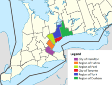
The Greater Toronto and Hamilton Area.
The Greater Toronto and Hamilton Area (GTHA) is a contiguous urban region that is composed of some of the largest cities and metropolitan areas by population in Ontario, Canada. The GTHA consists of the Greater Toronto Area (GTA) and the city of Hamilton. The former includes the city of Toronto and the regional municipalities of Halton, Peel, York, and Durham.
The GTA population is 6,417,516 (2016 census). Beginning in the late-2000s, the term "Greater Toronto and Hamilton Area" was introduced by a few public bodiesa to refer to the GTA plus the former Regional Municipality of Hamilton–Wentworth. The population of the combined area is 7,165,061 as of 2011,[7] and is projected to grow to 10.6 million by 2031.[8]
Municipalities and populations
| Authority | Type | Population (2016)[9] |
|---|---|---|
| Ajax | Town | 119,677 |
| Aurora | Town | 55,445 |
| Brampton | City | 593,638 |
| Brock | Township | 11,642 |
| Burlington | City | 183,314 |
| Caledon | Town | 66,502 |
| Clarington | Municipality | 92,013 |
| Durham | Regional Municipality | 645,862 |
| East Gwillimbury | Town | 23,991 |
| Georgina | Town | 45,418 |
| Halton | Regional Municipality | 548,435 |
| Halton Hills | Town | 61,161 |
| Hamilton | City | 536,917 |
| King | Township | 24,512 |
| Markham | City | 328,966 |
| Milton | Town | 110,128 |
| Mississauga | City | 721,599 |
| Newmarket | Town | 84,224 |
| Oakville | Town | 193,832 |
| Oshawa | City | 159,458 |
| Peel | Regional Municipality | 1,381,739 |
| Pickering | City | 91,771 |
| Richmond Hill | Town | 195,022 |
| Scugog | Township | 21,617 |
| Toronto | City | 2,731,571 |
| Uxbridge | Township | 21,176 |
| Vaughan | City | 306,233 |
| Whitby | Town | 128,377 |
| Whitchurch–Stouffville | Town/Municipality | 45,837 |
| York | Regional Municipality | 1,109,909 |
See also
Footnotes
- ^a - Adopters include the regional transportation planning body Metrolinx,[10] the Ministry of Energy and Infrastructure[11] and the Regional Municipality of Halton.[12]
References
- ↑ Hamilton:"(Code 3525) Census Profile". 2011 census. Statistics Canada. 2012. Retrieved 2012-03-01.
- ↑ Halton: "(Code 3524) Census Profile". 2011 census. Statistics Canada. 2012. Retrieved 2012-03-01.
- ↑ Peel: "(Code 3521) Census Profile". 2011 census. Statistics Canada. 2012. Retrieved 2012-03-01.
- ↑ Toronto: "(Code 3520) Census Profile". 2011 census. Statistics Canada. 2012.
- ↑ York: "(Code 3519) Census Profile". 2011 census. Statistics Canada. 2012. Retrieved 2012-03-01.
- ↑ Durham: "(Code 3518) Census Profile". 2011 census. Statistics Canada. 2012. Retrieved 2012-03-01.
- ↑ Census Profile - Select from a list. 2.statcan.gc.ca (2013-01-08). Retrieved on 2013-07-26.
- ↑ "The Big Move". Metrolinx. 2008. Retrieved 2014-03-12.
- ↑ Canada, Government of Canada, Statistics. "Population and Dwelling Count Highlight Tables, 2016 Census". www12.statcan.gc.ca. Retrieved 2017-03-06.
- ↑ "About Us". Metrolinx Website. Metrolinx.
- ↑ "Places to Grow: Growth Plan for the Greater Golden Horseshoe" (PDF). Ministry of Public Infrastructure Renewal. 2006. p. 9. Archived from the original (PDF) on 2011-07-06.
- ↑ "Amendment No. 38 to the Regional Plan (2006)". Regional Municipality of Halton. 2009-12-16.
This article is issued from
Wikipedia.
The text is licensed under Creative Commons - Attribution - Sharealike.
Additional terms may apply for the media files.