Furman, Alabama
| Furman, Alabama | |
|---|---|
| Unincorporated community | |
 Furman, Alabama Location within the state of Alabama  Furman, Alabama Furman, Alabama (the US) | |
| Coordinates: 32°0′24.53″N 86°58′0.94″W / 32.0068139°N 86.9669278°W | |
| Country | United States |
| State | Alabama |
| County | Wilcox |
| Elevation | 292 ft (89 m) |
| Time zone | UTC-6 (Central (CST)) |
| • Summer (DST) | UTC-5 (CDT) |
| Area code(s) | 334 |
Furman, also known as Old Snow Hill, is an unincorporated community in Wilcox County, Alabama, United States.[1] The Furman Historic District is included on the National Register of Historic Places.[2]
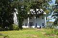 Patience Plantation, completed c. 1842
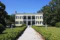 Wakefield Plantation
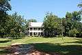 Perdue-Williams Estes House, completed c. 1895
Demographics
| Historical population | |||
|---|---|---|---|
| Census | Pop. | %± | |
| 1890 | 195 | — | |
| 1900 | 184 | −5.6% | |
| 1910 | 125 | −32.1% | |
| 1920 | 190 | 52.0% | |
| 1930 | 229 | 20.5% | |
| U.S. Decennial Census[3] | |||
Furman was listed as an incorporated community from 1890 to 1930 on the U.S. Census rolls. It either disincorporated or lost its charter after 1930.
Geography
Furman is located at 32°00′25″N 86°58′01″W / 32.00681°N 86.96692°WCoordinates: 32°00′25″N 86°58′01″W / 32.00681°N 86.96692°W and has an elevation of 292 feet (89 m).[1]
References
| Wikimedia Commons has media related to Furman, Alabama. |
- 1 2 U.S. Geological Survey Geographic Names Information System: Furman, Alabama
- ↑ National Park Service (2008-04-15). "National Register Information System". National Register of Historic Places. National Park Service.
- ↑ "U.S. Decennial Census". Census.gov. Archived from the original on May 12, 2015. Retrieved June 6, 2013.
Municipalities and communities of Wilcox County, Alabama, United States | ||
|---|---|---|
| City | 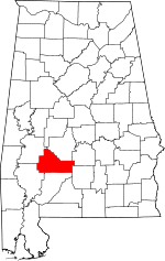 | |
| Towns | ||
| CDPs | ||
| Unincorporated communities | ||
| Ghost towns | ||
This article is issued from
Wikipedia.
The text is licensed under Creative Commons - Attribution - Sharealike.
Additional terms may apply for the media files.