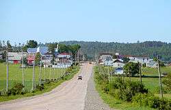
Fugèreville, Quebec
| Fugèreville | |
|---|---|
| Municipality | |
 | |
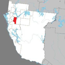 Location within Témiscamingue RCM. | |
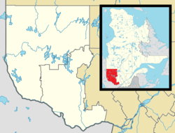 Fugèreville Location in western Quebec. | |
| Coordinates: 47°24′N 79°12′W / 47.400°N 79.200°WCoordinates: 47°24′N 79°12′W / 47.400°N 79.200°W[1] | |
| Country |
|
| Province |
|
| Region | Abitibi-Témiscamingue |
| RCM | Témiscamingue |
| Settled | 1902 |
| Constituted | February 5, 1904 |
| Government[2] | |
| • Mayor | André Pâquet |
| • Federal riding | Abitibi—Témiscamingue |
| • Prov. riding | Rouyn-Noranda–Témiscamingue |
| Area[2][3] | |
| • Total | 167.60 km2 (64.71 sq mi) |
| • Land | 156.84 km2 (60.56 sq mi) |
| Population (2011)[3] | |
| • Total | 329 |
| • Density | 2.1/km2 (5/sq mi) |
| • Pop (2006–11) |
|
| • Dwellings | 210 |
| Time zone | UTC−5 (EST) |
| • Summer (DST) | UTC−4 (EDT) |
| Postal code(s) | J0Z 2A0 |
| Area code(s) | 819 |
Fugèreville is a municipality in northwestern Quebec, Canada in the Témiscamingue Regional County Municipality.
Demographics
Population trend:[4]
- Population in 2011: 329 (2006 to 2011 population change: 9.3%)
- Population in 2006: 301
- Population in 2001: 345
- Population in 1996: 376
- Population in 1991: 398
Private dwellings occupied by usual residents: 132 (total dwellings: 210)
Mother tongue:[5]
- English as first language: 3.3%
- French as first language: 96.7%
- English and French as first language: 0%
- Other as first language: 0%
See also
References
- ↑ Reference number 24101 of the Commission de toponymie du Québec (in French)
- 1 2 "Fugèreville". Répertoire des municipalités (in French). Ministère des Affaires municipales, des Régions et de l'Occupation du territoire. Retrieved 2010-12-31.
- 1 2 "Fugèreville census profile". 2011 Census data. Statistics Canada. Retrieved 2010-12-31.
- ↑ Statistics Canada: 1996, 2001, 2006, 2011 census
- ↑ "Fugèreville community profile". 2006 Census data. Statistics Canada. Retrieved 2010-12-31.
Adjacent Municipal Subdivisions | ||||||||||
|---|---|---|---|---|---|---|---|---|---|---|
| ||||||||||
| Cities | |
|---|---|
| Municipalities | |
| Townships |
|
| Parishes | |
| Villages | |
| Unorganized territories | |
| |
This article is issued from
Wikipedia.
The text is licensed under Creative Commons - Attribution - Sharealike.
Additional terms may apply for the media files.