Francisco Morazán Department
| Francisco Morazán Department Departamento de Francisco Morazán | ||
|---|---|---|
| Department | ||
| ||
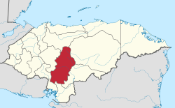 Location of Francisco Morazán in Honduras | ||
| Coordinates: 14°6′N 87°13′W / 14.100°N 87.217°WCoordinates: 14°6′N 87°13′W / 14.100°N 87.217°W | ||
| Country |
| |
| Municipalities | 28 | |
| Villages | 274 | |
| Founded | 28 June 1825[lower-alpha 1] | |
| Capital city | Tegucigalpa | |
| Government | ||
| • Type | Departmental | |
| • Gobernador | Lizzi Matute Cano (2018-2022) (PNH) | |
| Area | ||
| • Total | 8,580 km2 (3,310 sq mi) | |
| Population (2015) | ||
| • Total | 1,553,379 | |
| • Density | 180/km2 (470/sq mi) | |
| Time zone | UTC-6 (CDT) | |
| Postal code | 11101, 12101 | |
| ISO 3166 code | HN-FM | |
| Statistics derived from Consult INE online database: Population and Housing Census 2013[1] | ||
Francisco Morazán (Spanish pronunciation: [fɾanˈsisko moɾaˈsan]), FMO is one of the departments of Honduras.
It is located in the central part of the nation. The departmental capital is Tegucigalpa, which is also Honduras's national capital. Until 1943 it was known as Tegucigalpa department. It was named after national hero Francisco Morazán.
The department is very mountainous, with rugged ranges covered in pine forests; which are rocky and mostly clay. Valleys, like those of Guiamaca, Talanga, and Amarateca, are interspersed among the ranges. Many of the high mountain peaks house cloud forests, like La Tigra National park or Cerro Uyuca. The extreme southeastern portion of the department has a Pacific dry forest environment, while the northern portion contains the Montaña de la Flor, home to the Jicaque people.
Francisco Morazán department covers a total surface area of 7,946 km2 (3,068 sq mi) and, in 2005, had an estimated population of 1,680,700 people.
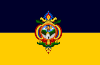
The coat-of-arms and department flag of Francisco Morazán Department are the same as its capital, Tegucigalpa.[2]
Municipalities
- Alubarén
- Cedros
- Curarén
- Distrito Central (cap. Tegucigalpa)
- El Porvenir
- Guaimaca
- La Libertad
- La Venta
- Lepaterique
- Maraita
- Marale
- Nueva Armenia
- Ojojona
- Orica
- Reitoca
- Sabanagrande
- San Antonio de Oriente
- San Buenaventura
- San Ignacio
- San Juan de Flores
- San Miguelito
- Santa Ana
- Santa Lucía
- Talanga
- Tatumbla
- Valle de Ángeles
- Vallecillo
- Villa de San Francisco
Notes
- ↑ The department of Tegucigalpa (renamed Francisco Morazán in 1943) was one of the first 7 departments in which the national territory was divided in the first political division of Honduras in 1825.
See also
References
- ↑ "Consulta Base de datos INE en línea: Censo de Población y Vivienda 2013" [Consult INE online database: Population and Housing Census 2013]. Instituto Nacional de Estadística (INE) (in Spanish). El Instituto Nacional de Estadística (INE). 1 August 2018. Retrieved 2018-09-13.
- ↑ Crwflags.com: Francisco Morazán Department