Fort Peyton
| Fort Peyton | |
|---|---|
|
South of Moultrie Creek Near St. Augustine, Florida in United States | |
 Fort Peyton Location of Fort Peyton  Fort Peyton Fort Peyton (the US) | |
| Coordinates | 29°49′29″N 81°21′36″W / 29.82472°N 81.36000°WCoordinates: 29°49′29″N 81°21′36″W / 29.82472°N 81.36000°W |
| Site information | |
| Website | Waymarking.com |
| Site history | |
| Built | August 1837 |
| Built by | United States Army |
| In use | 1840 |
| Materials | Pine log stockade and buildings |
| Fate | Abandoned in May 1840, burnt to the ground on February 14, 1842 |
| Events | Capture of Seminole leader Osceola occurred nearby on October 21, 1837 |
| Garrison information | |
| Past commanders | Lt. Richard H. Peyton |
| Garrison | Regular army troops |
Fort Peyton was a stockaded fort built in August 1837 by the United States Army, one of a chain of military outposts created during the Second Seminole War for the protection of the St. Augustine area iin Florida Territory.[1] Established by Maj. Gen. Thomas Jesup, it was garrisoned by regular army troops.
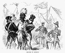
The fort stood about seven miles southwest of St. Augustine,[2] on the south side of Moultrie Creek, where the Treaty of Moultrie Creek had been signed in 1823 between the government of the United States and the chiefs of several bands of Seminoles living in the territory.[3] On October 21, 1837, the Seminole leader Osceola was captured about a mile south of this site by Gen. Joseph Marion Hernández under a white flag of truce, on Gen. Thomas Jesup's orders.[4][5]
History
On October 20, 1837, Osceola had sent Juan Caballo (also known as John Horse), a trusted Black Seminole interpreter, to call on Brig. Gen. Joseph Hernández, the commander of the militia of St. Augustine, to request an interview. Jesup ordered Hernández to agree to the meeting and seize Osceola and Coe Hadjo when he arrived. On October 21, Osceola and Coe Hadjo, accompanied by 71 Seminole warriors, six women, and four Black Seminole warriors, awaited Hernández about eight miles south of St. Augustine.[6][7]
Osceola requested that Gen. Jesup come out and talk with them. Jesup remained within the fort and did not reply, but directed Lt. Peyton to persuade Osceola and his men to come inside the fort and seize them. Osceola, however, refused to enter it, and Gen. Hernández was dispatched to parley with the Indians. Riding from St. Augustine, he picked up 250 dragoons under the command of Maj. James A. Ashby,[8] and rode on to Fort Peyton.
In the meantime, Jesup sent Lt. Peyton to learn whether the Indians had given satisfactory answers to the questions Gen. Hernández asked them; the junior officer reported that their answers were evasive and unsatisfactory. Jesup then ordered Maj. Ashby to capture Osceola and his party, even though the conference was under a white flag of truce. Major Ashby obeyed his orders, and with the aid of Hernández, took the seventy-five armed Indian warriors, including Osceola, prisoner without a gun fired. This treacherous action was a flagrant violation of the laws of warfare, resulting in Jesup being denounced in the press and roundly condemned by public opinion.[9][10]
Overview
This post was first known as Fort Moultrie, but its name was changed in honor of 1st Lieutenant Richard H. Peyton, 2nd U.S. Artillery, the post commander in 1837, who died in 1839 at Tampa.[11] The fort consisted of four log houses built in a hollow square; two occupied by the troops, one by officers, and the fourth used as a hospital and commissary. These were surrounded by a stockade. Fort Peyton was ordered abandoned by the Secretary of War, Joel Poinsett, in May 1840. The buildings burned to the ground on February 14, 1842, presumably set afire by an incendiary.
The historian Charles H. Coe mentions in his book, Red Patriots: The Story of the Seminoles, published in 1898, that a St. Augustine native named John H. Masters, a sergeant in the squadron that captured the Seminole leader, many years later guided members of the St. Augustine Historical Society to the spot where the capture took place;[12] a coquina marker with a plaque on it was placed there in 1916.[13] A spokesman for the Historical Society, however, said in 2001 that the site is about a quarter mile away from a spot shown on an 1850s map.[14]
References
- ↑ Hegarty, Joanne (May 14, 2001). "Signs marking Osceola's capture fading from view". Associated Press. Retrieved June 18, 2012.
- ↑ Charles H. Coe (1898). Red Patriots: The Story of the Seminoles. Editor Publishing Company. p. 81.
- ↑ James Leitch Wright (1986). Creeks & Seminoles: The Destruction and Regeneration of the Muscogulge People. U of Nebraska Press. p. 266. ISBN 0-8032-9728-9.
- ↑ Patricia Riles Wickman (27 August 2006). Osceola's Legacy. University of Alabama Press. p. 25. ISBN 978-0-8173-5332-2.
- ↑ Edward J. Reilly (25 June 2011). Legends of American Indian Resistance. ABC-CLIO. p. 104. ISBN 978-0-313-35209-6.
- ↑ Amanda L. Paige (19 January 2011). "Coe Hadjo". In Daniel F. Littlefield Jr., James W. Parins. Encyclopedia of American Indian Removal. ABC-CLIO. p. 54. ISBN 978-0-313-36042-8.
- ↑ Edward J. Rielly (7 June 2011). Legends of American Indian Resistance. ABC-CLIO. p. 104. ISBN 978-0-313-35210-2.
- ↑ Virginia Bergman Peters (April 1979). The Florida Wars. Archon Books. pp. 150–151. ISBN 978-0-208-01719-2.
- ↑ Samuel G. Drake (1845). The Book of the Indians, Or, Biography and History of the Indians of North America, from Its First Discovery to the Year 1841. Benjamin B. Mussey. p. 142.
- ↑ Edward Sylvester Ellis (1892). The Indian Wars of the United States: From the First Settlement at Jamestown, in 1607, to the Close of the Great Uprising of 1890-91 ... Cassell Publishing Company. p. 270.
- ↑ Arthur E. Francke (1977). Fort Mellon, 1837-42: A Microcosm of the Second Seminole war. Banyan Books. p. 98.
- ↑ Charles H. Coe (1898). Red Patriots: The Story of the Seminoles. Editor publishing Company. p. 84.
- ↑ Jennifer Edwards (October 19, 2009). "Osceola's capture site hidden". The St. Augustine Record. Gatehouse Media. Archived from the original on February 13, 2010. Retrieved 12 June 2018.
- ↑ Jim Robison (December 16, 2001). "Site Marking Osceola's Capture Could Be Park". Orlando Sentinel. Archived from the original on June 11, 2018. Retrieved 11 June 2018.