Fogo, Newfoundland and Labrador
| Fogo | ||
|---|---|---|
| Community | ||
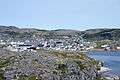
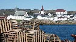 Downtown Fogo from fishing vesesl. | ||
| ||
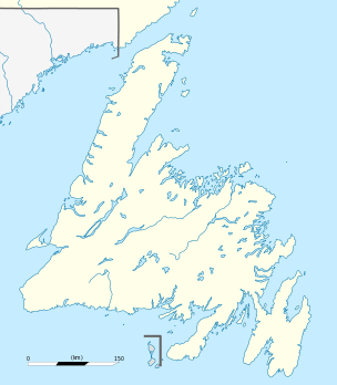 Fogo Location of Fogo in Newfoundland | ||
| Coordinates: 49°42′N 54°17′W / 49.700°N 54.283°W | ||
| Country |
| |
| Province |
| |
| Settled | early 1700s | |
| Incorporated (town) | 1948 | |
| Amalgamation[1] | March 1, 2011 | |
| Government | ||
| • Type | Fogo Island Town Council | |
| • Mayor | Andrew Shea | |
| Area | ||
| • Total | 5.92 km2 (2.29 sq mi) | |
| Elevation | 43 m (141 ft) | |
| Population (2006)[2] | ||
| • Total | 748 | |
| • Density | 126.4/km2 (327/sq mi) | |
| Time zone | UTC-3:30 (Newfoundland Time) | |
| • Summer (DST) | UTC-2:30 (Newfoundland Daylight) | |
| Postal code span | A0G | |
| Area code(s) | 709 | |
Fogo is an outport community on Fogo Island, Newfoundland in the Canadian province of Newfoundland and Labrador. It was previously incorporated as a town prior to becoming part of the Town of Fogo Island through an amalgamation in 2011.[1]
History
The second largest community on the island, Fogo may also be the location of the island's first permanent settlement, which took place in the early 18th century, though it is unknown which exact area of Fogo Island hosted the first European settlers. Some historians feel Tilting Harbour might have been the first settlement, owing to its sheltered harbour and close proximity to fishing grounds, although some local legends say that an English settlement was in place at Fogo (town) as early as 1680, this is highly unlikely. James Cook surveyed the area in the 1770s, and at that time he was told that the first English settlers in the area were in Twillingate in the year 1728. Before that, French fishermen frequented the area, but never settled permanently.
Fogo is situated on Fogo Harbour, along the island's north shore. Its economy is tied to the fishing industry and, from the 18th to 20th centuries, was home to several fish merchants.

On March 1, 2011, the Town of Fogo amalgamated with other communities to become the Town of Fogo Island.[1]
See also
External links
References
- 1 2 3 "Interim List of Changes to Municipal Boundaries, Status, and Names From January 2, 2011 to January 1, 2012 (Table 1 - Changes to census subdivisions in alphabetical order by province and territory)" (XLSX). Statistics Canada. November 14, 2012. Retrieved December 3, 2012.
- ↑ Population and dwelling counts
| Census divisions | |
|---|---|
| Cities | |
| Other communities |
|
| |