Bonavista, Newfoundland and Labrador
| Bonavista | |
|---|---|
| Town | |
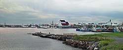 Bonavista harbour, looking north. The large building in the center of the photo houses a replica of John Cabot's ship, Matthew. | |
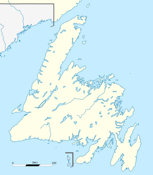 Bonavista Location of Bonavista in Newfoundland | |
| Coordinates: 48°39′35″N 53°07′15″W / 48.6597°N 53.1208°WCoordinates: 48°39′35″N 53°07′15″W / 48.6597°N 53.1208°W | |
| Country | Canada |
| Province | Newfoundland and Labrador |
| Government | |
| • Mayor | John Norman |
| Area[1] | |
| • Land | 31.5 km2 (12.2 sq mi) |
| Population (2016)[1] | |
| • Total | 3,448 |
| • Density | 109.4/km2 (283/sq mi) |
| Time zone | UTC-3:30 (Newfoundland Time) |
| • Summer (DST) | UTC-2:30 (Newfoundland Daylight) |
| Area code(s) | 709 |
| Website |
www |
Bonavista (2016 population: 3,448) is a town on the Bonavista Peninsula, Newfoundland in the Canadian province of Newfoundland and Labrador. Unlike many Newfoundland coastal settlements, Bonavista was built on an open plain, not in a steep cove, and thus had room to expand to its current area of 31.5 square kilometres.
History
Giovanni Caboto (John Cabot), a freelance Italian explorer, was contracted by England's Henry VII to find new lands, and a sea route to the Orient. Cabot set sail from Bristol, England in his ship the Matthew in 1497. When Cabot first saw land he reputedly said "O Buon Vista" ("Oh, Happy Sight!")[2][3] giving rise to the name of the town and nearby Cape Bonavista. Cabot landed with "a crucifix and raised banners with the arms of the Holy Father and those of the King of England".[4] The land was inhabited, as the expedition found a trail leading inland, a site where a fire had been, and "a stick half a yard long pierced at both ends, carved and painted with brazil".[5] The harbour was not ideal, eventually requiring the construction of several breakwaters. Despite this Bonavista became one of the most important towns in Newfoundland due to its proximity to the rich fishing and sealing grounds to the north of the peninsula. The Spanish, Portuguese, French and English fished off Cape Bonavista during the 16th century, but the Spanish and Portuguese presence soon declined, leaving the French and English as the dominant powers.[6] Tension between the French and English sometimes resulted in military action, including an unsuccessful attempt in 1704 by the French to burn the town.[7] The French Shore, which had Bonavista as its eastern terminus, was established by the Treaty of Utrecht in 1713. Fishing rights in the area continued to be a source of tension between the French and English.[8]
Bonavista was a major commercial centre and the evidence for this is preserved at the Ryan Premises, a National Historic Site maintained by Parks Canada. It is a restored example of a large fish merchant's operation.
Bonavista's status was further enhanced by the development of the Fisherman's Protective Union in the early 20th century, and the creation of nearby Port Union. During the peak years of 1891-1901, the Bonavista Peninsula's population of about 20,000 was centred in Bonavista. The Bonavista Cold Storage Co. fish plant, now a Fishery Products International operation, became the centre of fishery production after the decline of salt fish markets.
In 1722 the first school in Newfoundland was built in Bonavista by Rev. Henry Jones.
Demographics
According to the 2016 census:[1]
- Population in 2016 - 3,448
- Total private dwellings 1,749
- Population density per 109.4 km2 (42.2 sq mi)
- Land area 31.50 km2 (12.2 sq mi)
- 2011 to 2016 population change -3.9%
Past demographics:
- Population in 2011 - 3,589 (2006 to 2011 population change -4.6%)
- Population in 2006 - 3,764[9] (2001 to 2006 population change -6.4%)
- Population in 2001 - 4,021 (1996 to 2001 population change -11.2%)
- Population in 1996 - 4,526
- Population in 1991 - 4,597
Climate
Bonavista has a subarctic climate due to its cold water temperatures surrounding the location, keeping June temperatures below 10 °C (50 °F) in terms of mean temperatures. Although winters are relatively mild by Canadian standards, there is heavy snowfall and frequent cold days.
Bonavista is the windiest place in Canada with an average wind speed of 32.6 km/h (20.3 mph).[10]
| Climate data for Bonavista | |||||||||||||
|---|---|---|---|---|---|---|---|---|---|---|---|---|---|
| Month | Jan | Feb | Mar | Apr | May | Jun | Jul | Aug | Sep | Oct | Nov | Dec | Year |
| Record high °C (°F) | 12.4 (54.3) |
11.8 (53.2) |
13.4 (56.1) |
21.5 (70.7) |
25.6 (78.1) |
28.8 (83.8) |
30.6 (87.1) |
30.1 (86.2) |
26.1 (79) |
22.8 (73) |
17.8 (64) |
14.4 (57.9) |
30.6 (87.1) |
| Average high °C (°F) | −1.6 (29.1) |
−2.4 (27.7) |
0.3 (32.5) |
4.1 (39.4) |
9 (48) |
14.2 (57.6) |
19 (66) |
19.1 (66.4) |
15.2 (59.4) |
10 (50) |
5.4 (41.7) |
0.9 (33.6) |
7.8 (46) |
| Daily mean °C (°F) | −4.95 (23.09) |
−6.0 (21.2) |
−2.95 (26.69) |
1.05 (33.89) |
5.2 (41.4) |
9.7 (49.5) |
14.6 (58.3) |
15.3 (59.5) |
11.8 (53.2) |
7.1 (44.8) |
2.8 (37) |
−2.0 (28.4) |
4.3 (39.7) |
| Average low °C (°F) | −8.3 (17.1) |
−9.6 (14.7) |
−6.2 (20.8) |
−2 (28) |
1.3 (34.3) |
5.2 (41.4) |
10.1 (50.2) |
11.4 (52.5) |
8.4 (47.1) |
4.2 (39.6) |
0 (32) |
−4.9 (23.2) |
0.8 (33.4) |
| Record low °C (°F) | −24.4 (−11.9) |
−24.7 (−12.5) |
−24.3 (−11.7) |
−13.6 (7.5) |
−6.7 (19.9) |
−2.8 (27) |
−2.2 (28) |
2.8 (37) |
0.8 (33.4) |
−3.3 (26.1) |
−11.6 (11.1) |
−22.2 (−8) |
−24.7 (−12.5) |
| Average precipitation mm (inches) | 93.6 (3.685) |
86.2 (3.394) |
92.7 (3.65) |
76 (2.99) |
72.5 (2.854) |
79.3 (3.122) |
74.3 (2.925) |
80.2 (3.157) |
100.8 (3.969) |
113.7 (4.476) |
100.3 (3.949) |
102.4 (4.031) |
1,072 (42.202) |
| Source: Environment Canada[11] | |||||||||||||
Attractions

- The Ryan Premises
- The Matthew Replica
- The Mockbeggar Plantation
- The Dungeon
- White Rock Murals
- Bonavista Lighthouse
- Bonavista Archives
- Cabot Stadium
- Puffins, whales, and icebergs
Notable people
- Adam Pardy, National Hockey League player
- Michael Ryder, National Hockey League player
See also
References
- 1 2 3 "Bonavista, T [Census subdivision], Newfoundland and Labrador and Division No. 7, CDR [Census division], Newfoundland and Labrador (table) Census Profile". 2016 census. Statistics Canada.
- ↑ "Bonavista". The Canadian Encyclopedia. Historica Foundation of Canada. Archived from the original on 5 May 2010. Retrieved 17 July 2011.
- ↑ Whiffen, Bruce, Prime Berth: An Account of Bonavista's Early Years. Harry Cuff Publications Limited, St John's, A1C 2H2. 1993. ISBN 0-921191-82-0. page 4: "There are no contemporary documents to directly support this story."
- ↑ John Day's letter to Columbus, quoted in Whiffen, op. cit. page 6.
- ↑ John Day's letter, as above.
- ↑ "The International Fishery of the 16th Century". Newfoundland and Labrador Heritage Web Site Project, Memorial University of Newfoundland. 1997. Retrieved 26 January 2008.
- ↑ Bernard Ransom (1991). "Museum Notes: A Century of Armed Conflict in Newfoundland". The Rooms, Newfoundland Provincial Museum. Archived from the original on 3 March 2008. Retrieved 26 January 2008.
- ↑ J.K. Hiller (2001). "The French Treaty Shore". Newfoundland and Labrador Heritage Web Site Project, Memorial University of Newfoundland. Retrieved 26 January 2008.
- ↑ "Population and dwelling counts". Statistics Canada. 2006. Retrieved 15 July 2009.
- ↑ Environment Canada Canadian Climate Normals 1981–2010
- ↑ Environment Canada Canadian Climate Normals 1971–2000 Archived 28 December 2005 at the Wayback Machine., accessed 14 July 2009
External links
| Wikimedia Commons has media related to Bonavista, Newfoundland and Labrador. |
- Official Newfoundland and Labrador Tourism - Bonavista
- Bonavista - Encyclopedia of Newfoundland and Labrador, vol.1, p. 213-214.
| Census divisions | |
|---|---|
| Cities | |
| Other communities |
|
| |