Florida State Road 80
| ||||
|---|---|---|---|---|
| Route information | ||||
| Maintained by FDOT | ||||
| Length | 123.500 mi[1] (198.754 km) | |||
| Existed | 1945 renumbering (definition) – present | |||
| Major junctions | ||||
| West end |
| |||
|
| ||||
| East end |
| |||
| Location | ||||
| Counties | Lee, Hendry, Palm Beach | |||
| Highway system | ||||
| ||||

State Road 80 (SR 80) (also known as Palm Beach Boulevard in Lee County and Southern Boulevard in Palm Beach County) is a 123.5 miles (198.8 km) route linking US 41 Business in Fort Myers and State Road A1A in Palm Beach. The road is the northernmost of three linking Southwest Florida to South Florida via the Everglades (Alligator Alley and Tamiami Trail being the other two). Due to increasing traffic, State Road 80 has experienced upgrades and widening in various sections since 2000.
Route description
Lee and Hendry Counties
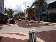
State Road 80 begins at an intersection with US 41 (Tamiami Trail) in downtown Fort Myers. From the terminus, it runs briefly along Main Street and Monroe Street though historic downtown Fort Myers to State Road 82, where it becomes discontinuous. State Road 80 resumes at Fowler Street (US 41 Business/SR 739), where it runs east as a pair of two-lane, one-way streets weaving through central Fort Myers, with westbound lanes on First Street, and the eastbound lanes running on Second Street. The eastbound lanes rejoin the westbound lanes via Seaboard Street (a former Seaboard Air Line Railroad corridor) just east of Dean Park, forming the four-lane divided Palm Beach Boulevard. From there, it follows the Caloosahatchee River east out of the city, expanding to six lanes east of the Ortiz Avenue (CR 865) intersection in Tice. It has an interchange with Interstate 75 as it passes through the eastern suburbs of Fort Myers before being reduced to four lanes east of SR 31 before leaving Lee County and entering Hendry County. At its county seat, LaBelle, it serves as the town's main street and intersects SR 29. After LaBelle, it becomes a two-lane highway until an interchange with US 27, where the two roads run concurrently as a four-lane highway as it heads east towards Clewiston and the southern coast of Lake Okeechobee.[2][3]
Palm Beach County
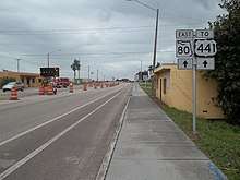
In Palm Beach County, it serves as a commuter route between South Bay and Belle Glade at the western end, growing suburbs Loxahatchee, Wellington, Royal Palm Beach and county seat West Palm Beach. In South Bay, US 27 heads south towards Miami, following the North New River Canal. Between Belle Glade and Loxahatchee, the roads are surrounded by sugarcane fields, with US 441 and US 98 both joining State Road 80 during this stretch. Lion Country Safari marks the beginning of a rural to urban transition of the road for the remainder of its journey. The road doubles from four to eight lanes in Royal Palm Beach, as the road serves as the border between Royal Palm Beach and Wellington. At the State Road 7 intersection, US 441 turns south towards Miami. The South Florida Fairgrounds and the Coral Sky Amphitheater, where the South Florida Fair takes place, are next on the route, just east of SR 7. After passing Florida's Turnpike, it gains two more lanes and becomes an expressway, with diamond interchanges with Jog Road, Haverhill Road and Military Trail. East of Military Trail, it loses a lane in each direction as it straddles the southern end of Palm Beach International Airport, where private aircraft are serviced, with commercial access to the airport available via SR 704A. It then approaches a bridge over the Tri-Rail main line as it intersects Interstate 95 at Exit 68, then becomes a four-lane road in several older, high-density neighborhoods in West Palm Beach. East of the Florida East Coast Railway bridge crossing, it intersects US 1 and SR 5, reducing to two lanes as it crosses Lake Worth Lagoon on two bridges, and ending on a roundabout with SR A1A in Palm Beach near the Mar-a-Lago estate.[2][3]
History
The route of State Road 80 was largely built in the 1920s. The first vehicle to travel the route from Belle Glade to Palm Beach was in 1923.[4] The section from Twenty Mile Bend to West Palm Beach was considered part of the Conners Highway, which opened on July 4, 1924. Segments west of Lake Okeechobee would be completed by 1926.[5]
The route was first designated State Road 25 in 1923, running from Palm Beach to Punta Rassa. As a result of the 1945 Florida State Road renumbering, the route became State Road 80 from Fort Myers to Palm Beach, and the segment west of Fort Myers to Punta Rassa became State Road 867. (Ironically, State Road 25 still applies today to the concurrency with US 27 as that is now US 27’s hidden designation).
The segment between Belle Glade and Twenty Mile Bend, known as the Kenneth C. Mock Memorial Highway was completed in 1989, making SR 80 a four-lane divided highway between Belle Glade and West Palm Beach. Prior to this, SR 80 (and US 441) ran just to the south along what is now County Road 880.[6] US 98, which previously ran along SR 700 (Conners Highway), would later be rerouted onto this route beginning around 2000.
Until 2002, Palm Beach County's Southern Boulevard was a four-lane road with a center left-turn lane, causing high gridlock due to the rapidly growing western suburbs of Loxahatchee, Royal Palm Beach and Wellington.[7] The road was known as "Killer 80" due to its high fatality rate.[8] In 2002, after many years of debate, the Florida Department of Transportation embarked on a $78 million project to upgrade and widen Southern Boulevard from I-95 to US 441/SR 7.[7] Between 2003 and 2008, it was transformed into a limited-access highway with freeway-grade diamond interchanges at the most congested intersections, with traffic signals remaining at others.[9][10]
State Road 80's routing through downtown Fort Myers has changed a few times over the years. When designated in 1945, State Road 80 terminated at First and Fowler Streets (which carried US 41 when it crossed the Edison Bridge). SR 80 would be extended through downtown in 1964 when US 41 was rerouted over the Caloosahatchee Bridge (with First Street also carrying the U.S. Route 41 Business route concurrently).[11] In the 1980s, SR 80 was split into one-way street pairs from Monroe Street to Palm Beach Boulevard and Seaboard Street, with eastbound traffic using Second and Seaboard Streets, and with westbound traffic using First and Bay Streets.[12] The segment between Monroe and Fowler Streets was relinquished to the city of Fort Myers on January 11, 2006 as part of the downtown redevelopment and streetscape effort, creating the gap in the route that exists today.[1][13]
In Hendry County, a project to improve the intersection between SR 80 and US 27 and add an overpass was completed at the end of 2014.[14]
Future
The two bridges crossing Lake Worth Lagoon, built in 1950, are currently in the planning stages for replacement, with construction expected to begin in 2015.[15]
Construction is underway to widen SR 80 east of LaBelle from Dalton Lane to CR 833 to a four-lane divided highway. This is the only remaining undivided two-lane segment of SR 80 between Fort Myers and West Palm Beach. Completion is expected in the summer of 2020.[16][17]
Major intersections
| County | Location | mi[1] | km | Destinations | Notes | ||
|---|---|---|---|---|---|---|---|
| Lee | Fort Myers | 0.000 | 0.000 | ||||
| 0.168 | 0.270 | Monroe Street south / Main Street east - Downtown | |||||
| 0.242 | 0.389 | Second Street | Former routing of SR 80 east until 2006 | ||||
| 0.316 | 0.509 | ||||||
| Gap in route | |||||||
| 0.000 | 0.000 | One-way southbound | |||||
| 0.237 | 0.381 | One-way northbound | |||||
| 0.831 | 1.337 | Billy's Creek Bridge over Billy Creek (westbound only) | |||||
| Tice | 3.861 | 6.214 | Ortiz Avenue (CR 865 south) | Northern terminus of CR 865 | |||
| | 5.060 | 8.143 | Exit 141 on I-75 | ||||
| Fort Myers Shores | 7.746 | 12.466 | Southern terminus of SR 31 | ||||
| Buckingham Road (CR 876 west) – Lehigh Acres | Eastern terminus of CR 876 | ||||||
| Alva | 17.151 | 27.602 | Broadway Street to CR 78 – Alva | ||||
| 17.724 | 28.524 | Western terminus of CR 884 | |||||
| Hendry | | 22.860 | 36.790 | Fort Denaud Road (CR 78A east) – Fort Denaud | Western terminus of CR 78A | ||
| For Denaud | 27.325 | 43.975 | Fort Denaud Road (CR 78A west) / Cowboy Way (CR 80A east) | Eastern terminus of CR 78A; western terminus of CR 80A | |||
| LaBelle | 28.450 | 45.786 | Dr. Martin Luther King Jr. Boulevard (CR 731 south) | ||||
| 29.210 | 47.009 | Western terminus of concurrency with SR 29 | |||||
| 29.277 | 47.117 | Eastern terminus of concurrency with SR 29 | |||||
| Port LaBelle | 34.230 | 55.088 | Northern terminus of CR 80A | ||||
| | 48.709 | 78.390 | Northern terminus of CR 833 | ||||
| Whidden Corner | 51.677 | 83.166 | Interchange; western terminus of concurrency with US 27 | ||||
| | 58.096 | 93.496 | Eastern terminus of CR 720 | ||||
| Clewiston | 60.670 | 97.639 | W.C. Owen Avenue (CR 832 east) | Western terminus of CR 832 | |||
| | 62.851 | 101.149 | Northern terminus of CR 835 | ||||
| Palm Beach | South Bay | 76.526 | 123.157 | Eastern terminus of concurrency with US 27 | |||
| Belle Glade | 78.329 | 126.058 | Southern terminus of SR 715; truck bypass to West Palm Beach, Pahokee, and Canal Point} | ||||
| 79.391 | 127.767 | Northern terminus of CR 827A | |||||
| 80.524 | 129.591 | Dr. Martin Luther King Jr. Boulevard (CR 880 east) | Former routing of SR 80 until 1989; western terminus of CR 880; southern terminus of SR 15 | ||||
| 80.766 | 129.980 | Canal Street South (SR 717) | |||||
| | 83.534 | 134.435 | Eastern terminus of concurrency with SR 15; western terminus of concurrency with US 98 / US 441; truck bypass to Pahokee, Canal Point, South Bay | ||||
| | 96.871 | 155.899 | Eastern terminus of SR 700; western terminus of CR 700 | ||||
| Twenty Mile Bend | 101.780 | 163.799 | Former routing of SR 80 until 1989 | ||||
| Wellington–Royal Palm Beach line | 110.479 | 177.799 | Forest Hill Boulevard / Crestwood Boulevard | To SR 882 | |||
| Royal Palm Beach | 113.25 | 182.26 | Interchange; eastern terminus of concurrency with US 441 | ||||
| | 115.47 | 185.83 | Southbound Turnpike is accessed via Pike Road; exit 97 on Turnpike | ||||
| | 116.79 | 187.96 | Jog Road | Interchange | |||
| | 118.32– 118.83 | 190.42– 191.24 | Interchange | ||||
| Glen Ridge | 120.68 | 194.22 | Interchange; northern terminus of SR 807; southern terminus of CR 704A (former SR 704A) | ||||
| West Palm Beach | 121.47 | 195.49 | Exit 68 on I-95 | ||||
| 122.392 | 196.971 | ||||||
| 122.538 | 197.206 | ||||||
| Lake Worth Lagoon | 122.87 | 197.74 | Southern Boulevard Bridge | ||||
| Palm Beach | 123.480 | 198.722 | Traffic circle; eastern terminus of US 98 | ||||
1.000 mi = 1.609 km; 1.000 km = 0.621 mi
| |||||||
References
- 1 2 3 FDOT straight line diagrams Archived March 6, 2014, at the Wayback Machine., accessed January 2014
- 1 2 Google (2010-05-03). "overview map of State Road 80" (Map). Google Maps. Google. Retrieved 2010-05-03.
- 1 2 Google Inc. (July 8, 2008). Google Earth (4.3.7284.3916) [beta]. Retrieved July 25, 2009. <http://earth.google.com/>
- ↑ Oeffner, Barbara D.; Dunning, Amie (2010). Images of America: Around Lake Okeechobee. Arcadia Publishing.
|access-date=requires|url=(help) - ↑ "Historic and Architectural Resources of laBelle". National Park Service. Retrieved 27 June 2016.
- ↑ Lowery, Fred (17 June 1985). "Highway Name To Pay Tribute To Area Engineer". Sun Sentinel. Retrieved 29 March 2016.
- 1 2 "As County Booms, State's Plans For Widening Roads Often Bust". Miami Herald 15 Feb 1987: 3PBS
- ↑ "Four Die in Crash on State Road 80". Miami Herald 23 Apr 1984: 15BR
- ↑ Palm Beach FDOT. "Southern Blvd. (SR 80) Projects". Archived from the original on 2009-04-03. Retrieved July 25, 2009.
- ↑ Regnier & Associates, Inc. "State Road 80 Expansion". Archived from the original on 2009-09-13. Retrieved July 25, 2009.
- ↑ Board, Prudy Taylor; Bartlett, Patricia Pope (1985). Lee County: A Pictorial History. Norfolk, VA: Donning Company. ISBN 0-89865-443-2.
- ↑ "Fort Myers Mobility Plan" (PDF). Spikowski Planning Associates. Retrieved 27 June 2016.
- ↑ "Fort Myers Streetscape". Retrieved 30 March 2016.
- ↑ Cella Molnar & Associates, Inc. "State Road 80, US 27". Archived from the original on 2011-02-07. Retrieved December 8, 2013.
- ↑ FDOT. "SR 80 (Southern Blvd) Bridges". Retrieved July 25, 2009.
- ↑ "Hendry County Road Watch: resurfacing project of SR 80". The Clewiston News. 1 May 2017. Retrieved 21 May 2017.
- ↑ "SR 80 Improvements From Dalton Lane to CR 833, Hendry County" (PDF). Florida Department of Transportation. Retrieved 21 May 2017.
External links
Route map:
![]()