Fisher Branch, Manitoba
| Fisher Branch Hub of the Interlake | |
|---|---|
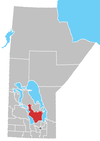
 Fisher Branch Location of Fisher Branch in Manitoba | |
| Coordinates: 51°4′59″N 97°37′12″W / 51.08306°N 97.62000°WCoordinates: 51°4′59″N 97°37′12″W / 51.08306°N 97.62000°W | |
| Country |
|
| Province |
|
| Region | Interlake |
| Census Division | No. 18 |
| Government | |
| • Governing Body | Rural Municipality of Fisher Council |
| • MP | James Bezan |
| • MLA | Thomas G. Nevakshonoff |
| Area | |
| • Total | 1.75 km2 (0.68 sq mi) |
| Elevation | 251 m (825 ft) |
| Population (Canada 2011 Census[1]) | |
| • Total | 460 |
| • Density | 260/km2 (680/sq mi) |
| Time zone | UTC−6 (CST) |
| • Summer (DST) | UTC−5 (CDT) |
| Postal code | R0C 0Z0 |
| Area code(s) | 204 |
| NTS Map | 062P04 |
| GNBC Code | GAIGX |
| Website |
www |
Fisher Branch is an unincorporated community recognized as a local urban district[2] in the Rural Municipality of Fisher in the Canadian province of Manitoba. It is located on Highway 17 in the north Interlake Region of the province. Fisher Branch was originally named Wasoo, but later was changed to Fisher Branch because it was beside a branch of the Fisher River. The primary industry of Fisher Branch is agriculture.
Local media
Television
CBWGT went on the as CBWT-1 on February 1, 1967 as part of the province-wide microwave system.[3]
Climate
| Climate data for Fisher Branch | |||||||||||||
|---|---|---|---|---|---|---|---|---|---|---|---|---|---|
| Month | Jan | Feb | Mar | Apr | May | Jun | Jul | Aug | Sep | Oct | Nov | Dec | Year |
| Record high °C (°F) | 7 (45) |
8.5 (47.3) |
16.5 (61.7) |
32.5 (90.5) |
38 (100) |
39 (102) |
35 (95) |
37.5 (99.5) |
39 (102) |
30.5 (86.9) |
18.9 (66) |
7.5 (45.5) |
39 (102) |
| Average high °C (°F) | −13.4 (7.9) |
−8.8 (16.2) |
−1.7 (28.9) |
9 (48) |
18.1 (64.6) |
22.6 (72.7) |
25.2 (77.4) |
24.2 (75.6) |
17.4 (63.3) |
9.6 (49.3) |
−2.1 (28.2) |
−11 (12) |
7.4 (45.3) |
| Daily mean °C (°F) | −18.8 (−1.8) |
−14.4 (6.1) |
−7.3 (18.9) |
2.7 (36.9) |
10.8 (51.4) |
15.7 (60.3) |
18.5 (65.3) |
17.2 (63) |
11.3 (52.3) |
4.3 (39.7) |
−6.4 (20.5) |
−15.6 (3.9) |
1.5 (34.7) |
| Average low °C (°F) | −23.9 (−11) |
−19.9 (−3.8) |
−12.8 (9) |
−3.6 (25.5) |
3.5 (38.3) |
8.8 (47.8) |
11.8 (53.2) |
10.1 (50.2) |
5.1 (41.2) |
−1 (30) |
−10.5 (13.1) |
−20.1 (−4.2) |
−4.4 (24.1) |
| Record low °C (°F) | −44 (−47) |
−45 (−49) |
−38.5 (−37.3) |
−29 (−20) |
−12.5 (9.5) |
−3 (27) |
0 (32) |
−2.5 (27.5) |
−6 (21) |
−20 (−4) |
−37 (−35) |
−41 (−42) |
−45 (−49) |
| Average precipitation mm (inches) | 18.6 (0.732) |
16.3 (0.642) |
22.6 (0.89) |
32.5 (1.28) |
48.2 (1.898) |
84.5 (3.327) |
62.9 (2.476) |
72.9 (2.87) |
62 (2.44) |
45.7 (1.799) |
25.5 (1.004) |
20.3 (0.799) |
511.9 (20.154) |
| Source: Environment Canada[4] | |||||||||||||
References
- ↑ http://www12.statcan.gc.ca/census-recensement/2011/dp-pd/prof/details/page.cfm?Lang=E&Geo1=DPL&Code1=460059&Geo2=PR&Code2=46&Data=Count&SearchText=Fisher%20Branch&SearchType=Begins&SearchPR=01&B1=All
- ↑ "Local Urban Districts Regulation". Government of Manitoba. April 23, 2016. Retrieved April 24, 2016.
- ↑ "Microwave Hook-Up Gives North Live TV". Winnipeg Free Press. April 29, 1969. p. 28.
- ↑ Environment Canada - Canadian Climate Normals 1971-2000—Canadian Climate Normals 1971–2000, accessed 17 April 2011
Division No. 18, Manitoba (North Interlake Area) | ||||
|---|---|---|---|---|
| Towns |
|  | ||
| Villages |
| |||
| Rural municipalities |
| |||
| First Nations | ||||
| Indian reserves | ||||
| Unorganized areas | ||||
| Unincorporated communities |
| |||
This article is issued from
Wikipedia.
The text is licensed under Creative Commons - Attribution - Sharealike.
Additional terms may apply for the media files.